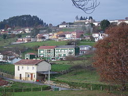
Collao

Last updated
Collao, 2005 Collado Siero.JPG
Collao, 2005
Church of San Cristobal de Collao, 2006 Iglesiacollao.jpg
Church of San Cristóbal de Collao, 2006

Collao [1] is a parish (administrative division) in Siero, a municipality within the province and autonomous community of Asturias, in northern Spain. The parish is located on Highway AS-113.

Contents

It is 0.27 km2 (0.10 sq mi) in size, and is situated at an elevation of 230 m (750 ft) above sea level. The population is 488 (INE 2006). The postal code is 33518.

Collao and other nearby parishes, such as Lieres and Carbayín, are historically associated with Andalusian mining.

Culture

Collao's patron saint festivities honor San Cristóbal, and are held every year on the first Sunday of July.

The Gazetteer of SADEI identifies five notable sites within the parish: The Cirigüeyu, Cordón, Fuentemil, Llorián and La Quintana.

Buildings unique to Collao include the Church of San Cristóbal de Collao, the old public school (now converted into a community center), and the Source of Veneros. Currently, there are two associations in Collao of social and cultural interest. The oldest of these is the Society of Celebration, which each year organizes the patron saint festival. The other is the Neighborhood Association, whose office is located in the school administration building.

Related Research Articles

<span class="mw-page-title-main">Cuevas de San Marcos</span> Place in Andalusia, Spain

Cuevas de San Marcos is a town and municipality in the province of Málaga, part of the autonomous community of Andalusia in southern Spain. The municipality is situated in the northern part of the Antequera region, on the border of the province of Córdoba from the river valley of Genil to the Sierra Malnombre and Camorro de Cuevas Altas. It is also located within the comarca of Nororma. It borders the provinces of Granada and Cordoba to the north, the comarcas of La Axarquía to the south and Antequera to the west. The town is situated at an altitude of 420 meters above sea level.

<span class="mw-page-title-main">Pola de Allande</span> Parish in Asturias, Spain

Pola de Allande is a town and a parish in Allande, a municipality within the province and autonomous community of Asturias, in northern Spain. It is surrounded by the Cantabrian mountains. It is the capital of the parish. The town was founded between 1262 and 1268. Oviedo, the capital of Asturias, is 104 km (65 mi) away. The Nison River runs through the middle of the town, known for its trout while now fishing is banned there.

<span class="mw-page-title-main">Valdesoto</span>

Valdesoto is a parish located in the southeastern part of Siero, a municipality (conceyu) in the province and autonomous community of Asturias in northern Spain. It is consecrated to Saint Felix. There are 15 villages within Valdesoto. The population as of 2005 was 1967 inhabitants. The postcode is 33938.

San Miguel de la Barreda is a parish in Siero, a municipality within the province and autonomous community of Asturias, in northern Spain. It is located along the AS-17 road.

<span class="mw-page-title-main">Lugones, Siero</span> Parish in Asturias, Spain

Lugones is a parish in Siero, a municipality within the province and autonomous community of Asturias, in northern Spain.

La Carrera is a parish in Siero, a municipality within the province and autonomous community of Asturias, in northern Spain. It is located south of Highway N-634 and north of Highway A-64. The capital, Pola de Siero, is to the northeast.

San Emiliano is a parish in Allande, a municipality within the province and autonomous community of Asturias, in northern Spain. It is situated 37 km (23 mi) from the capital, Pola de Allande.

<span class="mw-page-title-main">Castañeo'l Monte</span>

Castañeo'l Monte43°17′30″N5°59′56″W is a parish in Santo Adriano, a municipality within the province and autonomous community of Asturias, in northern Spain.

Llavares is a parish in Santo Adriano, a municipality within the province and autonomous community of Asturias, in northern Spain.

Vega de Poja is a parish in Siero, a municipality within the province and autonomous community of Asturias, in northern Spain. The parish is located to the North East of the administrative capital of the municipality, Pola de Siero, between Highway AS-331 and Highway AS-248.

Oles is one of 41 parishes in Villaviciosa, a municipality within the province and autonomous community of Asturias, in coastal northern Spain.

Zurea is one of 24 parishes in Ḷḷena, a municipality within the province and autonomous community of Asturias, in coastal northern Spain.

<span class="mw-page-title-main">Tuíza</span>

Tuíza is one of 24 parishes in Lena, a municipality within the province and autonomous community of Asturias, in coastal northern Spain.

Congostinas is one of 24 parishes in Lena, a municipality within the province and autonomous community of Asturias, in coastal northern Spain.

Sotieḷḷo is one of 24 parishes in Ḷḷena, a municipality within the province and autonomous community of Asturias, in coastal northern Spain.

Carabanzo is one of 24 parishes in Lena, a municipality within the province and autonomous community of Asturias, in coastal northern Spain.

<span class="mw-page-title-main">San Juan de Beleño</span>

San Juan de Beleño is one of nine parishes in Ponga, a municipality within the province and autonomous community of Asturias, in coastal northern Spain.

<span class="mw-page-title-main">Nimbra</span>

Nimbra is one of thirteen parishes in Quirós, a municipality within the province and autonomous community of Asturias, in coastal northern Spain.

<span class="mw-page-title-main">Chanos de Somerón</span>

Chanos de Somerón is one of 24 parishes in Lena, a municipality within the province and autonomous community of Asturias, in coastal northern Spain. The parroquia is 4.04 km2 (1.56 sq mi) in size, with a population of 32.

<span class="mw-page-title-main">Aramil (Siero)</span>

Aramil is a Spanish parroquia of Siero, in Asturias. It has a population of 347 inhabitants in 173 homes. It occupies an area of 1.83 square kilometres (0.71 sq mi). It is located 5 km from the capital, Pola de Siero, in the eastern part of the council. It has a boundary on the northwest with the parish of Marcenado and Collado; to the east with Feleches; and to the south and southwest with Santa Eulalia de Vigil. The Romanesque church of Church of San Esteban de Aramil is located in the town.

References

43°23′N5°3′W / 43.383°N 5.050°W / 43.383; -5.050