Collinsville, Ohio

Last updated

Location of Collinsville, Ohio OHMap-doton-Collinsville.png
Location of Collinsville, Ohio

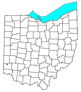
Collinsville is an unincorporated community and former village in southeastern Milford Township, Butler County, Ohio, United States. [1] It has a post office with the ZIP code 45004. [2] It lies at the intersection of U.S. Route 127 and State Route 73.

Collinsville was laid out in 1802. [3] The community was named for Charles Collins, a first settler. [4]

Collinsville receives public services from the Milford Twp. Department of Public Works. Station 161 of the Milford Twp. Fire Department is located in and services the community while the Seven Mile Fire Department and Life Squad Station 171 provide EMS service.

Related Research Articles

<span class="mw-page-title-main">Seven Mile, Ohio</span> Village in Ohio, United States

Seven Mile is a village in Butler County, Ohio, United States. The population was 712 at the 2020 census.

<span class="mw-page-title-main">Goshen, Ohio</span> Census-designated place in Ohio, United States

Goshen is a census-designated place in central Goshen Township, Clermont County, Ohio, United States. The population was 715 at the 2020 census. It is centered on State Route 28, approximately midway between Milford and Blanchester.

<span class="mw-page-title-main">Milford Township, Butler County, Ohio</span> Township in Ohio, United States

Milford Township is one of thirteen townships in Butler County, Ohio, United States. It is located between Oxford and Middletown. The township had a population of 3,523 at the 2020 census.

<span class="mw-page-title-main">Bethany, Ohio</span> Unincorporated community in Ohio, U.S.

Bethany is an unincorporated community in southeastern Liberty Township, Butler County, Ohio, United States, located in the southwestern part of Ohio. It lies about three miles south of Monroe.

<span class="mw-page-title-main">Roundhead, Ohio</span>

Roundhead is an unincorporated community in southeastern Roundhead Township, Hardin County, Ohio, United States. It has a post office with the ZIP code 43346.

<span class="mw-page-title-main">Buford, Ohio</span> Census-designated place in Ohio, United States

Buford is an unincorporated community and census-designated place in central Clay Township, Highland County, Ohio, United States. The population was 306 at the 2020 census. It once had a post office, with the ZIP code 45110. The current ZIP code 45171 is for nearby Sardinia.

<span class="mw-page-title-main">Marathon, Ohio</span> Unincorporated community in Ohio, U.S.

Marathon is an unincorporated community in eastern Jackson Township, Clermont County, Ohio, United States. Although it is unincorporated, it had a post office, with the ZIP code 45145. The current ZIP code is 45118. It lies along U.S. Route 50.

<span class="mw-page-title-main">Mount Liberty, Ohio</span>

Mount Liberty is an unincorporated community on the border between the Milford and Liberty Townships of Knox County, Ohio, United States. It has a post office with the ZIP code 43048. It lies along the concurrent U.S. Route 36 and State Route 3.

<span class="mw-page-title-main">Okolona, Ohio</span>

Okolona is an unincorporated community in southwestern Napoleon Township, Henry County, Ohio, United States. It has a post office with the ZIP code 43550. It is located along County Road 17-D a short distance southeast of U.S. Route 24.

<span class="mw-page-title-main">Hooven, Ohio</span> Census-designated place in Ohio, United States

Hooven is a census-designated place (CDP) in southeastern Whitewater Township, Hamilton County, Ohio, United States. The population was 464 at the 2020 census. Hooven has a ZIP code of 45033.

<span class="mw-page-title-main">Camp Dennison, Ohio</span> Census-designated place in Ohio, United States

Camp Dennison is a census-designated place (CDP) just outside Indian Hill in southern Symmes Township, Hamilton County, Ohio, United States. It has a post office with the ZIP code 45111. The population was 384 at the 2010 census.

<span class="mw-page-title-main">Shade, Ohio</span>

Shade is an unincorporated community in southern Lodi Township, Athens County, Ohio, United States. It has a post office with the ZIP code 45776. It lies along U.S. Route 33.

<span class="mw-page-title-main">New Marshfield, Ohio</span> Census-designated place in Ohio, United States

New Marshfield is a census-designated place in central Waterloo Township, Athens County, Ohio, United States. The population was 316 at the 2020 census. It has a post office with the ZIP code 45766. It is located along State Route 56 west of the county seat of Athens.

<span class="mw-page-title-main">Richmond Dale, Ohio</span> CDP in Ohio, United States

Richmond Dale is a census-designated place in central Jefferson Township, Ross County, Ohio, United States. It has a post office with the ZIP code 45673. It is located along U.S. Route 35 southeast of the county seat of Chillicothe. The population of the CPD was 386 at the 2020 census.

<span class="mw-page-title-main">Ida, Michigan</span> Census-designated place & unincorporated community in Michigan, United States

Ida is an unincorporated community and census-designated place (CDP) in Monroe County in the U.S. state of Michigan. The CDP had a population of 790 at the 2020 census. The community is mostly within Ida Township with a smaller portion extending north into Raisinville Township.

<span class="mw-page-title-main">Sciotoville, Ohio</span> Neighborhood in Scioto, Ohio, United States

Sciotoville is a neighborhood in the city of Portsmouth in Scioto County, Ohio. It is located at the intersection of U.S. 52 and State Route 335 between the village of New Boston and Wheelersburg in Scioto County along the northern bank of the Ohio River. It has its own post office, but shares the ZIP code of 45662 with the city of Portsmouth.

<span class="mw-page-title-main">Elmira, Michigan</span> Unincorporated community in Michigan, United States

Elmira is an unincorporated community in the U.S. state of Michigan. Located along M-32, the community is on the county line between Warner Township in Antrim County to the west and Elmira Township in Otsego County to the east.

<span class="mw-page-title-main">New Trenton, Indiana</span> Census-designated place in Indiana, United States

New Trenton is an unincorporated community and census-designated place (CDP) in Whitewater Township, Franklin County, Indiana. As of the 2010 census it had a population of 252. It has a ZIP code 47035.

<span class="mw-page-title-main">Butlerville, Indiana</span> Census-designated place in Indiana, United States

Butlerville is an unincorporated community and census-designated place (CDP) in central Campbell Township, Jennings County, Indiana, United States. As of the 2010 census it had a population of 282.

Chili is an unincorporated community and census-designated place in Rio Arriba County, New Mexico. Its population was 654 as of the 2010 census. U.S. Route 84 passes through the community. The name comes from a station of the D&RG railroad that was known locally as the "Chili Line."

References

  1. U.S. Geological Survey Geographic Names Information System: Collinsville
  2. USPS – Cities by ZIP Code Archived 2007-10-08 at the Wayback Machine
  3. Overman, William Daniel (1958). Ohio Town Names. Akron, OH: Atlantic Press. p. 32.
  4. Bartlow, Bert Surene (1905). Centennial History of Butler County, Ohio. B. F. Bowen. p. 351.

39°30′55″N84°36′34″W / 39.51528°N 84.60944°W / 39.51528; -84.60944