Fairfield is a suburban city located in Butler county in the U.S. state of Ohio. Fairfield is located approximately 25 miles north of Cincinnati and is situated on the east bank of the Great Miami River. The population was 42,623 as of the 2020 Census. Incorporated in 1955 from portions of Fairfield Township, it includes the former hamlets of Symmes Corner, Fair Play, Furmandale, and Stockton. The Fairfield City School District is one of the largest in Ohio and serves both the City of Fairfield and Fairfield Township.

Butler County is a county located in the southwestern part of the U.S. state of Ohio. As of the 2020 census, the population was 390,357. Its county seat and largest city is Hamilton. It is named for General Richard Butler, who died in 1791 during St. Clair's Defeat. Located along the Great Miami River, it is also home to Miami University, a public university founded in 1809. Butler County is part of the Cincinnati, OH-KY-IN Metropolitan Statistical Area. The majority of the county is in District 52 of the State House.

Colerain Township is one of the twelve townships of Hamilton County, Ohio, United States. The population of the township was 59,037 at the 2020 census. It is the second-largest township in Ohio by area, surpassed by Madison Township, Lake County, Ohio.

Columbia Township is one of the twelve townships of Hamilton County, Ohio, United States. The 2020 census found 4,446 people in the township. Originally one of Ohio's largest townships by area at its inception in 1791, it gradually shrank to one of the smallest by the early 1950s.

Springfield Township is one of the twelve townships of Hamilton County, Ohio, United States. The population was 35,862 as of the 2020 census. Springfield Township is home to the largest private school in Ohio, the largest lake in Hamilton County, and the Cincinnati area's annual Greek Festival.

Symmes Township is one of the twelve townships of Hamilton County, Ohio, United States. The population was 15,642 as of the 2020 census.

West Chester Township is one of the thirteen townships of Butler County, Ohio, United States, located in the southeastern corner of the county. It is the most populous township in Ohio, with a population of 65,242 at the 2020 census. Situated between Sharonville and Liberty Township, West Chester is about 18 miles (29 km) north of Cincinnati and is included in the Cincinnati metropolitan area. Exits 19, 21 and 22 off Interstate 75 serve West Chester.

Lemon Township is one of thirteen townships in Butler County, Ohio, United States. Located in the northeastern part of the county, it includes most of the city of Monroe. It had a population of 16,885 at the 2020 census. It is the only Lemon Township statewide.

Madison Township is one of thirteen townships in Butler County, Ohio, United States. Located in northeastern Butler County, just west of Middletown, it had a population of 8,556 people as of the 2020 census. While it surrounds the city of Trenton, the city is no longer part of the township. It is named for James Madison, president of the United States at the time of its creation in 1810, and is one of twenty Madison Townships statewide.
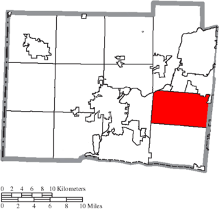
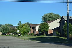
Liberty Township is a suburb of Cincinnati located in Butler County, Ohio. It is one of thirteen townships in Butler County, Ohio, United States. The population was 43,999 at the 2020 census. It is located on the east-central part of the county, just south of the city of Monroe. It was named for Liberty, Pennsylvania, at the suggestion of John Morrow, a resident in the township at the time of its formation in 1803 who was the brother of Ohio Governor Jeremiah Morrow, after his hometown. The first settler was John Nelson, who arrived in 1796, seven years before Ohio became a state. It is one of 25 Liberty Townships statewide.

St. Clair Township, one of thirteen townships in Butler County, Ohio, United States, consists of three disconnected pieces located along the Great Miami River in central Butler County. It had a population of 6,908 at the 2010 census, down from 7,336 in 2000. Exclusive of the village of New Miami and the southern part of the village of Seven Mile, which lie within its borders, the unincorporated portion of St. Clair Township had 4,404 inhabitants in 2010.

Oxford Township, also known as the College Township, is one of thirteen townships in the county and is located in the northwestern corner of Butler County, Ohio, United States, where it meets Preble County, Ohio, and Union County, Indiana. The city of Oxford and Miami University are located here. The U.S. Census Bureau counted 23,661 inhabitants in 2010, down from 24,133 in 2000. Excluding the city of Oxford and the village of College Corner there are 2,099 residents of the unincorporated portion of Oxford Township. It comprises one full survey township in the Congress Lands and is 36.9 square miles (95.6 km2) in area.

Ross Township, one of thirteen townships in the county, is located in south-central Butler County, Ohio, United States, southwest of the city of Hamilton. The population was 8,355 at the 2010 census, up from 6,448 in 2000; 7,830 of this total lived in the unincorporated portions of the township in 2010. It originally comprised twenty-seven whole and seven fractional sections in the Congress Lands.

Wayne Township, one of thirteen townships in the county, is located in north-central Butler County, Ohio, United States between Trenton and Oxford. It had a total population of 4,443 at the 2010 census, up from 4,252 in 2000. Exclusive of the two incorporated villages in the township, Jacksonburg and Seven Mile, Wayne Township had a population of 3,884 in 2010. It has an area of 36.6 square miles (94.9 km2), comprising one whole survey township in the Congress Lands.

Milford Township, one of thirteen townships in the county, is located in north-central Butler County, Ohio, United States, between Oxford and Middletown. The township had a population of 3,550 at the 2010 census, up from 3,254 in 2000. Excluding the now-defunct village of Somerville, 3,269 people lived in the unincorporated part of the township.

Reily Township, one of thirteen townships in the county, is located in west-central Butler County, Ohio, United States. It had a population of 2,624 at the 2010 census, up from 2,568 in 2000. There are no incorporated places in the township, but the communities of Bunker Hill, Newkirk, Scipio, St. Charles, and Woods Station are in the township. It is one full survey township in the Congress Lands and is 36.7 square miles (95.0 km2) in area.

Morgan Township, one of thirteen townships in the county, is located in the southwestern corner of Butler County, Ohio, United States, on the state line with Indiana. It had a population of 5,515 at the 2010 census, up from 5,328 in 2000. There are no incorporated places in the township. Unincorporated places there include Alert, Okeana, Macedonia, and Shandon. It comprised one full survey township in the first range of the Congress Lands and has an area of 36.8 square miles (95.3 km2).

Hanover Township is one of thirteen townships Butler County, Ohio, United States. It is located in the west-central part of the county, midway between Hamilton and Oxford. The population of the township was 8,111 at the 2020 census. It is named for Hanover County, Virginia, where the early settlers originated.
The term paper township refers to a civil township under Ohio law that nominally exists for certain purposes but does not act as a functioning unit of civil government. Such townships usually exist on paper as a legal fiction due to municipal annexation.
Cincinnati Township is a paper township and former civil township in south-central Hamilton County, Ohio. Originally one of Ohio's largest townships by area at its inception in 1791, it was abolished in 1834 when the City of Cincinnati became coextensive with it through annexation. Since then, it has remained solely as a paper township.