
California is a U.S. state on the western coast of North America. Covering an area of 163,696 sq mi (423,970 km2), California is among the most geographically diverse states. The Sierra Nevada, the fertile farmlands of the Central Valley, and the arid Mojave Desert of the south are some of the major geographic features of this U.S. state. It is home to some of the world's most exceptional trees: the tallest, most massive, and oldest. It is also home to both the highest and lowest points in the 48 contiguous states. The state is generally divided into Northern and Southern California, although the boundary between the two is not well defined. San Francisco is decidedly a Northern California city and Los Angeles likewise a Southern California one, but areas in between do not often share their confidence in geographic identity. The US Geological Survey defines the geographic center of California about 7.1 miles driving distance from the United States Forest Service office in the Northern Californian city of North Fork, California.

The Salton Sea is a shallow, landlocked, highly saline body of water in Riverside and Imperial counties at the southern end of the U.S. state of California. It lies on the San Andreas Fault within the Salton Trough, which stretches to the Gulf of California in Mexico.

The Imperial Valley of Southern California lies in Imperial and Riverside counties, with an urban area centered on the city of El Centro. The Valley is bordered by the Colorado River to the east and, in part, the Salton Sea to the west. Farther west lies the San Diego and Imperial County border. To the north is the Coachella Valley region of Riverside County, which together with Imperial Valley form the Salton Trough, or the Cahuilla Basin, also the county line of Imperial and Riverside counties, and to the south the international boundary with Mexico.

The Low Desert is a common name for any desert in California that is under 2,000 feet in altitude. These areas include, but are not exclusive to, the Colorado Desert and Yuha Desert branches of the Sonoran Desert, in the far southeasternmost portion of Southern California. The Low Desert is distinguished in biogeography from the adjacent northern High Desert or Mojave Desert by latitude, elevation, animal life, climate, and native plant communities.

Colorado Desert is a part of the larger Sonoran Desert located in California, United States and Baja California, Mexico. It encompasses approximately 7 million acres, including the heavily irrigated Coachella, Imperial and Mexicali valleys. It is home to many unique flora and fauna.

Area codes 760 and 442 are telephone area codes in the North American Numbering Plan (NANP) for the U.S. state of California. These area codes serve an overlay complex that comprises much of the southeastern and southernmost portions of California. It includes Imperial, Inyo, and Mono counties, as well as portions of San Diego, Riverside, San Bernardino, Los Angeles and Kern counties. Area code 760 was created on March 22, 1997 in a split of area code 619. Area code 442 was added to the same area on November 21, 2009.
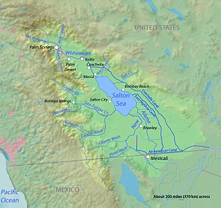
The Salton Sink is the low point of an endorheic basin, a closed drainage system with no outflows to other bodies of water, in the Colorado Desert sub-region of the Sonoran Desert. The sink falls within the larger Salton Trough and separates the Coachella Valley from the Imperial Valley, which are also segments of the Salton Trough. The lowest point of the sink is 269 ft (82 m) below sea level, and since 1906 the 343-square-mile (890 km2) Salton Sea has filled the lowest portion of the sink to a water depth of up to 43 ft (13 m).

The Alamo River flows west and north from the Mexicali Valley across the Imperial Valley (California). The 52-mile-long (84 km) river drains into the Salton Sea.
The California Development Company was formed in 1896 as a replacement for the defunct Colorado River Irrigation Company, which had been started a few years earlier for the purpose of planning an irrigation system for the lower Colorado Desert in California. The rich, silty soil of the area was found to be suitable for agriculture, but wells tapping groundwater brought up an inadequate supply of water for such a hot, arid region. The California Development Company took over the project of diverting Colorado River water into the Coachella and Imperial Valleys in the Salton Sink, a dry lake bed which today contains the Salton Sea, hoping to turn the desert green with agricultural fields. The first canals were being constructed by 1900 under the guidance of chief engineer George Chaffey.
The Imperial Irrigation District (IID) is an irrigation district that serves the Imperial Valley and a large portion of the Coachella Valley in the Colorado Desert region of Southern California. Established under the State Water Code, the IID supplies roughly 500,000 acres (200,000 ha) of Imperial Valley farmland with raw Colorado River water to support irrigation. IID also supplies electrical energy to the Imperial and Coachella valleys.

The deserts of California are the distinct deserts that each have unique ecosystems and habitats. The deserts are home to a sociocultural and historical "Old West" collection of legends, districts, and communities, and they also form a popular tourism region of dramatic natural features and recreational development. Part of this region was even proposed to become a new county due to cultural, economic and geographic differences relative to the rest of the more urban region.

The Salton Trough is an active tectonic pull-apart basin, or graben. It lies within the Imperial, Riverside, and San Diego counties of southeastern California and extends south of the Mexico–United States border into the state of Baja California.
The Coachella Valley Water District is an independent special district formed in 1918, specifically to protect and conserve local water sources in the Coachella Valley. Since then, the district has grown into a multi-faceted agency that delivers irrigation and domestic (drinking) water, collects and recycles wastewater, provides regional storm water protection, replenishes the groundwater basin and promotes water conservation.
The Colorado River Board of California is a state agency in the U.S. state of California that represents California in discussions and negotiations regarding the Colorado River and its management.

The Palo Verde Valley is located in the Lower Colorado River Valley, next to the eastern border of Southern California with Arizona, United States. It is located on the Colorado Desert within the Sonoran Desert south of the Parker Valley. Most of the valley is in Riverside County, with the southern remainder in Imperial County. La Paz County borders to the east on the Colorado River.

The Colorado River is a major river of the western United States and northwest Mexico in North America. Its headwaters are in the Rocky Mountains where La Poudre Pass Lake is its source. Located in north central Colorado it flows southwest through the Colorado Plateau country of western Colorado, southeastern Utah and northwestern Arizona where it flows through the Grand Canyon. It turns south near Las Vegas, Nevada, forming the Arizona–Nevada border in Lake Mead and the Arizona–California border a few miles below Davis Dam between Laughlin, Nevada and Needles, California before entering Mexico in the Colorado Desert. Most of its waters are diverted into the Imperial Valley of Southern California. In Mexico its course forms the boundary between Sonora and Baja California before entering the Gulf of California. This article describes most of the major features along the river.

Flora of the Colorado Desert, located in Southern California. The Colorado Desert is a sub-region in the Sonoran Desert ecoregion of southwestern North America. It is also known as the Low Desert, in contrast to the higher elevation Mojave Desert or High Desert, to its north.

Lake Cahuilla was a prehistoric lake in California and northern Mexico. Located in the Coachella and Imperial valleys, it covered surface areas of 5,700 km2 (2,200 sq mi) to a height of 12 m (39 ft) above sea level during the Holocene. During earlier stages of the Pleistocene, the lake reached even higher elevations, up to 31–52 m (102–171 ft) above sea level. During the Holocene most of the water came from the Colorado River with little contribution from local runoff; in the Pleistocene local runoff was higher and it is possible that Lake Cahuilla was supported solely from local water sources during the Wisconsin glaciation. The lake overflowed close to Cerro Prieto into the Rio Hardy, eventually draining into the Gulf of California.
Borrego Valley Groundwater Basin, located in the very southern region of California, is one of the driest basins in the state. With climate change predicted to have strong effects into foreseeable future, the region is viewed with a skepticism in the sustainable use of water at current rates of consumption. Both natural and man-made geographic divisions within this basin allow for a closer inspection of the various management techniques implemented throughout the years, and provide a basis for what may be pursued for an uncertain future.
