Guatemala City, formally New Guatemala of Assumption and the Ancient, known locally as Guate, is the capital and largest city of Guatemala, and the most populous urban area in Central America. The city is located in the south-central part of the country, nestled in a mountain valley called Valle de la Ermita. The city is also the capital of the Guatemala Department.
Chimaltenango is a city in Guatemala with a population of 96,985. It serves as both the capital of the department of Chimaltenango and the municipal seat for the surrounding municipality of the same name. Chimaltenango stands some 56 kilometres (35 mi) west of Guatemala City, on the Pan-American Highway. The municipal capital produces textiles and pottery.

Antigua Guatemala, commonly known as Antigua or La Antigua, is a city in the central highlands of Guatemala. The city was the capital of the Captaincy General of Guatemala from 1543 through 1773, with much of its Baroque-influenced architecture and layout dating from that period. These characteristics had it designated as a UNESCO World Heritage Site in 1979. Antigua Guatemala serves as the capital of the homonymous municipality and the Sacatepéquez Department.

Ciudad Victoria is the seat of the Municipality of Victoria, and the capital of the Mexican state of Tamaulipas. It is located in the northeast of Mexico at the foot of the Sierra Madre Oriental. It borders the municipality of Güémez to the north, Llera to the south, Casas Municipality to the east, and the municipality of Jaumave to the west. The city is located 246 km (153 mi) from Monterrey and 319 km (198 mi) from the US - Mexico border. Ciudad Victoria is named after the first president of Mexico, Guadalupe Victoria.

Jutiapa is a city and a municipality in the Jutiapa department of Guatemala.

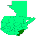
Jutiapa Department is a department of Guatemala that borders along El Salvador and the Pacific Ocean. The capital is the city of Jutiapa. As of 2018, it has a population of 488,395. The department is divided into seventeen municipalities. Jutiapa is the country's southeasternmost department and officially the only department with no Mayan descendants native to the region. The main crops are sorghum, tobacco, onion and corn. The climate is dry. An important attraction is the cattle fair. It is at 405 m above sea level.
San Marcos (elevation: 7,868 feet is a city and municipality in Guatemala. It is the capital of the department of San Marcos. The municipality has a population of 47,063.

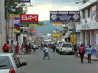
Chichicastenango, also known as Santo Tomás Chichicastenango, is a town, with a population of 71,394, and the municipal seat for the surrounding municipality of the same name in the El Quiché department of Guatemala. It is located in a mountainous region about 140 km (87 mi) northwest of Guatemala City, at an altitude of 1,965 m (6,447 ft). The Spanish conquistadors gave the town its name from the Nahuatl name used by their allied soldiers from Tlaxcala: Tzitzicaztenanco, or City of Nettles. Its original name was Chaviar.

San Pedro Carchá, usually referred to as Carchá, is a town, with a population of 16,353, and a municipality in the Guatemalan department of Alta Verapaz. It is situated at 1282 m above sea level. The municipality has a population of 235,275 and covers an area of 1310 km2.
Santa Lucía Milpas Altas is a town and municipality in the Guatemalan department of Sacatepéquez. The town has a population of 12,234.
Nentón is a town and municipality in the Guatemalan department of Huehuetenango. Its territory extends 717 km2 with a population of 45,679. It became a municipality on December 5, 1876 and was formerly known as San Benito Nentón. The population speaks Spanish and Chuj.
Masagua is a town, with a population of 16,797, and a municipality in the Escuintla department of Guatemala. In 2008 began construction for a massive power generation plant se property of Jaguar Energy in the municipality.
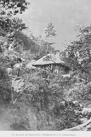
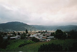
Chinautla is a city and municipality in the Guatemala department of Guatemala. The city has a population of 104,972 making it the fourteenth largest city in the country and the seventh largest in the Guatemala Department.

Mixco is a city and municipality in the Guatemala department of Guatemala. It is next to the main Guatemala City municipality and has become part of the Guatemala City Metropolitan Area. Most of Mixco is separated from the City by canyons, for which a multitude of bridges have been created. It is the second largest city in Guatemala after Guatemala City, with a population of 475,777. Ciudad San Cristóbal is located within Mixco.
Champerico is a town and municipality in the Retalhuleu department in southwestern Guatemala. It is a popular vacation spot for Guatemalans in the region. The picturesque beach town was founded on the Pacific Ocean in 1872, and the paved road to Retalhuleu makes Champerico one of the most important ports on the Pacific. The port handles mostly coffee, timber and sugar. Its population in 2023 is 39,666.
Guatemala, officially the Republic of Guatemala, is a country in Central America. It is bordered to the north and west by Mexico, to the northeast by Belize, to the east by Honduras, and to the southeast by El Salvador. It is touched to the south by the Pacific Ocean and to the northeast by the Gulf of Honduras. With an estimated population of around 17.6 million, Guatemala is the most populous country in Central America and the 11th most populous country in the Americas. It is a representative democracy with its capital and largest city being Nueva Guatemala de la Asunción, also known as Guatemala City, the most populous city in Central America.
Comapa is a municipality in the Mexican state of Veracruz, located about 40 kilometres (25 mi) south of the state capital Xalapa.