
The Mutawintji National Park, formerly the Mootwingee National Park, is a protected national park that is located in the Far West region of New South Wales, in eastern Australia. The 68,912-hectare (170,290-acre) national park is situated approximately 880 kilometres (550 mi) west of Sydney and about 130 kilometres (81 mi) north-east of Broken Hill.

Hell Hole Gorge is a national park in South West Queensland, Australia, 912 km west of Brisbane. It is characterized by steep cliffs up to 45 meters high along the Powell Creek and Spencer Creek. Notable waterholes are the Hell Hole Waterhole and Spencer's Waterhole. A campground offering primitive camping is available, no potable water is available on site. Access is by four wheel drive vehicles.

The Diamantina River is a major river located in Central West Queensland and the far north of South Australia.
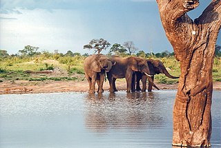
Hwange National Park is the largest natural reserve in Zimbabwe. It is around 14,600 sq km in area. It lies in the northwest of the country, just off the main road between Bulawayo and Victoria Falls. The nearest town is Dete. Histories of the region's pre-colonial days and its development as a game reserve and National Park are available online

Deep Creek National Park, formerly the Deep Creek Conservation Park, is a protected area in the Australian state of South Australia located on the southern coast of Fleurieu Peninsula in the gazetted localities of Deep Creek and Delamere about 11 kilometres east of Cape Jervis.

Spring Gully Conservation Park, formerly the Spring Gully National Park), is a protected area located in the Australian state of South Australia in the localities of Sevenhills and Spring Gully about 6 kilometres (3.7 mi) south of the town centre in Clare.

The Kennedy Highway is a highway in northern Queensland, Australia. It runs as National Route 1 for approximately 243 km from Smithfield, on the northern outskirts of Cairns, to the Gulf Developmental Road in the vicinity of Forty Mile Scrub and Undara Volcanic national parks. South of this junction, the road continues as the Kennedy Developmental Road to Boulia about 936 kilometres away, via Hughenden. West of the junction, National Route 1 continues as the Gulf Developmental Road to Normanton.

Dinosaur Stampede National Monument at Lark Quarry Conservation Park in Australia is considered to be the site of the world's only known record of a dinosaur stampede, with fossilised footprints are interpreted as a predator stalking and causing a stampede of around 150 two-legged dinosaurs. This interpretation has been challenged in recent years, with evidence suggesting it may have been a natural river crossing. The fossils date to either the Albian or Turonian periods between 104 to 92 million years ago, and are part of the Winton Formation sandstone. In 2015 Winton Shire Council invited the Australian Age of Dinosaurs Museum of Natural History to take over the operation of public guided tours at Dinosaur Stampede National Monument. This joint initiative, implemented in April 2016, provides visitors with a broader understanding of unique Australian dinosaurs and the world they inhabited. In 2018 Dinosaur Stampede National Monument received 14,180 visitors.

The Belyando River, including the Belyando River , is a river system located in Central Queensland, Australia. At 1,054 kilometres (655 mi) in length and with a catchment area of 35,000 square kilometres (14,000 sq mi), the Belyando River system is one of the longest rivers in Queensland.
The Nambung River is a river in the Wheatbelt region of Western Australia, 170 kilometres (106 mi) north of Perth. The river drains an area between the towns of Cervantes and Badgingarra. In its lower reaches the Nambung River forms a chain of waterholes in the Nambung Wetlands where it disappears underground into a limestone karst system 5.5 kilometres (3 mi) from the Indian Ocean.

Dagworth Station is a cattle station located north-west of Winton in central west Queensland in Australia. It was established in 1876 by Messrs Hunter and Urquhart who were living in a grass hut on the property in 1878 when they were still building up the run. One of the adjoining properties in 1887 was Elderslie Station, which at the time was owned by Sir Samuel Wilson.
Kynuna is an outback town in the Shire of McKinlay and a locality split between the Shire of McKinlay and the Shire of Winton in Queensland, Australia. In the 2016 census the locality of Kynuna had a population of 55 people.

Lathami Conservation Park is a protected area in the Australian state of South Australia on the north coast of Kangaroo Island located in the locality of Cassini about 1 kilometre east of Stokes Bay and about 17 kilometres north of Parndana. It was proclaimed on 1 October 1987 to protect important nesting and foraging habitat for the Glossy Black Cockatoo, after which the conservation park was named.

The Settlement Creek is a creek located in the Northern Territory and the state of Queensland, Australia.

Calca is a small township around 20 kilometres (12 mi) south-east of Streaky Bay, on the southern border of the Calpatanna Waterhole Conservation Park, Eyre Peninsula.
Collingwood is a former town in the Channel Country in Central West Queensland, Australia, in the Shire of Winton. Collingwood was founded in the 1870s, and it was hoped that the town would thrive and grow into a regional centre that would foster the development of pastoral activity in the Diamantina region, an industry of great local importance to this day. However, Collingwood ultimately failed as a town and was given up after only about two decades of existence.
Calpatanna Waterhole Conservation Park is a protected area in the Australian state of South Australia located on the Eyre Peninsula in the gazetted localities of Calca, Mortana and Yanerbie about 25 kilometres (16 mi) south-east of the town centre in Streaky Bay.
Tilley Swamp is a locality in the Australian state of South Australia located in the state's south-east about 199 kilometres (124 mi) south-east of the state capital of Adelaide and about 55 kilometres (34 mi) north of the municipal seat of Kingston SE. The 2016 Australian census, which was conducted in August 2016, reports that the area had a population of 27 people.
Elliott is a rural locality in the Bundaberg Region, Queensland, Australia. In the 2016 census, Elliott had a population of 138 people.

The Frew River is an ephemeral river in the Northern Territory of Australia.
