The following is a list of the 891 communes of the Pas-de-Calais department of France.
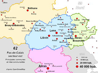
The Communauté d'agglomération de Lens – Liévin is the communauté d'agglomération, an intercommunal structure, centred on the cities of Lens and Liévin. It is located in the Pas-de-Calais department, in the Hauts-de-France region, northern France. It was created in January 2000. It adopted the name Communaupole on June 25, 2004. Its population was 245,048 in 2014, of which 31,875 in Lens and 32,021 in Liévin.
Évreux Portes de Normandie is the communauté d'agglomération, an intercommunal structure, centred on the city of Évreux. It is located in the Eure department, in the Normandy region, northern France. It was created on 1 January 2017 by the merger of the former Communauté d'agglomération d'Évreux and the Communauté de communes La porte normande. On 1 January 2018 it was expanded with 12 communes from three other intercommunalities. Its population was 116,341 in 2015, of which 52,168 in Évreux proper.
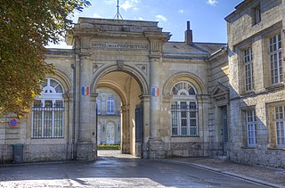
The Communauté d'agglomération du Boulonnais is the communauté d'agglomération, an intercommunal structure, centred on the city of Boulogne-sur-Mer. It is located in the Pas-de-Calais department, in the Hauts-de-France region, northern France. It was created in January 2000. Its population was 118,623 in 2014, of which 43,170 in Boulogne-sur-Mer proper.

The Agglomération du Choletais, also simply known as CAC, is the intercommunal structure gathering the city of Cholet and its suburbs.

The Communauté d'agglomération Saumur Val de Loire is an intercommunal structure in the Loire Valley gathering 47 communes including Saumur and Montsoreau. It is located in the Maine-et-Loire département, in the Pays de la Loire région, western France. It was formed on 1 January 2017 by the merger of the former Communauté d'agglomération de Saumur Loire Développement, the Communauté de communes Loire Longué, the Communauté de communes du Gennois and the Communauté de communes de la région de Doué-la-Fontaine.
Vitré Communauté is the communauté d'agglomération, an intercommunal structure, centred on the town of Vitré. It is located in the Ille-et-Vilaine department, in the Bretagne region, northwestern France. It was created in 2002. Its population was 81,467 in 2014, of which 18,171 in Vitré proper. It has an area of 880 km2.

The Boulonnais is a coastal area of northern France, around Calais and Boulogne-sur-Mer. It has a curved belt of chalk downs which run into the sea at both ends, and geologically is the east end of the Weald-Artois Anticline.
The Communauté de communes du Pays Fertois is a former federation of municipalities in the Seine-et-Marne département and in the Île-de-France région of France. It was merged into the new Communauté d'agglomération Coulommiers Pays de Brie in January 2018.
The canton of Berck is a canton situated in the Pas-de-Calais département and in the Hauts-de-France region of France.
The communauté de communes du Montreuillois was created on July 12, 1999 and was located in the Pas-de-Calais département, in northern France. It was merged into the new Communauté d'agglomération des Deux Baies en Montreuillois in January 2017.
The Communauté d'agglomération du Grand Guéret was created on December 15, 1992 as communauté de communes de Guéret Saint-Vaury and is located in the Creuse département of the Nouvelle-Aquitaine region, central France. In January 2013 it absorbed three more communes, and became a communauté d'agglomération. In 2018 it absorbed three communes from the Communauté de communes Creuse Sud Ouest.
The Communauté d'agglomération de Fécamp Caux Littoral is the communauté d'agglomération, an intercommunal structure, centred on the town of Fécamp. It is located in the Seine-Maritime department, in the Normandy region, northern France. It was created on 1 January 2015 from the former communauté de communes de Fécamp. It absorbed the former Communauté de communes du Canton de Valmont on 1 January 2017. Its population was 40,358 in 2015, of which 19,591 in Fécamp proper. Its seat is in Fécamp.
The Communauté de communes Terroir de Caux is a communauté de communes in the Seine-Maritime département and in the Normandy région of France. It was formed on 1 January 2017 by the merger of the former Communauté de communes des Trois Rivières, Communauté de Communes Saâne et Vienne, Communauté de communes de Varenne et Scie and 3 communes from the former Communauté de communes du Bosc d'Eawy on 1 January 2017. Its seat is in Bacqueville-en-Caux.
The Communauté d'agglomération Roissy Pays de France is a communauté d'agglomération in the Val-d'Oise and Seine-et-Marne départements and in the Île-de-France région of France. It was formed on 1 January 2016 by the merger of the former communauté d'agglomération Val de France, communauté d'agglomération Roissy Porte de France and 17 communes that were part of the Communauté de communes Plaines et Monts de France. Its seat is in Roissy-en-France. Its population was 349,490 in 2014, of which 2,881 in Roissy-en-France and 57,455 in Sarcelles, the largest commune of the communauté d'agglomération.
The Communauté urbaine Grand Paris Seine et Oise is the communauté urbaine, an intercommunal structure, covering the western suburbs of Paris. It is located in the Yvelines department, in the Île-de-France region, northern France. It was created in January 2016 by the merger of the previous communautés d'agglomération Mantes-en-Yvelines, Deux Rives de la Seine, Poissy-Achères-Conflans-Sainte-Honorine, Seine & Vexin and the communautés de communes Coteaux du Vexin and Seine-Mauldre. Its population was 411,100 in 2014. Its seat is in Aubergenville.
Communauté d'agglomération Plaine Vallée is the communauté d'agglomération, an intercommunal structure, covering northwestern suburbs of Paris. It is located in the Val-d'Oise department, in the Île-de-France region, northern France. It was created in January 2016. Its population was 183,063 in 2014. Its seat is in Montmorency.
Communauté d'agglomération Troyes Champagne Métropole is the communauté d'agglomération, an intercommunal structure, centred on the city of Troyes. It is located in the Aube department, in the Grand Est region, northeastern France. It was created in January 2017 by the merger of the former Communauté d'agglomération du Grand Troyes with 3 former communautés de communes and 6 other communes. Its population was 172,967 in 2014, of which 62,204 in Troyes proper.
Communauté d'agglomération Lisieux Normandie is the communauté d'agglomération, an intercommunal structure, centred on the town of Lisieux. It is located in the Calvados department, in the Normandy region, northwestern France. It was created in January 2017 by the merger of the former communautés de communes Lintercom Lisieux - Pays d'Auge - Normandie, Vallée d'Auge, Trois Rivières, Pays de Livarot and Pays de l'Orbiquet. It was expanded with six communes from the former communautés de communes de Cambremer in January 2018. Its population was 77,871 in 2015. Its seat is in Lisieux.
The Communauté d'agglomération Coulommiers Pays de Brie is the communauté d'agglomération, an intercommunal structure, centred on the town of Coulommiers. It is located in the Seine-et-Marne department, in the Île-de-France region, north-central France. It was created in January 2018 by the merger of the former Communauté de communes du Pays de Coulommiers and the Communauté de communes du Pays Fertois. Its population was 76,612 in 2015, of which 15,476 in Coulommiers.