Communauté urbaine du Grand Reims

Last updated

The Communauté urbaine du Grand Reims is the communauté urbaine , an intercommunal structure, centred on the city of Reims. It is located in the Marne department, in the Grand Est region, northeastern France. It was created in January 2017 by the merger of the previous communauté d'agglomération Reims Métropole with the communautés de communes Beine-Bourgogne, Champagne Vesle, Nord Champenois, Fismes Ardre et Vesle, Vallée de la Suippe, Rives de la Suippe, Vesle et Coteaux de la Montagne de Reims and 18 other communes. [1] Its population was 299,054 in 2014, of which 186,971 in Reims proper. [2]

Communauté urbaine is the second most integrated form of intercommunality in France, after the Metropolis. A communauté urbaine is composed of a city (commune) and its independent suburbs.

The commune is a level of administrative division in the French Republic. French communes are analogous to civil townships and incorporated municipalities in the United States and Canada, Gemeinden in Germany, comuni in Italy or ayuntamiento in Spain. The United Kingdom has no exact equivalent, as communes resemble districts in urban areas, but are closer to parishes in rural areas where districts are much larger. Communes are based on historical geographic communities or villages and are vested with significant powers to manage the populations and land of the geographic area covered. The communes are the fourth-level administrative divisions of France.

Reims Subprefecture and commune in Grand Est, France

Reims, a city in the Grand Est region of France, lies 129 km (80 mi) east-northeast of Paris. The 2013 census recorded 182,592 inhabitants in the city of Reims proper, and 317,611 inhabitants in the metropolitan area. Its primary river, the Vesle, is a tributary of the Aisne.

Composition

The communauté urbaine consists of the following 143 communes: [2] [3]

  1. Anthenay
  2. Aougny
  3. Arcis-le-Ponsart
  4. Aubérive
  5. Aubilly
  6. Auménancourt
  7. Baslieux-lès-Fismes
  8. Bazancourt
  9. Beaumont-sur-Vesle
  10. Beine-Nauroy
  11. Berméricourt
  12. Berru
  13. Bétheniville
  14. Bétheny
  15. Bezannes
  16. Billy-le-Grand
  17. Bligny
  18. Bouilly
  19. Bouleuse
  20. Boult-sur-Suippe
  21. Bourgogne-Fresne
  22. Bouvancourt
  23. Branscourt
  24. Breuil
  25. Brimont
  26. Brouillet
  27. Caurel
  28. Cauroy-lès-Hermonville
  29. Cernay-lès-Reims
  30. Châlons-sur-Vesle
  31. Chambrecy
  32. Chamery
  33. Champfleury
  34. Champigny
  35. Chaumuzy
  36. Chenay
  37. Chigny-les-Roses
  38. Cormicy
  39. Cormontreuil
  40. Coulommes-la-Montagne
  41. Courcelles-Sapicourt
  42. Courcy
  43. Courlandon
  44. Courmas
  45. Courtagnon
  46. Courville
  47. Crugny
  48. Cuisles
  49. Dontrien
  50. Écueil
  51. Époye
  52. Faverolles-et-Coëmy
  53. Fismes
  54. Germigny
  55. Gueux
  56. Hermonville
  57. Heutrégiville
  58. Hourges
  59. Isles-sur-Suippe
  60. Janvry
  61. Jonchery-sur-Vesle
  62. Jonquery
  63. Jouy-lès-Reims
  64. Lagery
  65. Lavannes
  66. Lhéry
  67. Loivre
  68. Ludes
  69. Magneux
  70. Mailly-Champagne
  71. Marfaux
  72. Merfy
  73. Méry-Prémecy
  74. Les Mesneux
  75. Montbré
  76. Montigny-sur-Vesle
  77. Mont-sur-Courville
  78. Muizon
  79. Nogent-l'Abbesse
  80. Olizy
  81. Ormes
  82. Pargny-lès-Reims
  83. Les Petites-Loges
  84. Pévy
  85. Poilly
  86. Pomacle
  87. Pontfaverger-Moronvilliers
  88. Pouillon
  89. Pourcy
  90. Prosnes
  91. Prouilly
  92. Prunay
  93. Puisieulx
  94. Reims
  95. Rilly-la-Montagne
  96. Romain
  97. Romigny
  98. Rosnay
  99. Sacy
  100. Saint-Brice-Courcelles
  101. Saint-Étienne-sur-Suippe
  102. Saint-Euphraise-et-Clairizet
  103. Saint-Gilles
  104. Saint-Hilaire-le-Petit
  105. Saint-Léonard
  106. Saint-Martin-l'Heureux
  107. Saint-Masmes
  108. Saint-Souplet-sur-Py
  109. Saint-Thierry
  110. Sarcy
  111. Savigny-sur-Ardres
  112. Selles
  113. Sept-Saulx
  114. Sermiers
  115. Serzy-et-Prin
  116. Sillery
  117. Taissy
  118. Thil
  119. Thillois
  120. Tinqueux
  121. Tramery
  122. Trépail
  123. Treslon
  124. Trigny
  125. Trois-Puits
  126. Unchair
  127. Val-de-Vesle
  128. Vandeuil
  129. Vaudemange
  130. Vaudesincourt
  131. Ventelay
  132. Verzenay
  133. Verzy
  134. Ville-Dommange
  135. Ville-en-Selve
  136. Ville-en-Tardenois
  137. Villers-Allerand
  138. Villers-aux-Nœuds
  139. Villers-Franqueux
  140. Villers-Marmery
  141. Vrigny
  142. Warmeriville
  143. Witry-lès-Reims

Related Research Articles

Marne (department) Department of France

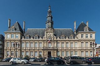
Marne is a department in north-eastern France named after the river Marne which flows through the department. The prefecture (capital) of Marne is Châlons-en-Champagne. The subprefectures are Épernay, Reims, and Vitry-le-François.

Vesle river in France

The Vesle is the river on which the city of Reims stands. It is a fourth order river of France and a left-bank tributary of the Aisne. It is 140 kilometres long, rises in the département of Marne through which it flows most of its course.

Arrondissement of Châlons-en-Champagne Arrondissement in Grand Est, France

The arrondissement of Châlons-en-Champagne is an arrondissement of France in the Marne department in the Grand Est region. Since the April 2017 reorganization of the arrondissements of Marne, it has 150 communes.

Arrondissement of Reims Arrondissement in Grand Est, France

The arrondissement of Reims is an arrondissement of France in the Marne department in the Grand Est region. In 2006 it lost the canton of Aÿ to the arrondissement of Épernay. Since the April 2017 reorganization of the arrondissements of Marne, it has 143 communes.

Arrondissement of Soissons Arrondissement in Hauts-de-France, France

The arrondissement of Soissons is an arrondissement of France in the Aisne department in the Hauts-de-France region. Since the January 2017 reorganization of the arrondissements of Aisne, it has 166 communes.

Arrondissement of Briey Arrondissement in Grand Est, France

The arrondissement of Briey is an arrondissement of France in the Meurthe-et-Moselle department in the Grand Est region. It has 128 communes.

Arrondissement of Dole Arrondissement in Bourgogne-Franche-Comté, France

The arrondissement of Dole is an arrondissement of France in the Jura department in the Bourgogne-Franche-Comté region. Since the January 2017 reorganization of the arrondissements of Jura, it has 191 communes.

The following is a list of the 23 cantons of the Marne department, in France, following the French canton reorganisation which came into effect in March 2015:

Ardre (river) river in France

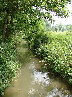
The Ardre is a fifth order river in France which flows into the Vesle thence into the Aisne, Oise and Seine.

The Communauté de communes du Sud-Ouest Amiénois is a former communauté de communes in the Somme département and in the Picardie région of France. It was merged into the new Communauté de communes Somme Sud-Ouest in January 2017.

The canton of Fère-en-Tardenois is an administrative division in northern France. At the French canton reorganisation which came into effect in March 2015, the canton was expanded from 23 to 84 communes :

Montagne de Reims Regional Natural Park Regional park of France in Grand Est, France

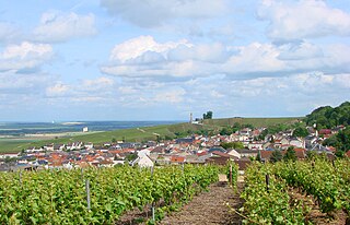
Montagne de Reims Regional Natural Park is a protected area in the Grand Est region of France. It is organized around the Montagne de Reims, a wooded range of hills covered by vineyards that produce the region's eponymous sparkling wine, Champagne.

Arrondissement of Metz Arrondissement in Grand Est, France

The arrondissement of Metz is an arrondissement of France in the Moselle department in the Grand Est region. It was created at the 2015 arrondissements reform by the merger of the former arrondissements of Metz-Campagne and Metz-Ville. It has 140 communes.

The Communauté de communes Somme-Sud-Ouest is a communauté de communes in the Somme département and in the Hauts-de-France région of France. It was formed on 1 January 2017 by the merger of the former Communauté de communes du Contynois, the Communauté de communes de la Région d'Oisemont and the Communauté de communes du Sud-Ouest Amiénois. It consists of 121 communes, and its seat is in Poix-de-Picardie.

The canton of Bourgogne is an administrative division of the Marne department, northeastern France. Its borders were modified at the French canton reorganisation which came into effect in March 2015. Its seat is in Bourgogne-Fresne.

The canton of Argonne Suippe et Vesle is an administrative division of the Marne department, northeastern France. It was created at the French canton reorganisation which came into effect in March 2015. Its seat is in Sainte-Menehould.

The canton of Fismes-Montagne de Reims is an administrative division of the Marne department, northeastern France. It was created at the French canton reorganisation which came into effect in March 2015. Its seat is in Fismes.

The canton of Mourmelon-Vesle et Monts de Champagne is an administrative division of the Marne department, northeastern France. It was created at the French canton reorganisation which came into effect in March 2015. Its seat is in Mourmelon-le-Grand.

The Communauté urbaine Grand Paris Seine et Oise is the communauté urbaine, an intercommunal structure, covering the western suburbs of Paris. It is located in the Yvelines department, in the Île-de-France region, northern France. It was created in January 2016 by the merger of the previous communautés d'agglomération Mantes-en-Yvelines, Deux Rives de la Seine, Poissy-Achères-Conflans-Sainte-Honorine, Seine & Vexin and the communautés de communes Coteaux du Vexin and Seine-Mauldre. Its population was 411,100 in 2014. Its seat is in Aubergenville.

References

  1. Arrêté préfectoral, 13 December 2016, p 20-23
  2. 1 2 BANATIC, Périmètre des EPCI à fiscalité propre. Accessed 2017-06-28.
  3. INSEE

Coordinates: 49°15′N4°02′E / 49.25°N 4.03°E / 49.25; 4.03

Geographic coordinate system Coordinate system

A geographic coordinate system is a coordinate system that enables every location on Earth to be specified by a set of numbers, letters or symbols. The coordinates are often chosen such that one of the numbers represents a vertical position and two or three of the numbers represent a horizontal position; alternatively, a geographic position may be expressed in a combined three-dimensional Cartesian vector. A common choice of coordinates is latitude, longitude and elevation. To specify a location on a plane requires a map projection.