
Aisne is a French department in the Hauts-de-France region of northern France. It is named after the river Aisne.

Val-de-Marne is a French department, named after the Marne River, located in the Île-de-France region. The department is situated to the southeast of the city of Paris and in the Grand Paris.

The Second Battle of the Marne was the last major German offensive on the Western Front during the First World War. The attack failed when an Allied counterattack, supported by several hundred tanks, overwhelmed the Germans on their right flank, inflicting severe casualties. The German defeat marked the start of the relentless Allied advance which culminated in the Armistice with Germany about 100 days later.

Fère-en-Tardenois is a commune in the Aisne department in Hauts-de-France in northern France.

The arrondissement of Reims is an arrondissement of France in the Marne department in the Grand Est region. It has 143 communes. Its population is 294,674 (2016), and its area is 1,432.4 km2 (553.1 sq mi).

The arrondissement of Château-Thierry is an arrondissement of France in the Aisne department in the Hauts-de-France region. It has 108 communes. Its population is 69,836 (2016), and its area is 1,115.2 km2 (430.6 sq mi).

Champs-sur-Marne is a commune in the eastern suburbs of Paris, France. It is located 18.2 km (11.3 mi) from the center of Paris, in the Seine-et-Marne Departments of France in the Île-de-France region.
The following is a list of the 21 cantons of the Aisne department, in France, following the French canton reorganisation which came into effect in March 2015:

Azy-sur-Marne is a commune in the department of Aisne in the Hauts-de-France region of northern France.

Barzy-sur-Marne is a commune in the department of Aisne in the Hauts-de-France region of northern France.

Fresnes-en-Tardenois is a commune in the Aisne department in Hauts-de-France in northern France.

Angluzelles-et-Courcelles is a commune in the Marne department in northeastern France.

Dormans is a commune located in the Marne department and in the Grand Est region of France.
The canton of Fère-en-Tardenois is an administrative division in northern France. At the French canton reorganisation which came into effect in March 2015, the canton was expanded from 23 to 84 communes :

The Ourcq is an 86.5-kilometre-long (53.7 mi) river in France, a right tributary of the Marne. Its source is near the village Ronchères, and its course crosses the departments of Aisne, Oise, and Seine-et-Marne. It flows southwest through the towns of Fère-en-Tardenois, La Ferté-Milon, Mareuil-sur-Ourcq, and Crouy-sur-Ourcq, finally flowing into the Marne near Lizy-sur-Ourcq. Napoleon I made use of the river as a water source, and it supplied the city of Paris until Baron Haussmann's rebuilding of Paris.
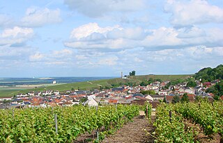
Montagne de Reims Regional Natural Park is a protected area in the Grand Est region of France. It is organized around the Montagne de Reims, a wooded range of hills covered by vineyards that produce the region's eponymous sparkling wine, Champagne.

The 2nd constituency of Marne is one of five electoral districts in the department of the same name, each of which returns one deputy to the French National Assembly in elections using the two-round system, with a run-off if no candidate receives more than 50% of the vote in the first round.

The Tardenois is today a natural region of France. It is known among archeologists for the epipaleolithic culture known as Tardenoisian after its characteristic arrowheads, originally found at Coincy in the Tardenois in 1885. The etymology of "Tardenois" is not known.
The canton of Dormans-Paysages de Champagne is an administrative division of the Marne department, northeastern France. It was created at the French canton reorganisation which came into effect in March 2015. Its seat is in Dormans.

The Communauté urbaine du Grand Reims is the communauté urbaine, an intercommunal structure, centred on the city of Reims. It is located in the Marne department, in the Grand Est region, northeastern France. It was created on 1 January 2017 by the merger of the previous communauté d'agglomération Reims Métropole with the communautés de communes Beine-Bourgogne, Champagne Vesle, Nord Champenois, Fismes Ardre et Vesle, Vallée de la Suippe, Rives de la Suippe, Vesle et Coteaux de la Montagne de Reims and 18 other communes. Its population was estimated to be 300,699 in 2019, of which 187,074 lived in Reims proper.


