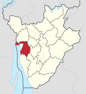
Bujumbura Rural Province is one of the 18 provinces of Burundi. Former President of Burundi Cyprien Ntaryamira was born here.

The arrondissement of Rethel is an arrondissement of France in the Ardennes department in the Grand Est region. It has 101 communes.

The arrondissement of Saverne is an arrondissement of France in the Bas-Rhin department in the Grand Est region. At the 2015 arrondissements reform it was expanded with several communes from the arrondissements of Strasbourg-Campagne, and some of its communes were reassigned to the arrondissements of Haguenau-Wissembourg and Molsheim. It has 162 communes.

Vajrakarur is a village in Anantapur district of the Indian state of Andhra Pradesh. It is the mandal headquarters of Vajrakarur mandal in Anantapur revenue division.
The canton of Soissons-2 is an administrative division in northern France. It consists of the southern part of the town of Soissons and its southern suburbs. At the French canton reorganisation which came into effect in March 2015, the canton was expanded from 11 to 14 communes:
Herăști is a commune located in Giurgiu County, Romania. It is composed of two villages, Herăști and Miloșești. Until 2004, these were part of Hotarele Commune, when they were split off to form a separate commune.
Livada is a commune in Arad County, Romania. Livada commune is situated on the Arad Plateau, northward from Arad. The commune stretches over 2013 hectares and is composed of two villages, Livada and Sânleani (Szentleányfalva).

Niedźwiedź is a village in the administrative district of Gmina Świecie, within Świecie County, Kuyavian-Pomeranian Voivodeship, in north-central Poland. It lies approximately 7 kilometres (4 mi) south-west of Świecie, 38 km (24 mi) north-east of Bydgoszcz, and 41 km (25 mi) north-west of Toruń.

Cherechiu is a commune in Bihor County, northwestern Romania with a population of 2,416 people. It is composed of three villages: Cherechiu, Cheșereu (Érkeserű) and Târgușor (Asszonyvására).
Viișoara is a commune in Bihor County, northwestern Romania with a population of 1,336 people. It is composed of four villages: Izvoarele (Szolnokháza), Pădureni (Erdőtelep), Reghea (Csekenye) and Viișoara.
Cungrea is a commune in Olt County, Romania. It is composed of seven villages: Cepești, Cungrea, Ibănești, Miești, Oteștii de Jos, Oteștii de Sus and Spătaru.
Deveselu is a commune in Olt County, Romania. It is composed of two villages, Comanca and Deveselu.
Tufeni is a commune in Olt County, Romania. It is composed of three villages: Barza, Stoborăști and Tufeni.
Janów Karwicki is a village in the administrative district of Gmina Opoczno, within Opoczno County, Łódź Voivodeship, in central Poland. It lies approximately 6 kilometres (4 mi) east of Opoczno and 77 km (48 mi) south-east of the regional capital Łódź.
Jastrzębniki is a village in the administrative district of Gmina Działoszyce, within Pińczów County, Świętokrzyskie Voivodeship, in south-central Poland. It lies approximately 3 kilometres (2 mi) east of Działoszyce, 22 km (14 mi) south-west of Pińczów, and 60 km (37 mi) south of the regional capital Kielce.
Gorzewnica is a village in the administrative district of Gmina Brochów, within Sochaczew County, Masovian Voivodeship, in east-central Poland. It lies approximately 10 kilometres (6 mi) north-east of Brochów, 19 km (12 mi) north-east of Sochaczew, and 46 km (29 mi) west of Warsaw.
Yên Mỹ is a commune (xã) and village in Lạng Giang District, Bắc Giang Province, in northeastern Vietnam.
Djigbé is a town and arrondissement in the Atlantique Department of southern Benin. It is an administrative division under the jurisdiction of the commune of Zè. According to the population census conducted by the Institut National de la Statistique Benin on February 15, 2002, the arrondissement had a total population of 3,671.

Ambatolampy is a district in Vakinankaratra Region, in Madagascar. The district is subdivided into 18 communes with a total population estimated at 256,164 in 2013.