This article is about communications systems in the Federated States of Micronesia.
The telecommunications and postal services market in Greece is regulated by the Hellenic Telecommunications and Post Commission (EETT).
Communications in Indonesia has a complex history due to the need to reach an extended archipelago of over 17,500 islands. The once important non-electronic communication methods of the past have given way to a considerable telecommunications infrastructure in contemporary Indonesia.

The Marshall Islands, officially the Republic of the Marshall Islands, is an island country west of the International Date Line and north of the equator in the Micronesia region in the Northwestern Pacific Ocean.

The Marshall Islands consist of two archipelagic island chains of 30 atolls and 1,152 islands, which form two parallel groups—the "Ratak" (sunrise) chain and the "Ralik" (sunset) chain. The Marshalls are located in the North Pacific Ocean and share maritime boundaries with Micronesia and Kiribati. Two-thirds of the nation's population lives in the capital of Majuro and the settlement of Ebeye. The outer islands are sparsely populated due to lack of employment opportunities and economic development.
Telecommunications in Namibia include radio, television, fixed and mobile telephones, and the Internet.
The People's Republic of China possesses a diversified communications system that links all parts of the country by Internet, telephone, telegraph, radio, and television. The country is served by an extensive system of automatic telephone exchanges connected by modern networks of fiber-optic cable, coaxial cable, microwave radio relay, and a domestic satellite system; cellular telephone service is widely available, expanding rapidly, and includes roaming service to foreign countries. Fiber to the x infrastructure has been expanded rapidly in recent years.
In South Korea, telecommunications services improved dramatically in the 1980s with the assistance of foreign partners and as a result of the development of the electronics industry. The number of telephones in use in 1987 reached 9.2 million, a considerable increase from 1980, when there were 2.8 million subscribers.
Telecommunications in Tonga include radio, television, telephones, and the Internet.
Telecommunications in Tuvalu cover Tuvalu's 6 atolls and 3 reef islands. The islands of Tuvalu rely on satellite dishes for communication and internet access.
Communications in the United States Virgin Islands
Communications in Barbados refers to the telephony, internet, postal, radio, and television systems of Barbados. Barbados has long been an informational and communications centre in the Caribbean region. Electricity coverage throughout Barbados is good and reliable. Usage is high and provided by a service monopoly, Barbados Light & Power Company Ltd..
Bermuda has three main television stations, a small cable microwave system, three public GSM services, multiple submarine cables, and two main Internet service providers.
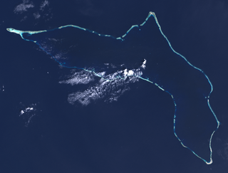
Kwajalein Atoll is part of the Republic of the Marshall Islands (RMI). The southernmost and largest island in the atoll is named Kwajalein Island, which its majority English-speaking residents often use the shortened name, Kwaj. The total land area of the atoll amounts to just over 6 square miles (16 km2). It lies in the Ralik Chain, 2,100 nautical miles southwest of Honolulu, Hawaii.

The American Forces Network (AFN) is a government television and radio broadcast service the U.S. military provides to those stationed or assigned overseas, and is headquartered at Fort Meade in Maryland. AFN comprises two subordinate overseas commands and one directorate in the continental United States. Overseas, AFN Europe is headquartered at Sembach Kaserne in Germany and consists of 15 subordinate stations in the countries of Bahrain, Belgium, Cuba, Germany, Greece, Italy, Spain, and Turkey. AFN Pacific is headquartered at Yokota Air Base in Japan and consists of nine stations in Diego Garcia, Japan, and South Korea. Stations under AFN Europe and AFN Pacific broadcast live local radio shows 12 hours a day Monday through Friday, with the exception of U.S. federal holidays. Stateside, AFN's broadcast operations, which include global radio and television satellite feeds, emanate from the AFN Broadcast Center/Defense Media Center at March Air Reserve Base in Riverside, California.

Ebeye is the populous island of Kwajalein Atoll in the Marshall Islands, and the second most populated in the Marshall Islands. It is a center for Marshallese culture in the Ralik Chain of the archipelago. Settled on 80 acres of land, it 2021 it had a population of 8,416. Over 50% of the population is estimated to be under the age of 18.

Air Marshall Islands is an airline based in Majuro, Marshall Islands. It is the flag carrier of the Marshall Islands, operating inter-island services in the Central Pacific. Its main base is Marshall Islands International Airport, Majuro.

The Ronald Reagan Ballistic Missile Defense Test Site, commonly referred to as the Reagan Test Site, is a missile test range in Marshall Islands. It covers about 750,000 square miles (1,900,000 km2) and includes rocket launch sites at the Kwajalein Atoll, Wake Island, and Aur Atoll. It primarily functions as a test facility for U.S. missile defense and space research programs. The Reagan Test Site is under the command of the US Army Kwajalein Atoll, or USAKA.
HANTRU-1 is a submarine communications cable system that connects the Reagan Test Site in the Kwajalein atoll to Guam. The cable was funded by $100 million from the US Army. Marshall Islands and Federated States of Micronesia arranged to add extensions to this trunk line for total of $30 million. It has cable landing points at:
The Marshalls Broadcasting Company (MBC) is the national broadcaster of the Marshall Islands. It operates one radio station, V7AB and one television channel.
