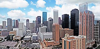
Dallas is the third-most populous city in Texas and the most populous city in the Dallas–Fort Worth metroplex, the fourth-largest metropolitan area in the United States at 7.5 million people. It is the largest city in and seat of Dallas County with portions extending into Collin, Denton, Kaufman, and Rockwall counties. With a 2020 census population of 1,304,379, it is the ninth-most populous city in the U.S. and the third-most populous city in Texas after Houston and San Antonio. Located in the North Texas region, the city of Dallas is the main core of the largest metropolitan area in the Southern United States and the largest inland metropolitan area in the U.S. that lacks any navigable link to the sea.

Fort Worth is the fifth-largest city in the U.S. state of Texas and the 13th-largest city in the United States. It is the county seat of Tarrant County, covering nearly 350 square miles (910 km2) into four other counties: Denton, Johnson, Parker, and Wise. According to a 2022 United States census estimate, Fort Worth's population was 956,709. Fort Worth is the second-largest city in the Dallas–Fort Worth–Arlington metropolitan area, which is the fourth-most populous metropolitan area in the United States, and the most populous in Texas.

Granbury is a city in and the county seat of Hood County, Texas, United States. As of the 2020 census, the city's population was 10,958, and it is the principal city of the Granbury micropolitan statistical area. Granbury is named after Confederate General Hiram B. Granbury.

Benbrook is a town located in the southwestern corner of Tarrant County, Texas, and a suburb of Fort Worth. As of the 2010 United States census, the population was 21,234, reflecting an increase of 1,026 from the 20,208 counted in the 2000 census, which had in turn increased by 644 from the 19,564 counted in the 1990 census.

Missouri City is a city in the U.S. state of Texas, within the Houston–The Woodlands–Sugar Land metropolitan area. The city is mostly in Fort Bend County, with a small portion in Harris County. As of the 2020 census, the city had a population of 74,259, up from 67,358 in 2010. The population was estimated at 75,457 in 2019.

Oak Cliff is a neighborhood of Dallas, Texas, that was formerly a separate town in Dallas County; Dallas annexed Oak Cliff on April 04, 1903. It has since retained a distinct neighborhood identity as one of Dallas' older established neighborhoods.
Stop Six is a neighborhood in south-east Fort Worth, Texas (USA).
Polytechnic Heights, known as Poly by locals, is a neighborhood of Fort Worth, Texas, located on the southeast side of the city. In 2016, the neighborhood had roughly 20,000 citizens. Texas Wesleyan University is located in Polytechnic Heights. Rosedale Street serves as the neighborhood's main roadway.

Handley was a town in Tarrant County, Texas United States. It is located between downtown Fort Worth and Arlington along State Highway 180, and includes the Central Handley Historic District. It is now a part of Fort Worth.

The geographic areas of Houston are generally classified as either being inside or outside Interstate 610, colloquially called "the Loop". The Loop generally encircles the central business district and the "island cities" of West University Place, Southside Place, and a portion of Bellaire.

West Dallas is an area consisting of many communities and neighborhoods in Dallas, Texas, United States. West Dallas is the area bounded by Interstate 30 on the south, the Trinity River on the east and north, and the Trinity River's West Fork on the west.

Fort Worth Independent School District is a school district based in Fort Worth, Texas, United States. Based on a 2017-18 enrollment of 86,234 students, it is the fifth largest school district in Texas.

New Orleans East is the eastern section of New Orleans, Louisiana, the newest section of the city. This collection of diverse suburban neighborhoods represents 65% of the city's total land area, but it is geographically isolated from the rest of the city by the Inner Harbor Navigational Canal. It is surrounded by water on all sides, bounded by the Industrial Canal, Gulf Intracoastal Waterway, Lake Pontchartrain, Lake Borgne, and the Rigolets, a long deep-water strait connecting the two lakes. Interstate 10 (I-10) splits the area nearly in half, and Chef Menteur Hwy, Downman Rd, Crowder Blvd, Dwyer Rd, Lake Forest Blvd, Read Blvd, Bullard Ave, Michoud Blvd, Hayne Blvd, Morrison Rd, Bundy Rd, and Almonaster Ave serve as major streets and corridors.

Arlington Heights High School is a secondary school located in Fort Worth, Texas, United States. The school, which serves grades 9 through 12, is a part of the Fort Worth Independent School District. Its mascot is the Yellow Jacket and its colors are blue and gold.

Green B. Trimble Technical High School is a Fort Worth Independent School District vocational high school on the south side of Fort Worth, Texas, United States, in the medical district.

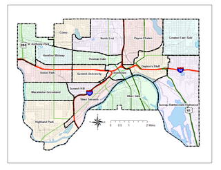
Saint Paul, Minnesota, consists of 17 officially defined city districts or neighborhoods.
Ledbetter/Eagle Ford is a neighborhood in West Dallas, Texas, United States.

Arlington Heights is a neighborhood in Fort Worth, Texas.
The Dallas–Fort Worth metroplex has 1.2 million African-Americans, the 2nd-largest metro population of African-Americans in Texas.


