Comorian independence referendum, 1974

Last updated
Coat of arms of Comoros.svg
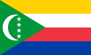
This article is part of a series on the
politics and government of
the Comoros

An independence referendum was held in the Comoros on 22 December 1974. The overall result was a strong "yes" vote, with 94.57% of voters voting for independence and almost all the "no" votes being cast in Mayotte, where there was a majority for remaining under French control. [1] In contrast, on Mohéli only five out of 6,059 votes were against independence. Voter turnout was 93.3%. [2]

Comoros sovereign archipelago island nation in the Indian Ocean

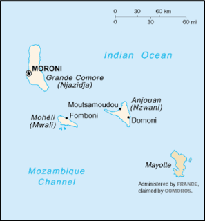
The Comoros, officially the Union of the Comoros, is an island country in the Indian Ocean located at the northern end of the Mozambique Channel off the eastern coast of Africa between northeastern Mozambique, the French region of Mayotte, and northwestern Madagascar. The capital and largest city in Comoros is Moroni. The religion of the majority of the population is Sunni Islam.

Mayotte Overseas region and department in France

Mayotte is an overseas department and region of France officially named the Department of Mayotte. It consists of a main island, Grande-Terre, a smaller island, Petite-Terre, and several islets around these two. The archipelago is located in the northern Mozambique Channel in the Indian Ocean off the coast of Southeast Africa, between northwestern Madagascar and northeastern Mozambique. The department status of Mayotte is recent and the region remains, by a significant margin, the poorest in France. Mayotte is nevertheless much more prosperous than the other countries of the Mozambique Channel, making it a major destination for illegal immigration.

France Republic with mainland in Europe and numerous oversea territories

France, officially the French Republic, is a country whose territory consists of metropolitan France in Western Europe and several overseas regions and territories. The metropolitan area of France extends from the Mediterranean Sea to the English Channel and the North Sea, and from the Rhine to the Atlantic Ocean. It is bordered by Belgium, Luxembourg and Germany to the northeast, Switzerland and Italy to the east, and Andorra and Spain to the south. The overseas territories include French Guiana in South America and several islands in the Atlantic, Pacific and Indian oceans. The country's 18 integral regions span a combined area of 643,801 square kilometres (248,573 sq mi) and a total population of 67.3 million. France, a sovereign state, is a unitary semi-presidential republic with its capital in Paris, the country's largest city and main cultural and commercial centre. Other major urban areas include Lyon, Marseille, Toulouse, Bordeaux, Lille and Nice.

Contents

Following the referendum, the country declared independence on 6 July 1975, with Mayotte remaining under French control.

Background

The Comoros had achieved autonomy in 1961, and public satisfaction with the new arrangement meant that the islands had not been part of the decolonisation that saw most of France's African territories become independent in the 1960s. However, public support for independence began to grow in the early 1970s, except in Mayotte, where support for retaining French sovereignty remained strong. [3]

A treaty was signed on 15 January 1973, allowing for the islands to become independent within five years following a consultation with the residents. The French government approved the treaty on 2 October, opting for a single referendum for the whole colony rather than an island-by-island vote. The approach was criticised in Mayotte, where Marcel Henry, leader of the anti-independence Mahoré People's Movement, claimed Mayotte residents had a right to self-determination based on article 53 of the French Constitution, which states that secession cannot happen without the consent of voters. [3]

Marcel Henry is a politician from Mayotte and a former French senator (1977-2004). He is one of the founders of the Mahoré People's Movement.

The Mahoré People's Movement is a political party in the French overseas department of Mayotte, established in 1963. In the last elections for the General Council, on 21 and 28 March 2004, the party won 1.2% of the popular vote, and 1 out of 19 seats.

Constitution of France French Constitution adopted in 1958

The current Constitution of France was adopted on 4 October 1958. It is typically called the Constitution of the Fifth Republic, and replaced that of the Fourth Republic dating from 1946. Charles de Gaulle was the main driving force in introducing the new constitution and inaugurating the Fifth Republic, while the text was drafted by Michel Debré. Since then the constitution has been amended twenty-four times, most recently in 2008.

When the National Assembly approved the treaty in November 1973, it made an amendment that required Mayotte to be given regional autonomy if independence were to be achieved. In November 1974 law 74–965 was passed, requiring the holding of a referendum in the Comoros within six months, but also allowing a six-month period following the results to decide on its reaction to them. [3]

National Assembly (France) lower house of the French Parliament under the Fifth Republic

The National Assembly is the lower house of the bicameral Parliament of France under the Fifth Republic, the upper house being the Senate. The National Assembly's members are known as députés.

Results

« Souhaitez-vous que le territoire des Comores devienne indépendant ?»
Do you want the Comoros' territory to become independent?
IslandForAgainstInvalid
votes
Total
votes
Registered
voters
Voter
Turnout %
Votes%Votes%
Anjouan 58,89799.93440.07458,94561,40695.99
Grande Comore 84,12399.98210.023984,18389,21594.36
Mayotte 5,11036.788,78363.228413,97717,94677.88
Mohéli 6,05499.9250.0836,0626,35195.45
Total154,18494.578,8535.43130163,167174,91893.28
Source: African Elections Database

Aftermath

Following the referendum, President Ahmed Abdallah announced that the Comorian Chamber of Deputies would draw up a new constitution, and that independence would be declared in agreement with the French government. The result in Mayotte led the French government to try and convince their Comorian counterparts that a new constitution should allow the island autonomy from the rest of the country. However, Abdallah stated that he was against a federal state. [3] He rejected a draft constitution on 11 April 1975 on the basis that it allowed for too much decentralisation.

Ahmed Abdallah Abderemane was a Comorian politician. He was a member of the French Senate from 1959 to 1973, and President of the Comoros from 25 October 1978 until his death.

Assembly of the Union of the Comoros

The unicameral Assembly of the Union of the Comoros is the country's legislative body. It was established in 2004, and its predecessor was the Federal Assembly.

On 3 July 1975 the French National Assembly approved a new law on Comorian independence, with the second article stating that the new constitution should be approved individually by each island. If an island rejected the new constitution, a new one would have to be presented in three months. If any island rejected the second draft, they would not be subject to it. However, the Comorian government rejected the French law, with Abdallah's Oudzima party declaring that "The Comoros people disapprove of interference by the French Parliament in the internal affairs of the future Comoros state, condemn all manoeuvres to balkanise the Comoros, and consequently reject the provisions of the act of 30 June 1975."

On 6 July the Comorian Chamber of Deputies unilaterally declared independence of the entire Comoros archipelago. The French government recognised the independence of Grande Comore, Anjouan and Mohéli on 31 December 1975, but did not mention Mayotte. A referendum was subsequently held in Mayotte in February 1976 on remaining part of the Comoros, with the proposal rejected by over 99% of voters, the voter turnout was observed to be 83.34%, and the number of registered voters was increased to 21,671. [4]

Related Research Articles

The history of the Comoros goes back some 1,500 years. The Comoros have been inhabited by various groups throughout this time. France colonised the islands in the 19th century, and they became independent in 1975.

Geography of the Comoros

The Comoros archipelago consists of four main islands aligned along a northwest-southeast axis at the north end of the Mozambique Channel, between Mozambique and the island of Madagascar. Still widely known by their French names, the islands officially have been called by their Swahili names by the Comorian government. They are Grande Comore (Njazidja), Mohéli (Mwali), Anjouan (Nzwani), and Mayotte (Mahoré). The islands' distance from each other—Grande Comore is some 200 kilometers from Mayotte, forty kilometers from Mohéli, and eighty kilometers from Grande Comore—along with a lack of good harbor facilities, make transportation and communication difficult. Comoros has lots of sun.

Politics of the Comoros

Politics of the Union of the Comoros takes place in a framework of a federal presidential republic, whereby the President of the Comoros is both head of state and head of government, and of a multi-party system. Executive power is exercised by the government. Federal legislative power is vested in both the government and parliament.

Anjouan island

Anjouan is an autonomous high island in the Indian Ocean that forms part of the Union of the Comoros. Its chief town is Mutsamudu and, as of 2006, its population is around 277,500. The total area of the island is 424 square kilometers.

Flag of the Comoros flag

The national flag of the Union of the Comoros was designed in 2001 and officially adopted on January 7, 2002. It continues to display the crescent and four stars, which is a motif that has been in use in slightly various forms since 1975 during the independence movement. In its constitution, the government of the Comoros refers to the insignia as l'emblème national, or the "national emblem", though it is understood to actually represent a flag.

Comoro Islands archipelago in the Indian Ocean

The Comoro Islands or Comoros form an archipelago of volcanic islands situated off the south-east coast of Africa, to the east of Mozambique and north-west of Madagascar. The islet of Banc du Geyser and the Glorioso Islands are part of the archipelago. The islands are politically divided between Union of the Comoros and two territories of France : the region of Mayotte and the Glorioso Islands, a part of the Scattered Islands in the Indian Ocean, the 5th district of the French Southern and Antarctic Lands.

Mohéli island

Mohéli, also known as Mwali, is an autonomous island that forms part of the Union of the Comoros.

Grande Comore island

Grande Comore is an island in the Indian Ocean off the coast of Africa. It is the largest island in the Comoros nation. Most of its population is of the Comorian ethnic group. Its population as of 2006 is about 316,600. The island's capital is Moroni, which is also the national capital. The island is made up of two shield volcanoes, with Mount Karthala being the country's highest point at 2,361 m (7,746 ft) above sea level. According to the 2009 revision of the constitution of 2002, it is governed by an elected Governor, as are the other islands, with the federal government being much reduced in power. The name Ngazidja is sometimes seen in the now nonstandard form Njazidja.

Elections in the Comoros

Elections in the Comoros take place within the framework of a multi-party democracy and a presidential system. The President and the majority of the seats in the Assembly of the Union are directly elected.

2006 Comorian presidential election

Presidential elections were held in the Comoros on 16 April and 14 May 2006. As it was the turn of the island of Anjouan to hold the union presidency, a primary election was held in Anjouan on 16 April, prior to a national election on 14 May. The result was a victory for Ahmed Abdallah Mohamed Sambi, who received 58% of the vote in the national election.

The Comorian Union for Progress is a political party in the Comoros.

The postage stamps and postal history of the Comoro Islands is an overview of the postage stamps and postal history of the Comoro Islands, an Indian Ocean archipelago located on the south-east side of Africa.

Postage stamps and postal history of Mayotte

This is an overview of the postage stamps and postal history of the Indian Ocean island of Mayotte, one of the Comoros Archipelago islands located on the south-east side of Africa.

1987 Comorian legislative election

Parliamentary elections were held in the Comoros on 22 March 1987. The result was a victory for the Comorian Union for Progress, the sole legal party, which won all 42 seats in the first round of voting. Voter turnout was around 65%.

2001 Comorian constitutional referendum

A constitutional referendum was held in the Comoros on 23 December 2001. The proposed amendments to the constitution were approved by 77% of voters, with a turnout of 75.4%.

Ikililou Dhoinine Comoros president

Ikililou Dhoinine is a Comorian politician who was the President of the Comoros from 2011 to 2016; he was a Vice-President of Comoros from 2006 to 2011.

1997 Anjouan independence referendum

An independence referendum was held on Anjouan, an island in the Comoros, on 26 October 1997. Over 99% of voters voted in favour of independence. However, the vote was not recognised and the island returned to the control of the Comorian government in 2001.

2019 Comorian presidential election

Early presidential elections will be held in the Comoros on 24 March 2019 alongside regional elections. If required, a second round will be held on 21 April.

References

  1. Comoros detailed election results African Elections Database
  2. Elections in the Comoros African Elections Database
  3. 1 2 3 4 Pierre Cyril Pahlavi (2003) The Comoros: "The Federation of the Quarrelsome Sultans" Archived 2013-04-26 at the Wayback Machine . Gateway
  4. Mayotte, 8 February 1976: Remaining in the Comoros Direct Democracy (in German)