Related Research Articles
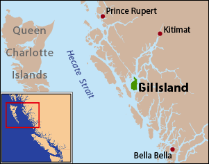
Gil Island is an island on the North Coast of British Columbia, Canada, located on the west side of Whale Channel in the entrance to Douglas Channel, one of the main coastal inlets, on the route of the Inside Passage between Pitt Island and Princess Royal Island. It is 26 km (16 mi) long, with a width ranging from 6 to 13 km, and an area of 231 km2. The only named summit on the mountainous island is Mount Gil, which faces the opening of Douglas Channel.

The Gwa'Sala-Nakwaxda'xw Nations are a union of two Kwakwaka'wakw peoples in a band government based on northern Vancouver Island in British Columbia, Canada, whose main reserve community is near the town of Port Hardy in the Queen Charlotte Strait region of the Central Coast region of British Columbia, Canada. The band government is a member of the Kwakiutl District Council and, for treaty negotiation purposes, the Winalagalis Treaty Group which includes three other members of the Kwakiutl District Council.

Porcher Island is an island in Hecate Strait, British Columbia, Canada, near the mouth of the Skeena River and southwest of the port city of Prince Rupert. The locality of Porcher Island is located near the island's northern tip at Humpback Bay, 54°05′11″N130°23′23″W. Stephens and Prescott Islands are located off its northwestern tip.
The Mamalilikulla Band is a First Nations band government based on northern Vancouver Island in British Columbia, Canada. The home territory of the Mamalilikulla and Qwe-Qwa'Sot'Em groups of Kwakwaka'wakw was in the maze of islands and inlets of the eastern Queen Charlotte Strait region around the opening of Knight Inlet, mainly on Village Island, where their principal village Memkumlis is.
New Vancouver, also known as Tzatsisnukomi, T˜sadzis' nukwame' or t̕sa̱dzis'nukwa̱me'' in the Kwak'wala language, is a Kwakwaka'wakw community on Harbledown Island in the Queen Charlotte Strait region of the Central Coast of British Columbia, near the community of Alert Bay. New Vancouver is the main village of the Da'naxda'xw subgroup of the Kwakwaka'wakw peoples. New Vancouver is at Dead Point on the north end of Harbeldown Island, at the west end of Beware Passage.
Actaeon Sound is a sound in the Queen Charlotte Strait region of the Central Coast of British Columbia, branching off northeasterly from the north side of Drury Inlet near its head on the mainland of British Columbia to the north of the town of Port McNeill, on the opposite side of Queen Charlotte Strait. On the south side of the sound is the Bond Peninsula at 50°56′50″N127°06′55″W, which is formed by a sidewater, Bond Lagoon at 50°56′34″N127°06′34″W, both presumably named in 1865 by Captain Pender, in association with other Admiralty and HMS Actaeon-related names.
The Tlowitsis Nation, formerly the Klowitsis Tribe, the Turnour Island Band and the Tlowitsis-Mumtagila First Nation, is the Indian Act band government of the Ławit'sis (Tlowitsis) tribe of the Kwakwaka'wakw peoples, located in the Queen Charlotte Strait-Johnstone Strait area in the Discovery Islands between Vancouver Island and the British Columbia mainland in Canada. Ławit'sis territory covers parts of northern Vancouver Island, Johnstone Strait, and adjoining inlets of the mainland. Kalugwis, on Turnour Island, was their principal community in times past, but the band's offices are in the city of Campbell River to the southeast. Hanatsa IR No. 6 on Port Neville is the most populated of the band's Indian reserves.
Tribune Channel is a channel or strait on the Central Coast of British Columbia, Canada, separating Gilford Island on the west and north from the mainland. The channel bends around Gilford Island, with the mouth of Thompson Sound at the elbow of the bend, opening eastwards to the mouth of the Kakweiken River.
The Deserters Group is a small group of islands in the Queen Charlotte Strait region of the Central Coast of British Columbia, Canada, off the northeast coast of Vancouver Island to the north of Port Hardy. Deserters Island and Wishart Island are among it.
Hanson Island is an island in the Queen Charlotte Strait region of the Central Coast of British Columbia, located west of Harbledown Island and south of the Plumper Islands. The westernmost part of Johnstone Strait is to the south of the island, Blackfish Sound to the north, beyond which is Swanson Island. The island is named for James Hanson who served aboard HMS Chatham in 1792 and was later transferred that year to command Vancouver's supply ship HMS Daedalus.
Harbledown Island is an island in the Central Coast region of British Columbia, Canada, located west of West Cracroft Island. It is at the west end of Johnstone Strait and lies at the eastern edge of the Queen Charlotte Strait region. Hanson Island is to its west, West Cracroft Island to the south and southeast, across Baronet Passage, and Turnour Island to the northwest, across Beware Passage.

Broughton Island is an island in the Broughton Archipelago of the Queen Charlotte Strait area of the Central Coast of British Columbia, northwest of Gilford Island.

East Cracroft Island is an island in the Johnstone Strait region of the Central Coast region of British Columbia, Canada. It is the smaller of the two Cracroft Islands, and at low tide is really one island with its larger neighbour, West Cracroft Island. On the south side of the shallows that form an isthmus between them at low tide is Port Harvey, a short, wide inlet or bay. On its east shore is Keecekiltum Indian Reserve No. 2, which is under the governance of the Tlowitsis Nation of the Kwakwaka'wakw peoples. at 50°33′00″N126°16′00″W.
Eliot Passage is a marine waterway between Village Island (E) and Pearl Island (W) in the Johnstone Strait region of the Central Coast of British Columbia, Canada, southwest of the opening of Knight Inlet. The Kwakwaka'wakw village of Memkumlis, also known as Mamalillaculla after the name of the group of Kwakwaka'wakw whose principal village it is, is on its eastern shore on Village Island.
Compton Island is an island in the Queen Charlotte Strait-Johnstone Strait region of the Central Coast of British Columbia, Canada, in Blackfish Sound to the east of Port McNeill All of it and three small adjacent islands comprise Compton Island Indian Reserve No. 6, a.k.a. Compton 6.
Wells Passage is a strait and marine waterway in the northeastern Queen Charlotte Strait region of the Central Coast of British Columbia, Canada, on the west side of North Broughton Island. Across from that island, the headland at the northwest entrance to the passage is Compton Point.
Watson Island is an island in the Queen Charlotte Strait region of the Central Coast of British Columbia, Canada, located to the north of North Broughton Island in the entrance to Mackenzie Sound. It is named for Alexander Watson colonial treasurer of Vancouver Island in 1866 and later an official with the original Bank of British Columbia.
Drury inlet is an inlet in the Queen Charlotte Strait region of the Central Coast of British Columbia, Canada, extending west from Wells Passage to the northwest of North Broughton Island, northwest of the town of Port Hardy. Branching off to the northeast from the north side of the head of the inlet is Actaeon Sound.
Bonwick Island is an island in the Broughton Archipelago in Central Coast region of the Canadian province of British Columbia. The archipelago is on the northeast side of Queen Charlotte Strait and lies northwest of the village of Alert Bay and immediately to the west of Gilford Island, separated from it by Retreat Pass. Arrow Passage is to its northwest, separating it from Mars Island.
Waddington Harbour is a harbour at the head of Bute Inlet in the Central Coast region of British Columbia, Canada. Also issuing into the head of Bute Inlet and Waddington Harbour, just east of the mouth of the Homathko, is the Teaquahan River. Issuing directly into the inlet a few miles south on the harbour's southeast is the Southgate River, one of the major rivers of the central Pacific Ranges, which begins on the west side of the Lillooet Icecap. Its lower valley adjacent to the inlet's shores is called Pigeon Valley.
References
- ↑ BC Names entry "Compton Point"
- ↑ Victoria Colonist, August 23, 1862
- ↑ British Columbia Coast Names, 1592-1906: their origin and history, John T. Walbran, Ottawa, 1909 (republished for the Vancouver Public Library by J.J. Douglas Ltd, Vancouver, 1971), quoted in the BC Names entry.
- ↑ BC Names/GeoBC entry "Compton Island"
- ↑ BC Names/GeoBC entry "Compton Point"
50°53′09″N126°53′45″W / 50.88583°N 126.89583°W
| | This article about a location on the Central Coast of British Columbia, Canada is a stub. You can help Wikipedia by expanding it. |