
Marche, in English sometimes referred to as the Marches, is one of the twenty regions of Italy. The region is located in the central area of the country, and has a population of about 1.5 million people, being the thirteenth largest region in the country by number of inhabitants. The region's capital and largest city is Ancona.

Romagna is an Italian historical region that approximately corresponds to the south-eastern portion of present-day Emilia-Romagna in northern Italy.

Fano is a town and comune of the province of Pesaro and Urbino in the Marche region of Italy. It is a beach resort 12 kilometres southeast of Pesaro, located where the Via Flaminia reaches the Adriatic Sea. It is the third city in the region by population after Ancona and Pesaro.

The province of Rimini is the southernmost province of the Emilia-Romagna region of Italy. Its capital is the city of Rimini, one of the "seven sisters" of the historical region of Romagna.

The province of Pesaro and Urbino is a province in the Marche region of Italy. Its capital is the city of Pesaro. It also borders the state of San Marino. The province is surrounded by San Marino and Emilia Romagna in the north, Umbria and Tuscany in the west, Ancona in the south and the Adriatic Sea on the east. The province has an enclave of the Umbrian commune of Citta' di Castello named Monte Ruperto. The province is also known as "Riviera of Hills". It is mostly covered by hills and is popular for its beaches.

The Metauro is a river in the Marche region of central Italy. It rises in the Apennine Mountains and runs east for 110 kilometres (68 mi) or 121 kilometres (75 mi) if the Meta is included as its uppermost reach.

The province of Fermo is a province in the Marche region of Italy. It was established in 2004 and became operational in 2009. Its administrative centre and provincial capital is the city of Fermo. Other major cities include Porto Sant'Elpidio, Porto San Giorgio, Sant'Elpidio a Mare, and Montegranaro. As of 2017, the province has a population of 174,358 inhabitants and spans an area of 862.77 square kilometres (333.12 sq mi). It contains 40 comuni.
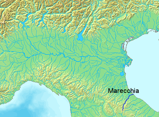
The Marecchia is a river in eastern Italy, flowing from near Monte dei Frati in the province of Arezzo, Tuscany, to the Adriatic Sea in Rimini, Emilia-Romagna. Along its course, the river passes next to or near the settlements of Novafeltria, Verucchio, and Santarcangelo di Romagna. It passes near the Republic of San Marino. Among its tributaries are the San Marino river and the Ausa.
Coriano is a comune in the province of Rimini. This town is known for being the town of the Motorcycle World Champion, in 250cc class, Marco Simoncelli.

Gabicce Mare, also named Gabicce, is a town and comune (municipality) in the province of Pesaro and Urbino, in Italy, region Marche. It is located about 70 kilometres (43 mi) northwest of Ancona, 16 kilometres (10 mi) north of Pesaro, and is close to the borders with the province of Rimini, in Emilia-Romagna.

Novafeltria, historically Mercatino Marecchia, is a comune in the province of Rimini, in the region of Emilia-Romagna, northern Italy.

Sassofeltrio is a comune (municipality) in the Province of Rimini in the Italian region Emilia-Romagna, located about 145 kilometres (90 mi) southeast of Bologna and about 21 kilometres (13 mi) south of Rimini.

Tavullia is a comune (municipality) in the Province of Pesaro and Urbino in the Marche region of Italy, located about 70 kilometres (43 mi) northwest of Ancona and about 15 kilometres (9 mi) southwest of Pesaro. Until 13 December 1938, it was known as Tomba di Pesaro.

The Cesano is a river in the Marche region of Italy. Its source is near Monte Catria on the border between the province of Perugia and the province of Pesaro e Urbino. The river flows northeast through Pesaro e Urbino before forming the border between Pesaro e Urbino and the province of Ancona for a short distance. It continues flowing northeast through Pesaro e Urbino and flows past Pergola before becoming the border with Ancona again near San Lorenzo in Campo. The river flows northeast near Mondavio, Corinaldo and Monte Porzio before the province of Ancona extends westward beyond the bank of the river for a short distance near Mondolfo. Finally, the river flows into the Adriatic Sea north of Senigallia and south of Marotta and Fano.

Montefeltro is a historical and geographical region in northern Italy. It gave its name to the Montefeltro family, who ruled in the area during the Middle Ages and the Renaissance.

The Foglia is the northernmost river of the Marche region of Italy. In ancient times it was known as Pisaurus, as it debouched into the Adriatic Sea at Pisaurum. It was also known as the Isaurus. The source of the river is west of Sestino in the province of Arezzo in the Umbrian-Marchean Apennines mountains. It flows east through an extension of the province of Pesaro e Urbino and then back into Arezzo before forming the border between Arezzo and Pesaro e Urbino. The river then flows into the province of Pesaro e Urbino past Piandimeleto and curves northeast and flows past Sassocorvaro before curving east again. The river meanders south of Montecalvo in Foglia before curving northeast and flowing near Colbordolo, Saludecio, Sant'Angelo in Lizzola, Montecchio, Montelabbate and Tavullia before entering the Adriatic Sea near Pesaro.
Biancame is a white Italian wine grape variety that is grown in the Marche and Emilia-Romagna regions of Italy. Here it is an important component in the Denominazione di origine controllata (DOC) wines of Bianchello del Metauro and Colli di Rimini.

The Candigliano is a river in the Marche and Umbria regions of Italy. Its source is in the Appennino Umbro-Marchigiano mountains in the province of Pesaro e Urbino near the border with the province of Perugia. The river flows east and forms the border between Pesaro e Urbino and Perugia for a short distance south of Mercatello sul Metauro before entering Pesaro e Urbino. It then continues flowing east past an exclave called Monte Ruperto belonging to Città di Castello and then past Piobbico, where it is joined by the Biscubio. The river is joined by the Burano at Acqualagna and flows northeast near the Furlo Pass until it joins the Metauro west of Fossombrone.
The Biscubio is a river in the Umbria and Marche regions of Italy. Its source is in the province of Perugia near the border with the province of Pesaro e Urbino in the Appennino Umbro-Marchigiano mountains. The river flows northeast into Pesaro e Urbino south of Mercatello sul Metauro. It then flows east through the mountains near Apecchio and the exclave called Monte Ruperto belonging to Città di Castello until it joins the Candigliano near Piobbico.

The Burano is a river in the Umbria and Marche regions of Italy. Its source is in the province of Perugia in the Appennino Umbro-Marchigiano mountains. The river crosses the border into the province of Pesaro e Urbino and flows north near Monte Catria, Cantiano, Monte Nerone, and Cagli before entering the Candigliano at Acqualagna.

