
The Metauro is a river in the Marche region of central Italy. It rises in the Apennine Mountains and runs east for 110 kilometres (68 mi) or 121 kilometres (75 mi) if the Meta is included as its uppermost reach.
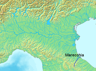
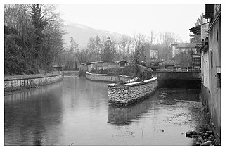
The Marecchia is a river in eastern Italy. In ancient times it was known as the Ariminus which was from the Greek Aríminos. The source of the river is near Monte dei Frati which is east of Pieve Santo Stefano and southwest of Badia Tedalda in the province of Arezzo in Tuscany. It flows northeast into the province of Pesaro and Urbino in the Marche and is the only river that runs through Montefeltro. While flowing through Montefeltro, the river flows through the exclave Santa Sofia Marecchia, which belongs to Badia Tedalda. The river then flows past Sant'Agata Feltria and Novafeltria before crossing into the province of Rimini in Emilia–Romagna. At Torello, part of the commune of San Leo, it flows 1 km west of the Sammarinese territory Acquaviva and the San Marino River flows into it, but the Marecchia does not touch the San Marino border. Finally, the river flows past Verucchio and Santarcangelo di Romagna before flowing into the Adriatic Sea near Rimini.

The Aterno-Pescara is a river system in Abruzzo, eastern central Italy. The river is known as the Aterno near its source in the mountains, but takes the name Pescara, actually a tributary, nearer the city of Pescara and the Adriatic Sea.

The Agri is a river in the Basilicata region of southern Italy. In ancient times it was known as Aciris. The source of the river is in the Lucan Apennines north of Monte Volturino and west of Calvello in the province of Potenza. It is near the source of the Basento. The river flows south near Paterno before curving southeast. It flows near Tramutola, Viggiano, and Grumento Nova before entering a lake. After exiting the lake, the river flows eastward near Armento, Missanello, Aliano, and Sant'Arcangelo. A right tributary, the Racanello, enters the river in this area. The river forms the border between the province of Potenza and the province of Matera for part of this area of the river. It flows into a small lake before entering the province of Matera. The river flows for a short distance before entering Lago di Gannano. After exiting the lake, the river flows southeast near Tursi, Montalbano Jonico, and Scanzano Jonico before flowing into the Gulf of Taranto near Policoro.

Nicholas Geoffrey Lemprière Hammond, was a British scholar of ancient Greece and an operative for the British Special Operations Executive (SOE) in occupied Greece during the Second World War.
Hammond Map or Hammond World Atlas Corporation is an American map company. It was formerly an operating subsidiary of the Langenscheidt Publishing Group, a major map publisher in the United States, but was sold to Universal Map, an affiliate of Kappa Publishing Group, in 2010. Langenscheidt retained the rights to Hammond Publishing products.
Mount Bosavi is a mountain in the Southern Highlands province, Papua New Guinea. It is the collapsed cone of an extinct volcano on the Great Papuan Plateau, part of the Kikori River basin. The crater is approximately 4 km wide and 1 km deep; it is home to a number of endemic species.

The Montone is a river in the historical region of Romagna, which is in the present-day region of Emilia-Romagna in northern Italy. It is the northernmost river on the east-facing slopes of the Apennines to flow directly into the Adriatic Sea rather than entering the Po. Its Latin name was Utis or Vitis.

The Cesano is a river in the Marche region of Italy. Its source is near Monte Catria on the border between the province of Perugia and the province of Pesaro e Urbino. The river flows northeast through Pesaro e Urbino before forming the border between Pesaro e Urbino and the province of Ancona for a short distance. It continues flowing northeast through Pesaro e Urbino and flows past Pergola before becoming the border with Ancona again near San Lorenzo in Campo. The river flows northeast near Mondavio, Corinaldo and Monte Porzio before the province of Ancona extends westward beyond the bank of the river for a short distance near Mondolfo. Finally, the river flows into the Adriatic Sea north of Senigallia and south of Marotta and Fano.

The Tronto is a 115-kilometre (71 mi) long Italian river that arises at Monti della Laga and ends in the Adriatic Sea at Porto d'Ascoli, San Benedetto del Tronto. It traverses the Lazio, Marche, and Abruzzo regions of Italy.
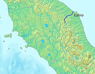
The Esino is a river in the Marche region of central Italy.

Monte Gorzano is the highest peak in the Monti della Laga, in northern Abruzzo, central Italy. It has an elevation of 2,458 metres (8,064 ft) and is also the highest peak of Lazio. It is located on the boundary with the provinces of Teramo in the Abruzzo region and Rieti in the Lazio region. The source of the Tordino is near Monte Gorzano (Fiumata).

The Conca is a river in the Marche and Emilia-Romagna regions of Italy. Its source is Monte Carpegna, which is in the Montefeltro part of the province of Pesaro e Urbino. The river flows northeast near Macerata Feltria and Mercatino Conca before crossing into the province of Rimini. The river then flows past Morciano di Romagna before entering the Adriatic Sea southeast of Misano Adriatico and northwest of Cattolica.
The Misa is a river in the Marche region of Italy. It runs for over 48 kilometres through the region. The source of the river lies south of Arcevia in the province of Ancona. The river flows northeast near Serra de' Conti, Ostra Vetere and Ostra. The river is joined by the Nevola before entering the Adriatic Sea near Senigallia.
The Livenza is a river in the Italian provinces of Pordenone, Treviso and Venice. Its source is near Polcenigo and Caneva in Pordenone. It flows in a southeasterly direction past Sacile and forms the border between the provinces of Pordenone and Treviso roughly between Brugnera and Motta di Livenza. It continues to flow in a southeasterly direction, forming the border between the provinces of Treviso and Venice before flowing into the province of Venice near Santo Stino di Livenza. It flow near La Salute di Livenza and finally enters the Adriatic Sea near Caorle.

The Potenza is a river in the province of Macerata in the Marche region of Italy. The source of the river is in the territory of Fiuminata. The source is located at an elevation of 800 metres (2,600 ft) on Monte Pennino. The river flows northeast through the communes of Pioraco, Castelraimondo, San Severino Marche, Macerata, Montelupone, Recanati and Potenza Picena. The river flows into the Adriatic Sea at Porto Recanati, after a course of some 95 kilometres (59 mi).

The Idice is a river in the Tuscany and Emilia-Romagna regions of Italy. The source of the river is in the province of Florence near Monghidoro in the Appennino Tosco-Emiliano mountains. The river flows north into the province of Bologna near Monterenzio before being joined by the Savena east of Bologna. The river then curves eastward and flows near Castenaso and Budrio before flowing into the province of Ferrara. It then flows into the Reno near where the Sillaro enters the Reno southeast of Argenta.
The Savena is a river in the Tuscany and Emilia-Romagna regions of Italy. The source of the river is in the province of Florence west of Firenzuola in the Appennino Tosco-Emiliano mountains. The river flows north into the province of Bologna and flows near Monghidoro, Loiano, Pianoro and San Lazzaro di Savena before curving east and flowing into the Idice east of Bologna.

Botte Donato is a mountain in the Calabria region of southern Italy. It is part of the La Sila mountainous plateau and is the highest peak in the range at 1,928 meters in height. The mountain is within Sila National Park and the province of Cosenza. To the north of the mountain are the lakes Lago di Cecita and Lago di Ariamacina and to the south is the lake Lago Arvo.

