
U.S. Route 7 (US 7) is a north–south United States Numbered Highway in western New England that runs for 308 miles (496 km) through the states of Connecticut, Massachusetts, and Vermont. The highway's southern terminus is at Interstate 95 (I-95) exit 15 in Norwalk, Connecticut. Its northern terminus is at I-89 exit 22 near the village of Highgate Springs, Vermont, immediately south of the Canada–United States border.

New York State Route 55 (NY 55) is a 122.45-mile-long (197.06 km) east-west state highway in southern New York, running from the Pennsylvania state line at the Delaware River in Barryville to the Connecticut state line at Wingdale. It is the only other state highway beside NY 7 to completely cross the state, from border to border, in an east–west direction, although NY 17 does so and is partially east–west. It also forms a concurrency when it joins US 44 for 33 miles (53 km).

New York State Route 376 (NY 376) is a state highway located entirely within Dutchess County in the Hudson Valley region of New York in the United States. The route begins at an intersection with NY 52 in East Fishkill and passes north through Hopewell Junction and Red Oaks Mill on its way to the city of Poughkeepsie. It ends at a junction with U.S. Route 44 (US 44) and NY 55 east of the city limits in Arlington, a hamlet in the town of Poughkeepsie. NY 376 was originally designated as part of NY 39 in the mid-1920s. In the 1930 renumbering of state highways in New York, the East Fishkill–Poughkeepsie portion of NY 39 was renumbered to New York State Route 202. NY 202 was renumbered to NY 376 in 1935 to avoid numerical duplication with the new US 202.

New York State Route 343 (NY 343) is a state highway located entirely within central Dutchess County, in the Hudson Valley region of the U.S. state of New York. It runs east–west from the intersection of NY 82 in the village of Millbrook to the town of Amenia, where it crosses the Connecticut state line and continues eastward as Route 343, a Connecticut state highway located entirely within the town of Sharon. Along the way, it has a 7.3-mile (11.7 km) concurrency with NY 22 from vicinity of the hamlet of Dover Plains to the hamlet of Amenia.
New York State Route 292 (NY 292) is a short 7.58-mile-long (12.20 km) state highway in the Hudson Valley of New York in the United States, bridging Putnam and Dutchess counties. The southern terminus of the route is at an intersection with NY 311 in the town of Patterson, and the northern terminus is at a junction with NY 55 in the town of Pawling. NY 292 traverses mostly rural areas as it heads northwestward through Patterson and Pawling. Along the way, NY 292 passes along the southern and western edges of Whaley Lake.
New York State Route 75 (NY 75) is a north–south state highway in Erie County, New York, in the United States. It extends for 20.85 miles (33.55 km) from an intersection with NY 39 in the Collins hamlet of Collins Center to an interchange with NY 5 in the town of Hamburg. The route passes through the village of Hamburg, which serves as the northern terminus of a 2-mile (3.2 km) overlap between U.S. Route 62 (US 62) and NY 75. Past Hamburg, NY 75 connects to the New York State Thruway northwest of the village before ending a short distance from Lake Erie. The portion of NY 75 south of Hamburg is a two-lane rural highway; in contrast, the section north of the village is four lanes wide and serves commercial and residential areas.

New York State Route 341 (NY 341) was an east–west state highway located in Dutchess County, New York, in the United States. It extended for 4.71 miles (7.58 km) from an intersection with NY 22 and NY 55 in the village of Pawling to the Connecticut state line in the town of Pawling. At the state line, NY 341 continued eastward into Sherman, Connecticut, as a town road named Wakeman Road. The route crossed a largely undeveloped section of the county, utilizing parts of Quaker Hill Road, Mizzentop Road, and Kirby Hill Road.
Route 41 is a 17.86-mile (28.74 km) scenic state highway in rural Northwestern Connecticut. It extends from the New York state line in Sharon to the Massachusetts state line in Salisbury and is the only state-numbered route in Connecticut that has both its ends at a state border.

New York State Route 116 (NY 116) is an east–west state highway in Westchester County, New York, in the United States. It extends for 8.12 miles (13.07 km) from an intersection with U.S. Route 202 (US 202) in the town of Somers to the Connecticut state line, where it becomes that state's Route 116. As it heads east, NY 116 connects to Interstate 684 (I-684) and has an overlap with NY 121. NY 116 originally extended as far west as Peekskill when it was assigned as part of the 1930 renumbering of state highways in New York. It was cut back to its current length in the late 1930s.

New York State Route 430 (NY 430) is a state highway located entirely within Chautauqua County, New York, in the United States. Its western terminus is located at the Pennsylvania state line near the hamlet of Findley Lake in the town of Mina. The eastern terminus is located in the city of Jamestown at a junction with NY 60 and NY 394. NY 430 is ceremoniously designated as the Senator Jess J. Present Memorial Highway in honor of Jess Present, a New York State Senator from Jamestown.

New York State Route 346 (NY 346) and Vermont Route 346 (VT 346) are short, adjoining state highways in the northeastern United States. Together, they extend for a combined 7.25 miles (11.67 km) through the towns of Petersburgh in Rensselaer County, New York, and Pownal in Bennington County, Vermont. The bi-state highway begins at an intersection with NY 22 in the hamlet of North Petersburgh and heads generally southeastward across the New York–Vermont state line to a junction with U.S. Route 7 (US 7) in the village of Pownal. Both NY 346 and VT 346 parallel the Hoosick River.
New York State Route 41A (NY 41A) is a north–south state highway in Central New York in the United States. It extends for 25.49 miles (41.02 km) from an intersection with NY 41 in the Cortland County town of Homer to a junction with U.S. Route 20 (US 20) in the Onondaga County village of Skaneateles. The southern half of NY 41A serves mostly rural areas, while the route's northern half runs along the western edge of Skaneateles Lake. NY 41A was assigned as part of the 1930 renumbering of state highways in New York to several previously unnumbered state roads and a section of pre-1930 NY 26.
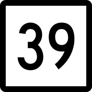
Route 39 is a north–south state highway in Connecticut. It is one of the main roads in downtown Danbury. Route 39 runs 22.76 miles (36.63 km) from Interstate 84 (I-84) in Danbury north to Route 55 in Sherman.

Route 121 is a state highway in southern Connecticut running from U.S. Route 1 in Milford to Route 34 near the Orange-Derby line.

Route 37 is a north–south state highway in Connecticut running 18.66 miles (30.03 km) from Interstate 84 (I-84) in Danbury north to U.S. Route 7 in New Milford. The northernmost section between the town centers of Sherman and New Milford was once part of an early toll road known as the New Milford and Sherman Turnpike chartered in 1818.

Route 45 is a Connecticut state highway from US 202 in Washington to US 7 in Cornwall, in the rural northwest of the state. It is 10.29 miles (16.56 km) long and runs north–south.

Route 116 is a 4.24-mile-long (6.82 km) state highway entirely within Ridgefield, Connecticut that runs from the Ridgefield town center at Route 35 to the New York state line, where New York State Route 116 continues towards the hamlet of North Salem.
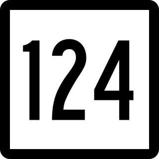
Route 124 is a state highway in southwestern Connecticut running from downtown Darien through the center of New Canaan to the state line in Scotts Corners, New York.

U.S. Route 7 (US 7) is a north–south United States Numbered Highway which runs 78 miles (126 km) in the state of Connecticut. The route begins at Interstate 95 (I-95) in Norwalk starting out as a four-lane freeway until the Wilton town line. The route then proceeds north as a two-lane surface road through Redding and Ridgefield, where it becomes a four-lane surface road until it reaches Danbury. The route becomes a four-lane freeway again, eventually merging with I-84 for a brief period before it turns and proceeds north with US 202 in Brookfield. The freeway section terminates at an intersection with US 202 at the Fairfield–Litchfield county line next to Candlewood lake. The route then continues north as a four-lane arterial road to New Milford, where it becomes a two-lane surface road, running north to the Massachusetts border in North Canaan. US 7 was aligned to its current route around 1930, and, since then, three sections totaling around 12 miles (19 km) have been upgraded to freeway standards.
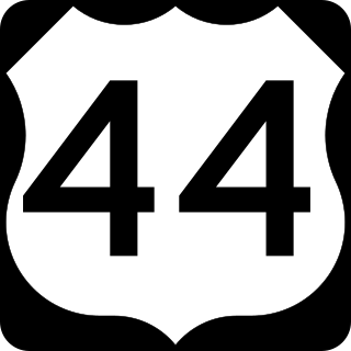
U.S. Route 44 (US 44) is an east–west United States Numbered Highway that runs for 237 miles (381 km) through four states in the Northeastern United States. The western terminus is at US 209 and New York State Route 55 (NY 55) in Kerhonkson, New York, a hamlet in the Hudson Valley region. The eastern terminus is at Route 3A in Plymouth, Massachusetts.


