
Dutchess County is a county in the U.S. state of New York. As of the 2020 census, the population was 295,911. The county seat is the city of Poughkeepsie. The county was created in 1683, one of New York's first twelve counties, and later organized in 1713. It is located in the Mid-Hudson Region of the Hudson Valley, north of New York City.

Dover is a town in Dutchess County, New York, United States. The population was 8,415 at the 2020 census. The town was named after Dover in England, the home town of an early settler.
Dover Plains is a hamlet and census-designated place (CDP) in Dutchess County, New York, United States. The population was 1,323 at the 2010 census. It is part of the Poughkeepsie–Newburgh–Middletown Metropolitan Statistical Area.

Fairview is a hamlet and census-designated place (CDP) in Dutchess County, New York, United States. The population was 5,515 at the 2010 census. It is part of the Poughkeepsie–Newburgh–Middletown, NY Metropolitan Statistical Area as well as the larger New York–Newark–Bridgeport, NY-NJ-CT-PA Combined Statistical Area.

Hopewell Junction is a hamlet and census-designated place (CDP) in Dutchess County, New York, United States. The population was 1330 at the 2020 census. It is part of the Poughkeepsie–Newburgh–Middletown, NY Metropolitan Statistical Area as well as the larger New York–Newark–Bridgeport, NY-NJ-CT-PA Combined Statistical Area.

Amenia is a hamlet and census-designated place (CDP) in Dutchess County, New York, United States. The population was 955 at the 2010 census. It is part of the Poughkeepsie–Newburgh–Middletown, NY Metropolitan Statistical Area as well as the larger New York–Newark–Bridgeport, NY-NJ-CT-PA Combined Statistical Area.
Amenia is a town in Dutchess County, New York, United States. The population was 3,769 at the 2020 census, down from 4,436 at the 2010 census. The town is on the eastern border of the county.

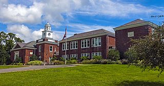
Pawling is a town in Dutchess County, New York, United States. Its population was 8,012 at the 2020 census. The town is named after Catherine Pauling, the daughter of Henry Beekman, who held the second largest land patent in the county. A misprint caused the U to change to a W and the name stuck. The town is in the southeastern part of the county, and contains a village of the same name.

Pine Plains is a hamlet and census-designated place (CDP) in Dutchess County, New York, United States. The population was 1,142 at the 2020 census. It is part of the Poughkeepsie–Newburgh–Middletown, NY Metropolitan Statistical Area as well as the larger New York–Newark–Bridgeport, NY-NJ-CT-PA Combined Statistical Area.
Central Bridge is a hamlet and census-designated place (CDP) within the towns of Schoharie and Esperance in Schoharie County, New York, United States. As of the 2010 census, the population was 593.
Harlem Valley State Hospital, south of the hamlet of Wingdale in the town of Dover, was a New York State psychiatric hospital that operated from 1924 to 1994.
Bliss is the largest hamlet and a census-designated place (CDP) in the town of Eagle, Wyoming County, New York, United States. As of the 2010 census, it had a population of 527.

Freedom Plains is a hamlet and census-designated place (CDP) in Dutchess County, New York, United States. As of the 2010 census the population was 421.
Wilmington is the primary village and a census-designated place (CDP) in the town of Wilmington, Windham County, Vermont, United States. As of the 2020 census, it had a population of 439, compared to 2,255 in the entire town. The center of the village is part of the Wilmington Village Historic District.
Wilmington is a hamlet and census-designated place (CDP) in the town of Wilmington in Essex County, New York, United States. The population of the CDP was 937 at the 2010 census, out of a total town population of 1,253.
Chelsea is the primary village and a census-designated place (CDP) in the town of Chelsea, Orange County, Vermont, United States. It was first listed as a CDP prior to the 2020 census.
York is a hamlet and census-designated place (CDP) in the town of York, Livingston County, New York, United States. Its population was 544 as of the 2010 census. New York State Route 36 passes through the community.

U.S. Route 44 (US 44) is an east–west United States Numbered Highway that runs for 237 miles (381 km) through four states in the Northeastern United States. The western terminus is at US 209 and New York State Route 55 (NY 55) in Kerhonkson, New York, a hamlet in the Hudson Valley region. The eastern terminus is at Route 3A in Plymouth, Massachusetts.
South Ilion is a hamlet and census-designated place (CDP) in the town of German Flatts in Herkimer County, New York, United States. It was first listed as a CDP prior to the 2020 census.
Grafton is the central village and a census-designated place (CDP) in the town of Grafton, Windham County, Vermont, United States. As of the 2020 census, it had a population of 49, compared to 645 in the entire town.


