
Mining is the extraction of valuable geological materials from the Earth and other astronomical objects. Mining is required to obtain most materials that cannot be grown through agricultural processes, or feasibly created artificially in a laboratory or factory. Ores recovered by mining include metals, coal, oil shale, gemstones, limestone, chalk, dimension stone, rock salt, potash, gravel, and clay. The ore must be a rock or mineral that contains valuable constituent, can be extracted or mined and sold for profit. Mining in a wider sense includes extraction of any non-renewable resource such as petroleum, natural gas, or even water.

Beekman is a town in Dutchess County, New York, United States. It is part of the Poughkeepsie–Newburgh–Middletown, NY Metropolitan Statistical Area as well as the larger New York–Newark–Bridgeport, NY-NJ-CT-PA Combined Statistical Area. The population was 14,172 at the 2020 census. The town was named after Henry Beekman, a 17th-century land owner.

Fort Montgomery is a hamlet in Orange County, New York, United States. The population was 1,627 at the 2020 census. It is part of the Poughkeepsie–Newburgh–Middletown, NY Metropolitan Statistical Area as well as the larger New York–Newark–Bridgeport, NY-NJ-CT-PA Combined Statistical Area.

Mineral Ridge is an unincorporated community and census-designated place in southern Trumbull and northern Mahoning counties in the U.S. state of Ohio. The population was 3,951 at the 2020 census. It is a suburb of the Youngstown–Warren metropolitan area. Mineral Ridge was named for valuable coal deposits near the original town site.

The Sauerland is a rural, hilly area spreading across most of the south-eastern part of North Rhine-Westphalia, in parts heavily forested and, apart from the major valleys, sparsely inhabited.
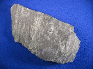
Taconite is a variety of banded iron formation, an iron-bearing sedimentary rock, in which the iron minerals are interlayered with quartz, chert, or carbonate. The name "taconyte" was coined by Horace Vaughn Winchell (1865–1923) – son of Newton Horace Winchell, the Minnesota State Geologist – during their pioneering investigations of the Precambrian Biwabik Iron Formation of northeastern Minnesota. He believed the sedimentary rock sequence hosting the iron-formation was correlative with the Taconic orogeny of New England, and referred to the unfamiliar and as-yet-unnamed iron-bearing rock as the 'taconic rock' or taconyte.

The Iron Range is collectively or individually a number of elongated iron-ore mining districts around Lake Superior in the United States and Canada. Much of the ore-bearing region lies alongside the range of granite hills formed by the Giants Range batholith. These cherty iron ore deposits are Precambrian in the Vermilion Range and middle Precambrian in the Mesabi and Cuyuna ranges, all in Minnesota. The Gogebic Range in Wisconsin and the Marquette Iron Range and Menominee Range in Michigan have similar characteristics and are of similar age. Natural ores and concentrates were produced from 1848 until the mid-1950s, when taconites and jaspers were concentrated and pelletized, and started to become the major source of iron production.

Benxi is a prefecture-level city located in the east of Liaoning province, People's Republic of China, south-southeast of the provincial capital Shenyang. As of the 2020 census, its population was 1,326,018 whom 809,655 lived in the built-up area made of 3 urban districts. It was founded as a metallurgical center in 1915. Benxi Iron and Steel Company (Bengang) is the largest employer in the city, and used to be the fourth-largest steel company in China. The second-largest industry in Benxi is coal mining. The city has pollution problems due to steel production and coal mining.

The Eyre Peninsula is a triangular peninsula in South Australia. It is bounded by the Spencer Gulf on the east, the Great Australian Bight on the west, and the Gawler Ranges to the north.

The Never Summer Mountains are a mountain range in the Rocky Mountains in north central Colorado in the United States consisting of seventeen named peaks. The range is located along the northwest border of Rocky Mountain National Park, forming the continental divide between the headwaters of the Colorado River in Rocky Mountain National Park to the local-east and the upper basin of the North Platte River to the local-west; the continental divide makes a loop in these mountains. The range is small and tall, covering only 25 sq mi (65 km2) with a north–south length of 10 mi (16 km) while rising to over 12,000 ft (3,700 m) at over ten distinct peaks. The range straddles the Jackson-Grand county line for most of its length, and stretches into Jackson and Larimer county at its northern end. A panoramic view of the range is available from sections of Trail Ridge Road in Rocky Mountain National Park. One of the northernmost peaks, Nokhu Crags, is prominently visible from the west side of Cameron Pass.

Parys Mountain is located south of the town of Amlwch in north east Anglesey, Wales. It is the site of a large copper mine that was extensively exploited in the late 18th century. Parys Mountain is a mountain in name only, being a hill with an elevation of less than 150m.

Captains Flat is a town in the Southern Tablelands of rural New South Wales, Australia, in Queanbeyan-Palerang Regional Council. It is south of Queanbeyan. Captains Flat township is bounded by the non-urban parts of the locality of Captains Flat in the north, east and west, and Captains Flat Road, the Molonglo River and Foxlow Street in the south.

Kryvbas, full name Kryvyi Rih Iron Ore Basin (Ukrainian: Криворізький залізорудний басейн, romanized: Kryvorizkyi zalizorudnyi besein, Russian: Криворожский железорудный бассейн is an important economic and historical region stretched between central and southern Ukraine around the city of Kryvyi Rih, specializing in iron ore mining, steel industry and some uranium ore mining in the past 20th century. It is arguably the main iron ore region of Eastern Europe.
The Gogebic Range is an elongated area of iron ore deposits located within a range of hills in northern Michigan and Wisconsin just south of Lake Superior. It extends from Lake Namakagon in Wisconsin eastward to Lake Gogebic in Michigan, or almost 80 miles. Though long, it is only about a half mile wide and forms a crescent concave to the southeast. The Gogebic Range includes the communities of Ironwood in Michigan, plus Mellen and Hurley in Wisconsin.
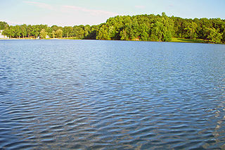
Sylvan Lake is located next to the community by that name in the Town of Beekman, New York, United States. It is the deepest and second-largest lake in Dutchess County.
The Seine River Diversion is a river diversion in Rainy River District in northwestern Ontario, Canada located near Atikokan. It was built to divert water around open-pit hematite iron ore mining at Steep Rock Lake beginning in 1943.
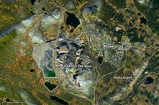
The Kiruna mine is the largest and most modern underground iron ore mine in the world. The mine is located in Kiruna in Norrbotten County, Lapland, Sweden. The mine is owned by Luossavaara-Kiirunavaara AB (LKAB), a large Swedish mining company. In 2018 the mine produced 26.9 million tonnes of iron ore. The Kiruna mine has an ore body which is 4 km (2.5 mi) long, 80 metres (260 ft) to 120 metres (390 ft) thick and reaching a depth of up to 2 km (1.2 mi). Since mining began at the site in 1898, the mine has produced over 950 million tonnes of ore. As of 2020 the main haulage level is 1365 m below the ore outcrop at Kiirunavaara that existed prior to mining.
St. Denis Church is a Roman Catholic parish church under the authority of the Roman Catholic Archdiocese of New York, located in Hopewell Junction, Dutchess County, New York. It was established in 1899 as a parish; it was established a mission of St. Mary in Wappingers Falls in 1874 until being elevated in a parish in 1899.

Elcor is a ghost town, or more properly, an extinct town, in the U.S. state of Minnesota that was inhabited between 1897 and 1956. It was built on the Mesabi Iron Range near the city of Gilbert in St. Louis County. Elcor was its own unincorporated community before it was abandoned and was never a neighborhood proper of the city of Gilbert. Not rating a figure in the national census, the people of Elcor were only generally considered to be citizens of Gilbert. The area where Elcor was located was annexed by Gilbert when its existing city boundaries were expanded after 1969.
