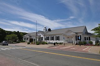
New Fairfield is a town in Fairfield County, Connecticut, United States. The population was 13,579 at the 2020 census. New Fairfield is one of five towns that surround Candlewood Lake, the largest lake in Connecticut. The town is located 55 miles (89 km) northeast of New York City, making it part of the New York metropolitan area. The town is part of the Western Connecticut Planning Region.

U.S. Route 7 (US 7) is a north–south United States Numbered Highway in western New England that runs for 308 miles (496 km) through the states of Connecticut, Massachusetts, and Vermont. The highway's southern terminus is at Interstate 95 (I-95) exit 15 in Norwalk, Connecticut. Its northern terminus is at I-89 exit 22 near the village of Highgate Springs, Vermont, immediately south of the Canada–United States border.

Route 58 is a primary state highway in the U.S. state of Connecticut connecting the towns of Fairfield and Bethel. Route 58 is 18.58 miles (29.90 km) long and is one of the primary routes to the downtown Danbury area via Routes 302 and 53.

Route 53 is a state highway in the U.S. state of Connecticut, connecting the cities of Norwalk and Danbury. Most of the route has been made redundant by U.S. Route 7, except for the last section from Bethel to Danbury, which is part of a direct route from the Bridgeport area to Danbury.

Route 55 is a state highway in the western part of the U.S. state of Connecticut, running from the New York state line in Sherman to New Milford. It functions as an extension of New York State Route 55 to US 7.
Route 35 is a state highway in Connecticut, located entirely within the town of Ridgefield, Fairfield County. Route 35 starts at the New York state line, where the road continues as New York State Route 35, and ends at U.S. Route 7. The road is often used as an alternative to the congested Route 7. Originally part of New England Route 3 in the 1920s, Route 35 was designated in 1932.
New York State Route 292 (NY 292) is a short 7.58-mile-long (12.20 km) state highway in the Hudson Valley of New York in the United States, bridging Putnam and Dutchess counties. The southern terminus of the route is at an intersection with NY 311 in the town of Patterson, and the northern terminus is at a junction with NY 55 in the town of Pawling. NY 292 traverses mostly rural areas as it heads northwestward through Patterson and Pawling. Along the way, NY 292 passes along the southern and western edges of Whaley Lake.

New York State Route 341 (NY 341) was an east–west state highway located in Dutchess County, New York, in the United States. It extended for 4.71 miles (7.58 km) from an intersection with NY 22 and NY 55 in the village of Pawling to the Connecticut state line in the town of Pawling. At the state line, NY 341 continued eastward into Sherman, Connecticut, as a town road named Wakeman Road. The route crossed a largely undeveloped section of the county, utilizing parts of Quaker Hill Road, Mizzentop Road, and Kirby Hill Road.
Route 64 is a Connecticut state highway connecting the towns of Woodbury and Waterbury via Middlebury.

Route 37 is a north–south state highway in Connecticut running for 18.66 miles (30.03 km) from I-84, Route 39 and Route 53 in Danbury, through New Fairfield, to U.S. Route 7 in New Milford. The northernmost section between the town centers of Sherman and New Milford was once part of an early toll road known as the New Milford and Sherman Turnpike chartered in 1818.

Route 116 is a 4.24-mile-long (6.82 km) state highway entirely within Ridgefield, Connecticut that runs from the Ridgefield town center at Route 35 to the New York state line, where New York State Route 116 continues towards the hamlet of North Salem.
Route 123 is a secondary state highway in southwestern Connecticut from Norwalk to the New York state line near the town of Lewisboro.

Route 102 is a state highway in southwestern Connecticut running from the center of Ridgefield to the Branchville section of the same town.

Route 104 is a Connecticut state highway in the city of Stamford, starting from the Bulls Head section of the city then through North Stamford, with the highway ending at New York state line.

Route 107 is a state highway in southwestern Connecticut, connecting the village of Georgetown to the town center of Redding.
Route 124 is a state highway in southwestern Connecticut running from downtown Darien through the center of New Canaan to the state line in Scotts Corners, New York.

Route 136 is a state highway in southwestern Connecticut, running from Darien to Easton. The route was initially established in 1932 to serve the beach communities between Darien and Southport. Its eastern end was relocated in 1963 to head northeast from Westport to Easton instead.

Route 195 is a state highway in northeastern Connecticut, running from the Willimantic section of Windham to the town center of Tolland via Storrs and Mansfield Center. The road is the main thoroughfare to access the main campus of the University of Connecticut.

Route 302 is a state highway in western Connecticut running from Bethel to Newtown.

U.S. Route 7 (US 7) is a north–south United States Numbered Highway which runs 78 miles (126 km) in the state of Connecticut. The route begins at Interstate 95 (I-95) in Norwalk starting out as a four-lane freeway until the Wilton town line. The route then proceeds north as a two-lane surface road through Redding and Ridgefield, where it becomes a four-lane surface road until it reaches Danbury. The route becomes a four-lane freeway again, eventually merging with I-84 for a brief period before it turns and proceeds north with US 202 in Brookfield. The freeway section terminates at an intersection with US 202 at the Fairfield–Litchfield county line next to Candlewood lake. The route then continues north as a four-lane arterial road to New Milford, where it becomes a two-lane surface road, running north to the Massachusetts border in North Canaan. US 7 was aligned to its current route around 1930, and, since then, three sections totaling around 12 miles (19 km) have been upgraded to freeway standards.


