Related Research Articles

In aviation, instrument flight rules (IFR) is one of two sets of regulations governing all aspects of civil aviation aircraft operations; the other is visual flight rules (VFR).
In aviation, visual flight rules (VFR) are a set of regulations under which a pilot operates an aircraft in weather conditions generally clear enough to allow the pilot to see where the aircraft is going. Specifically, the weather must be better than basic VFR weather minima, i.e., in visual meteorological conditions (VMC), as specified in the rules of the relevant aviation authority. The pilot must be able to operate the aircraft with visual reference to the ground, and by visually avoiding obstructions and other aircraft.
The basic principles of air navigation are identical to general navigation, which includes the process of planning, recording, and controlling the movement of a craft from one place to another.
Airspace is the portion of the atmosphere controlled by a country above its territory, including its territorial waters or, more generally, any specific three-dimensional portion of the atmosphere. It is not the same as outer space which is the expanse or space outside the Earth and aerospace which is the general term for Earth's atmosphere and the outer space within the planet's vicinity.

In aviation, visual meteorological conditions (VMC) is an aviation flight category in which visual flight rules (VFR) flight is permitted—that is, conditions in which pilots have sufficient visibility to fly the aircraft maintaining visual separation from terrain and other aircraft. They are the opposite of instrument meteorological conditions (IMC). The boundary criteria between IMC and VMC are known as the VMC minima and are defined by: visibility, cloud ceilings, and cloud clearances.
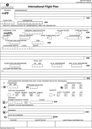
Flight plans are documents filed by a pilot or flight dispatcher with the local Air Navigation Service Provider prior to departure which indicate the plane's planned route or flight path. Flight plan format is specified in ICAO Doc 4444. They generally include basic information such as departure and arrival points, estimated time en route, alternate airports in case of bad weather, type of flight, the pilot's information, number of people on board, and information about the aircraft itself. In most countries, flight plans are required for flights under IFR, but may be optional for flying VFR unless crossing international borders. Flight plans are highly recommended, especially when flying over inhospitable areas such as water, as they provide a way of alerting rescuers if the flight is overdue. In the United States and Canada, when an aircraft is crossing the Air Defense Identification Zone (ADIZ), either an IFR or a special type of VFR flight plan called a DVFR flight plan must be filed. For IFR flights, flight plans are used by air traffic control to initiate tracking and routing services. For VFR flights, their only purpose is to provide needed information should search and rescue operations be required, or for use by air traffic control when flying in a "Special Flight Rules Area."
In general aviation, scud running is a practice in which pilots lower their altitude to avoid clouds or instrument meteorological conditions (IMC). The goal of scud running is to stay clear of weather to continue flying with visual, rather than instrument, references. This practice is widely accepted to be dangerous, and has led to death in many cases from pilots flying into terrain or obstacles, such as masts and towers, normally referred to as controlled flight into terrain, or CFIT; however, even instrument-rated pilots sometimes elect to take the risk to avoid icing or embedded thunderstorms in cloud, or in situations where the minimum instrument altitudes are too high for their aircraft.
The world's navigable airspace is divided into three-dimensional segments, each of which is assigned to a specific class. Most nations adhere to the classification specified by the International Civil Aviation Organization (ICAO) and described below, though they might use only some of the classes defined below, and significantly alter the exact rules and requirements. Similarly, individual nations may also designate special use airspace (SUA) with further rules for reasons of national security or safety.
An instrument rating is an authorization required for a pilot to fly under instrument flight rules (IFR). In the United States, the rating is issued by the Federal Aviation Administration.

In aviation, an instrument approach or instrument approach procedure (IAP) is a series of predetermined maneuvers for the orderly transfer of an aircraft operating under instrument flight rules from the beginning of the initial approach to a landing, or to a point from which a landing may be made visually. These approaches are approved in the European Union by EASA and the respective country authorities and in the United States by the FAA or the United States Department of Defense for the military. The ICAO defines an instrument approach as "a series of predetermined maneuvers by reference to flight instruments with specific protection from obstacles from the initial approach fix, or where applicable, from the beginning of a defined arrival route to a point from which a landing can be completed and thereafter, if landing is not completed, to a position at which holding or en route obstacle clearance criteria apply."
Special visual flight rules are a set of aviation regulations under which a pilot may operate an aircraft. It is a special case of operating under visual flight rules (VFR).

Allegheny Airlines Flight 853 was a regularly scheduled Allegheny Airlines flight from Boston, Massachusetts, to St. Louis, Missouri, with stops in Baltimore, Maryland, Cincinnati, Ohio, and Indianapolis, Indiana. On September 9, 1969, the aircraft serving the flight, a McDonnell Douglas DC-9, collided in mid-air with a Piper PA-28 light aircraft near Fairland, Indiana. The DC-9 was carrying 78 passengers and 4 crew members, and the Piper was leased to a student pilot on a solo cross-country flight. All 83 occupants of both aircraft were killed in the accident and both aircraft were destroyed.
VFR over-the-top (OTT) refers to flying over top of clouds in visual flight, rather than with reference to instruments. This is usually done for brief amount of time to avoid weather or turbulence.
In aviation, a standard terminal arrival route (STAR) is a published flight procedure followed by aircraft on an instrument flight rules (IFR) flight plan just before reaching a destination airport.

Special use airspace (SUA) is a type of special airspaces in the United States designated for operations of a nature such that limitations may be imposed on aircraft not participating in those operations. Often these operations are of a military nature. The designation of SUAs identifies for other users the areas where such activity occurs, provides for segregation of that activity from other users, and allows charting to keep airspace users informed of potential hazards.
An aeronautical chart is a map designed to assist in the navigation of aircraft, much as nautical charts do for watercraft, or a roadmap does for drivers. Using these charts and other tools, pilots are able to determine their position, safe altitude, best route to a destination, navigation aids along the way, alternative landing areas in case of an in-flight emergency, and other useful information such as radio frequencies and airspace boundaries. There are charts for all land masses on Earth, and long-distance charts for trans-oceanic travel.
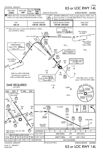
Approach plates are the printed or digital charts of instrument approach procedures that pilots use to fly instrument approaches during instrument flight rules (IFR) operations. Each country maintains its own instrument approach procedures according to International Civil Aviation Organization (ICAO) standards.

The United States airspace system's classification scheme is intended to maximize pilot flexibility within acceptable levels of risk appropriate to the type of operation and traffic density within that class of airspace – in particular to provide separation and active control in areas of dense or high-speed flight operations.

In aviation, a visual approach is an approach to a runway at an airport conducted under instrument flight rules (IFR) but where the pilot proceeds by visual reference and clear of clouds to the airport. The pilot must at all times have either the airport or the preceding aircraft in sight. This approach must be authorized and under the control of the appropriate air traffic control (ATC) facility. The International Civil Aviation Organization (ICAO) definition adds that the visual approach can commence when "either part or all of an instrument approach is not completed", varying only slightly from the Federal Aviation Administration regulation and is essentially identical.

The 1971 Colorado Aviation Aero Commander 680 crash claimed the life of decorated American World War II veteran Audie Murphy and five other people on May 28, 1971. The aircraft's passengers were on a business trip from Atlanta, Georgia, to Martinsville, Virginia, aboard an Aero Commander 680 Super twin-engined aircraft owned and operated by Colorado Aviation Co, Inc. The aircraft crashed into the side of Brush Mountain, 14 nautical miles northwest of Roanoke, Virginia, during conditions of poor visibility.
References
- 1 2 3 "Contact Approach" (PDF). Pilot/Controller Glossary (P/CG). Federal Aviation Administration. 2019-08-15. Retrieved 2019-09-27.
- 1 2 3 4 5 Thomas, Horne (1988-08-01). "Instrument Insights Part 8 of 12: Tricks of the Trade". AOPA Pilot Magazine. 41 (8). Archived from the original on 2010-05-21. Retrieved 2010-11-26.
- 1 2 3 4 Federal Aviation Administration, ed. (2019-08-15). "Contact Approach". Aeronautical Information Manual. Washington, D.C.: U.S. Department of Transportation. pp. 5–4–24. Retrieved 2019-09-27.