Related Research Articles

Lincoln is a town in Grafton County, New Hampshire, United States. It is the second-largest town by area in New Hampshire. The population was 1,631 at the 2020 census. The town is home to the New Hampshire Highland Games and to a portion of Franconia Notch State Park. Set in the White Mountains, large portions of the town are within the White Mountain National Forest. The Appalachian Trail crosses the western and northeastern parts of the town. Lincoln is the location of Loon Mountain Ski Resort and associated recreation-centered development.

New Hampshire is a state in the New England region of the Northeastern United States. It borders Massachusetts to the south, Vermont to the west, Maine and the Gulf of Maine to the east, and the Canadian province of Quebec to the north. Of the 50 U.S. states, New Hampshire is the seventh-smallest by land area and the tenth-least populous, with a population of 1,377,529 residents as of the 2020 census. Concord is the state capital and Manchester is the most populous city. New Hampshire's motto, "Live Free or Die", reflects its role in the American Revolutionary War; its nickname, "The Granite State", refers to its extensive granite formations and quarries. It is well known nationwide for holding the first primary in the U.S. presidential election cycle, and for its resulting influence on American electoral politics.

Franconia is a town in Grafton County, New Hampshire, United States. The population was 1,083 at the 2020 census. Set in the White Mountains, Franconia is home to the northern half of Franconia Notch State Park. Parts of the White Mountain National Forest are in the eastern and southern portions of the town. The Appalachian Trail crosses the town.

The White Mountains are a mountain range covering about a quarter of the state of New Hampshire and a small portion of western Maine in the United States. They are a subrange of the northern Appalachian Mountains and the most rugged mountains in New England. Several of the higher peaks contain an Alpine tundra. The range is heavily visited due to its proximity to Boston, New York City, and Montreal.
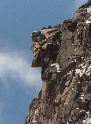
The Old Man of the Mountain, also called the Great Stone Face and the Profile, was a series of five granite cliff ledges on Cannon Mountain in Franconia, New Hampshire, United States, that appeared to be the jagged profile of a human face when viewed from the north. The rock formation, 1,200 feet (370 m) above Profile Lake, was 40 feet (12 m) tall and 25 feet (7.6 m) wide.

The White Mountains Region is a tourism region designated by the New Hampshire Division of Travel and Tourism. It is located in northern New Hampshire in the United States and is named for the White Mountains, which cover most of the region. The southern boundary of the region begins at Piermont on the west, and runs east to Campton, then on to Conway and the Maine border. The northern boundary begins at Littleton and runs east to Gorham and the Maine border. The region to the north is known as the Great North Woods Region, which should not be confused with the larger and more general Great North Woods.
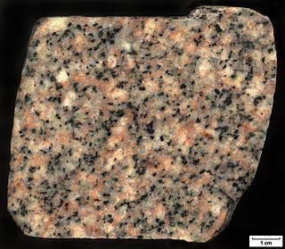
Quartz monzonite is an intrusive, felsic, igneous rock that has an approximately equal proportion of orthoclase and plagioclase feldspars. It is typically a light colored phaneritic (coarse-grained) to porphyritic granitic rock. The plagioclase is typically intermediate to sodic in composition, andesine to oligoclase. Quartz is present in significant amounts. Biotite and/or hornblende constitute the dark minerals. Because of its coloring, it is often confused with granite, but whereas granite contains more than 20% quartz, quartz monzonite is only 5–20% quartz. Rock with less than five percent quartz is classified as monzonite. A rock with more alkali feldspar is a syenite whereas one with more plagioclase is a quartz diorite. The fine grained volcanic rock equivalent of quartz monzonite is quartz latite.

Franconia Notch State Park is a public recreation area and nature preserve that straddles eight miles (13 km) of Interstate 93 as it passes through Franconia Notch, a mountain pass between the Kinsman Range and Franconia Range in the White Mountains of northern New Hampshire, United States. The northern part of the park, including Cannon Mountain and Echo and Profile lakes, is in the town of Franconia, and the southern part, including Lonesome Lake and the Flume, is in Lincoln. Attractions in the state park include the Flume Gorge and visitor center, the Old Man of the Mountain historical site, fishing in Echo Lake and Profile Lake, and miles of hiking, biking and ski trails.

Franconia Notch is a major mountain pass through the White Mountains of New Hampshire. Dominated by Cannon Mountain to the west and Mount Lafayette to the east, it lies principally within Franconia Notch State Park and is traversed by the Franconia Notch Parkway. The parkway required a special act of Congress to sidestep design standards for the Interstate highway system because it is only one lane in each direction.

Mount Lafayette is a 5,249-foot (1,600 m) mountain at the northern end of the Franconia Range in the White Mountains of New Hampshire, United States. It lies in the town of Franconia in Grafton County, and appears on the New England Fifty Finest list of the most topographically prominent peaks in New England. The mountain's upper reaches are located in the alpine zone, an area where only dwarf vegetation exists due to the harsh climate.
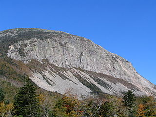
Cannon Mountain is a 4,080-foot (1,240 m) peak in the White Mountains of New Hampshire. It is known for both its technical rock and ice climbing on its cliff face and skiing at Cannon Mountain Ski Area. It was also home to the Old Man of the Mountain, until that formation collapsed on May 3, 2003.

Mount Moosilauke is a 4,802-foot-high (1,464 m) mountain at the southwestern end of the White Mountains in the town of Benton, New Hampshire, United States. It is the tenth highest and most southwesterly of the 4,000 foot summits in the White Mountains.

White Mountain art is the body of work created during the 19th century by over four hundred artists who painted landscape scenes of the White Mountains of New Hampshire in order to promote the region and, consequently, sell their works of art.

Kinsman Notch is a mountain pass located in the White Mountains of New Hampshire, United States. It is the westernmost of the major notches through the White Mountains. To the southeast, the valley of the notch is drained by the Lost River, leading to the Pemigewasset River, and ultimately the Merrimack, flowing into the Gulf of Maine. The northwest half of the notch is drained by Beaver Brook and the Wild Ammonoosuc River, part of the Connecticut River watershed leading to Long Island Sound.

Profile Lake is a 13-acre (53,000 m2) water body located in Franconia Notch in the White Mountains of New Hampshire, at the foot of Cannon Mountain. The lake was given its name due to its location directly beneath the Old Man of the Mountain, a famous rock formation which collapsed in 2003. The lake is near the height of land in Franconia Notch; the lake's outlet is the Pemigewasset River, which flows south to the Merrimack River and ultimately the Gulf of Maine at Newburyport, Massachusetts.

Kinsman Mountain is a mountain located in Grafton County, New Hampshire. It is named after Nathan Kinsman, an early resident of Easton, New Hampshire, and is part of the Kinsman Range of the White Mountains. To the northeast, Kinsman is connected by The Cannon Balls ridge to Cannon Mountain.

The Pemigewasset Wilderness is a 45,000-acre (182 km2) federally designated Wilderness Area in the heart of New Hampshire's White Mountains. It is a part of the White Mountain National Forest. It is New Hampshire's largest wilderness area.
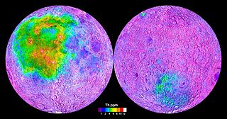
Thorium is found in small amounts in most rocks and soils. Soil commonly contains an average of around 6 parts per million (ppm) of thorium. Thorium occurs in several minerals including thorite (ThSiO4), thorianite (ThO2 + UO2) and monazite. Thorianite is a rare mineral and may contain up to about 12% thorium oxide. Monazite contains 2.5% thorium, allanite has 0.1 to 2% thorium and zircon can have up to 0.4% thorium. Thorium-containing minerals occur on all continents. Thorium is several times more abundant in Earth's crust than all isotopes of uranium combined and thorium-232 is several hundred times more abundant than uranium-235.

The geology of New Hampshire is similar to that of the rest of New England in comprising a series of metamorphosed sedimentary and volcanic rocks of Late Proterozoic to Devonian age, intruded by many plutons and dikes ranging in age from Late Proterozoic to early Cretaceous. New Hampshire is known as "the Granite State", but less than half is underlain by granite; much of it is schist or gneiss, both of which are metamorphic rocks.

Mount Pemigewasset, or Indian Head, is a mountain in Franconia Notch in the White Mountains in Grafton County, New Hampshire, United States. It lies near the town of Lincoln.
References
- 1 2 "Conway Granite." Mineral Resources On-Line Spatial Data. U.S. Geological Survey. U.S. Department of the Interior. No date. Accessed 2011-03-30.
- ↑ Adams, JA; Kline, MC; Richardson, KA; Rogers, JJ (1962). "The Conway Granite of New Hampshire as a Major Low-Grade Thorium Resource". Proc. Natl. Acad. Sci. U.S.A. 48 (11): 1898–905. Bibcode:1962PNAS...48.1898A. doi: 10.1073/pnas.48.11.1898 . PMC 221093 . PMID 16591014.
- ↑ Billings, Marland P. and Williams, Charles R. Geology of the Franconia Quadrangle, New Hampshire. Concord, N.H.: State Planning and Development Commission, 1935. p. 17.
- ↑ Hutchinson, Robert; Johnson, William; and Hamilton, Dick. The Old Man of the Mountain. San Francisco: Browntrout Publishers, 2003. p. 8.
- ↑ "New Hampshire geologic map data". U.S. Geological Survey. Retrieved January 5, 2015.
| | This article related to petrology is a stub. You can help Wikipedia by expanding it. |