Corn Exchange, Melton Mowbray

Last updated

Corn Exchange, Melton Mowbray
The Corn Exchange, Melton Mowbray (geograph 2360695).jpg
Corn Exchange, Melton Mowbray
LocationNottingham Street, Melton Mowbray
Coordinates 52°45′55″N0°53′15″W / 52.7654°N 0.8875°W / 52.7654; -0.8875
Built1855
ArchitectT. Mallinson and Son
Architectural style(s) Italianate style
Listed Building – Grade II
Official nameThe Former Corn Exchange
Designated12 October 1976
Reference no.1264925
Leicestershire UK location map.svg
Red pog.svg
Shown in Leicestershire

The Corn Exchange is a commercial building in Nottingham Street in Melton Mowbray, Leicestershire, England. The structure, which is now used to provide access to a shopping centre, is a Grade II listed building. [1]

Contents

History

In the mid-19th century, a group of local businessmen decided to form a private company, known as the "Melton Mowbray Corn Exchange and Public Rooms Company", to finance and commission a purpose-built corn exchange for the town. The site they selected was on the east side of Nottingham Street. [2]

The foundation stone for the new building was laid on 11 November 1854. [2] It was designed by T. Mallinson and Son of Nottingham in the Italianate style, built by John Norman and Son of Leicester in red brick with ashlar stone dressings and was completed in January 1855. [3] [4] [5] The design involved a symmetrical main frontage of three bays facing onto Nottingham Street. The ground floor featured three round headed openings with rusticated surrounds and voussoirs while the first floor was fenestrated by three round headed sash windows with window sills, architraves and cornices supported by brackets. There were quoins at the corners and, at roof level, there was a frieze, carved with the year "A. D. 1854", a cornice, which was supported by paired brackets, and, in the central bay, a small parapet carved with the words "Corn Exchange" surmounted by an octagon-shaped turret. [1] Internally, the principal room was the main hall which was 80 feet (24 m) long and 40 feet (12 m) wide. [2]

The use of the building as a corn exchange declined significantly in the wake of the Great Depression of British Agriculture in the late 19th century. [6] The building instead served as the venue for petty session hearings [3] and as the local office of the Midland District of the YMCA. [7] The 3rd Company of the 1st Administrative Battalion, Leicestershire Rifle Volunteer Corps, which had been raised in the town in 1860, evolved to become "C Company" of the 1st Volunteer Battalion, the Leicestershire Regiment in 1883 and trained at the corn exchange. [8]

The building was also used for public events: in 1911, the campaigners for women's suffrage, Millicent Fawcett and Daisy Renton, gave a talk in the building. [9] Other visitors included the Prince of Wales who attended the Royal British Legion Ball in the building, in March 1925. [10] The Prince of Wales returned, with the Duke of York and Prince Henry to attend a dinner there, organised by the local branch of the National Farmers' Union, in February 1926. [11] At the start of the Second World War, the building was used as a processing centre for evacuees transferred from London. [12] After the officers and men of the 4th Parachute Brigade, elements of which were based nearby at Staveley Lodge, took part in Operation Market Garden, they were entertained in the building in October 1944. [11] [13]

In the 1960s, the building became a popular concert venue: performers included Chris Farlowe, who performed with the band, The Thunderbirds, in 1967, [14] and Romeo Challenger, who performed with the band, Hal C. Blake, in 1969. [15] By the 1980s, the main hall had been demolished and the surviving part of the building, at the front, had become the entrance to a small shopping arcade known as The Bell Centre, named to commemorate The Bell Hotel, of which only the façade remains, to the south of the corn exchange. [16] [17] [18]

See also

Related Research Articles

<span class="mw-page-title-main">Leicestershire</span> County of England

Leicestershire is a ceremonial county in the East Midlands of England. It is bordered by Derbyshire, Nottinghamshire, and Lincolnshire to the north, Rutland to the east, Northamptonshire to the south-east, Warwickshire to the south-west, and Staffordshire to the west. The city of Leicester is the largest settlement and the county town.

<span class="mw-page-title-main">Melton Mowbray</span> Town in Leicestershire, England

Melton Mowbray is a town in the Melton district in Leicestershire, England, 19 miles (31 km) north-east of Leicester, and 20 miles (32 km) south-east of Nottingham. It lies on the River Eye, known below Melton as the Wreake. The town had a population of 27,670 in 2019. The town is sometimes promoted as Britain's "Rural Capital of Food"; it is the home of the Melton Mowbray pork pie and is the location of one of six licensed makers of Stilton cheese.

<span class="mw-page-title-main">Oakham</span> English East Midland town

Oakham is the county town of Rutland in the East Midlands of England, 25 miles (40.2 km) east of Leicester, 28 miles (45.1 km) south-east of Nottingham and 23 miles (37.0 km) north west of Peterborough. It had a population of 12,149 in the 2021 census. Oakham is to the west of Rutland Water and in the Vale of Catmose. Its height above sea level ranges from 325 to 400 ft.

<span class="mw-page-title-main">Borough of Melton</span> Borough and non-metropolitan district in England

Melton is a local government district with borough status in north-eastern Leicestershire, England. It is named after its only town, Melton Mowbray. The borough also includes numerous villages and surrounding rural areas. The north of the district includes part of the Vale of Belvoir. Melton is the least populous district of its type and the fourth least populous district in England overall.

<span class="mw-page-title-main">Bottesford, Leicestershire</span> Village in North Leicestershire, England

Bottesford is a village and civil parish in the Borough of Melton in the ceremonial county of Leicestershire, England. It lies close to the borders of Nottinghamshire and Lincolnshire.

<span class="mw-page-title-main">Langham, Rutland</span> Human settlement in England

Langham is a village and civil parish in Rutland in the East Midlands of England. The village is about 2 miles (3 km) north-west of Oakham, on the A606 main road linking Oakham and Melton Mowbray.

<span class="mw-page-title-main">Burrough on the Hill</span> Human settlement in England

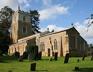
Burrough-on-the Hill is a small village and former civil parish, now in the parish of Somerby, in the Melton district, in the county of Leicestershire, England. It is 12 miles (19 km) north east of Leicester. The parish church is St. Mary the Virgin. Burrough Hill is an Iron Age hill fort near the village and is in an 86-acre (35 ha) country park of the same name. The hillfort stands on a promontory around 660 feet (200 m) above sea level, 7 miles (11 km) south of the modern settlement of Melton Mowbray. In 1931 the parish had a population of 214.

<span class="mw-page-title-main">Loughborough Town Hall</span> Municipal building in Loughborough, Leicestershire, England

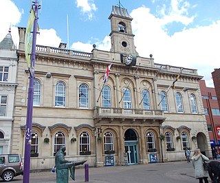
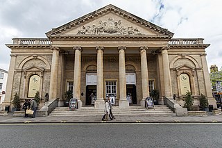
The Loughborough Town Hall is a building fronting onto the Market Place in Loughborough, Leicestershire, England. Built as a corn exchange and ballroom in 1855, it later became a municipal building and subsequently a theatre. It is a Grade II listed building. The building is still used for full council meetings of Charnwood Borough Council.

<span class="mw-page-title-main">A606 road</span> Road in East Midlands

The A606 is an A road in England that starts in West Bridgford, on the outskirts of Nottingham, and heads southeastwards through Leicestershire and the towns of Melton Mowbray and Oakham, terminating at Stamford, Lincolnshire on the former Great North Road.

<span class="mw-page-title-main">River Eye, Leicestershire</span> River in north-eastern Leicestershire, England

The River Eye is a slender, slow-flowing river in north-eastern Leicestershire, England. The river is known to flood periodically; especially within the town Melton Mowbray. Fine sediments from agricultural fields, the biggest known cause for the floods, have been recognized as a major source to the channel's supply. The river meanders throughout north-east Leicestershire where is it primarily flanked by farmland, and only crosses a handful of villages/towns. The primary wooded area it crosses is the fox covert. The farming in the district is largely made up of pasturing sheep and cows. Stilton and Red Leicester cheeses originally came from the villages and dairy farms in the Eye basin.

<span class="mw-page-title-main">Knipton</span> Human settlement in England

Knipton is a village and former civil parish, now in the parish of Belvoir, in the Melton district, in the county of Leicestershire, England. It lies about 6 miles (10 km) from the town of Grantham, just off the A607, and 10 miles (16 km) from Melton Mowbray. It borders the Duke of Rutland's estate at Belvoir Castle. Although the village is in Leicestershire, it has a Nottinghamshire postcode and a Lincolnshire (Grantham) STD code. In 1931 the parish had a population of 273. On 1 April 1936 the parish was abolished and merged with Belvoir.

<span class="mw-page-title-main">Thorpe Arnold</span> Village in Leicestershire, England

Thorpe Arnold is a farming village and former civil parish, now in the parish of Waltham on the Wolds and Thorpe Arnold in the district of Melton, which is approximately 1.2 miles (1.9 km) northeast of Melton Mowbray in Leicestershire, England. In 1931 the parish had a population of 128. On 1 April 1936 the parish was abolished and to form Waltham.

<span class="mw-page-title-main">Leicester Corn Exchange</span> Municipal building in Leicester, England

Leicester Corn Exchange is a commercial building in the Market Place in Leicester, Leicestershire, England. The structure, which currently operates as a public house, is a grade II* listed building.

<span class="mw-page-title-main">Grimston railway station</span> Former railway station in Leicestershire, England

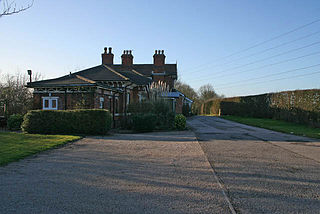
Grimston was a railway station serving Saxelbye village in the English county of Leicestershire. It was opened on the Nottingham direct line of the Midland Railway between London and Nottingham via Corby.The station was formerly named Saxelbye, the name was changed after only 3 months to avoid confusion with Saxby, a few miles east of Melton Mowbray, on the Midland's other line between Leicester and Peterborough. The village of Grimston lies about one mile to the north west of the former Grimston station. The line still exists today as the Old Dalby Test Track.

<span class="mw-page-title-main">Old Dalby railway station</span> Former railway station in Leicestershire, England

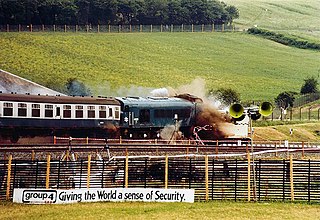
Old Dalby railway station served Old Dalby in the English county of Leicestershire. It was opened on the Nottingham direct line of the Midland Railway between London and Nottingham, avoiding Leicester. The line still exists today as the Old Dalby Test Track.

<span class="mw-page-title-main">Upper Broughton railway station</span> Former railway station in Nottinghamshire, England

Upper Broughton was a railway station serving Upper Broughton in the English county of Nottinghamshire. It was opened on the Nottingham direct line of the Midland Railway between London and Nottingham, avoiding Leicester. The line still exists today as the Old Dalby Test Track.

<span class="mw-page-title-main">Plumtree railway station</span> Former railway station in Nottinghamshire, England

Plumtree railway station served Plumtree in the English county of Nottinghamshire, on the Nottingham direct line of the Midland Railway between London and Nottingham, avoiding Leicester. The station is now closed, although the line still exists today as the Old Dalby Test Track.

<span class="mw-page-title-main">Rutland</span> County of England

Rutland, archaically Rutlandshire, is a ceremonial county and unitary authority in the East Midlands of England. It borders Leicestershire to the north and west, Lincolnshire to the north-east, and Northamptonshire to the south-west. Oakham is the largest town.

Edwalton railway station served the village and district of Edwalton in the English county of Nottinghamshire. It was opened on the Midland Railway Melton direct route between London and Nottingham, avoiding Leicester.

<span class="mw-page-title-main">Corn exchanges in England</span> Commodity trading halls in England

Corn exchanges are distinct buildings which were originally created as a venue for corn merchants to meet and arrange pricing with farmers for the sale of wheat, barley, and other corn crops. The word "corn" in British English denotes all cereal grains, such as wheat and barley. With the repeal of the Corn Laws in 1846, a large number of corn exchanges were built in England, particularly in the corn-growing areas of Eastern England.

References

  1. 1 2 Historic England. "The Former Corn Exchange (1264925)". National Heritage List for England . Retrieved 29 July 2023.
  2. 1 2 3 "Provincial News". The Builder. 18 November 1854. p. 594. Retrieved 29 July 2023.
  3. 1 2 White, William (1863). History, gazetteer, and directory of Leicestershire, and Rutland; together with the adjacent towns of Grantham & Stamford. p. 358.
  4. "Mallinson, Thomas". Dictionary of Irish Architects. Retrieved 29 July 2023.
  5. Pevsner, Nikolaus (1960). "Leicestershire and Rutland (Buildings of England Series)". p. 192.
  6. Fletcher, T. W. (1973). 'The Great Depression of English Agriculture 1873-1896' in British Agriculture 1875-1914. London: Methuen. p. 31. ISBN   978-1136581182.
  7. YMCA Year Book and Official Rosters. Young Men's Christian Associations. 1886. p. 165.
  8. MacDonald, Alan (2008). "A Lack of Offensive Spirit?" The 46th (North Midland) Division at Gommecourt 1st July 1916. Iona Books. p. 11. ISBN   978-0955811906.
  9. "Woman's Suffrage The Common Cause of Humanity". Vol. 3. National Union of Women's Suffrage Societies. 1911. p. 18.
  10. "The Prince and a Blind Woman". The Advertiser (Adelaide, South Australia). 23 March 1925. Retrieved 29 July 2023.
  11. 1 2 "Memorial Plaque on the wall". History Fare. Retrieved 29 July 2023.
  12. "Evacuees Melton Corn Exchange". Image Leicestershire. Retrieved 29 July 2023.
  13. "Parachute Regiment Reunion at Melton Mowbray" . Retrieved 29 July 2023.
  14. Watts, Derek (2010). "Country Boy A Biography of Albert Lee". McFarland, Incorporated. p. 80. ISBN   978-0786482955.
  15. "Romeo Challenger". Showaddywaddy. Retrieved 29 July 2023.
  16. "The Corn Exchange". Visitor UK. Retrieved 29 July 2023.
  17. "Fabulous vintage views show Melton Mowbray street 120 and 50 years ago". Leicestershire Live. 11 March 2020. Retrieved 29 July 2023.
  18. "Melton Mowbray Conservation Area Appraisal" (PDF). Melton Borough Council. p. 7. Retrieved 29 July 2023.