Related Research Articles
The Trojan Range is a mountain range rising to 2,760 metres (9,055 ft), extending northward from Mount Francais along the east side of Iliad Glacier, Anvers Island, in the Palmer Archipelago of the British Antarctic Territory. It was surveyed by the Falkland Islands Dependencies Survey (FIDS) in 1955 and named by the UK Antarctic Place-Names Committee (UK-APC) for the Trojans, one of the opposing sides in the Trojan War in Homer's Iliad.

Leppard Glacier is a large valley glacier draining east between the Aristotle Mountains and Voden Heights, and flowing into Scar Inlet north of Ishmael Peak, on the east coast of Graham Land, Antarctica. The glacier was first seen from the air and photographed in part by Hubert Wilkins on December 20, 1928, and was surveyed by the Falkland Islands Dependencies Survey (FIDS) in 1955. It is now clear that, on the photographic evidence of his outward flight, Wilkins gave the name "Crane Channel" to this glacier, and that on his return flight he photographed what is now accepted as Crane Glacier, perhaps thinking that it was the same feature. Since Crane Glacier has been retained for the northern of these glaciers photographed by Wilkins, the UK Antarctic Place-Names Committee has named this feature for Norman A.G. Leppard, assistant surveyor with the FIDS, who surveyed this area in 1955.
Leonardo Glacier is a glacier flowing into Wilhelmina Bay between Sadler Point and Café Point, on the west coast of Graham Land, Antarctica. It was charted by the Belgian Antarctic Expedition under Gerlache, 1897–99, and was named by the UK Antarctic Place-Names Committee in 1960 for Leonardo da Vinci, artist, musician, architect and the first aeronautical scientist.
Symington Islands is a group of small islands lying 21 km (13 mi) west-northwest of Lahille Island, in the Biscoe Islands. Charted by the British Graham Land Expedition (BGLE) under Rymill, 1934–37. Named by the United Kingdom Antarctic Place-Names Committee (UK-APC) in 1959 for J.D.L. Symington, senior air photographer of the Falkland Islands and Dependencies Aerial Survey Expedition (FIDASE) in this area in 1956–57.

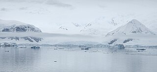
Posadowsky Glacier is a glacier about 9 nautical miles long, flowing north to Posadowsky Bay immediately east of Gaussberg. Posadowsky Bay is an open embayment, located just east of the West Ice Shelf and fronting on the Davis Sea in Kaiser Wilhelm II Land. Kaiser Wilhelm II Land is the part of East Antarctica lying between Cape Penck, at 87°43'E, and Cape Filchner, at 91°54'E, and is claimed by Australia as part of the Australian Antarctic Territory. Other notable geographic features in this area include Drygalski Island, located 45 mi NNE of Cape Filchner in the Davis Sea, and Mirny Station, a Russian scientific research station.
Bergel Rock is a rock nearly 1 nautical mile (1.9 km) south of Quintana Island in the southwestern Wilhelm Archipelago. It was named by the UK Antarctic Place-Names Committee for Alexandra Bergel, a granddaughter of Sir Ernest Shackleton, and a sponsor for HMS Endurance which made surveys in this area in February 1969.

Birley Glacier is a glacier, at least 10 nautical miles (19 km) long, flowing west into the eastern extremity of Barilari Bay north of Vardun Point, on the west coast of Graham Land. First seen and roughly surveyed in 1909 by the French Antarctic Expedition under Jean-Baptiste Charcot, it was re-surveyed in 1935–36 by the British Graham Land Expedition (BGLE) under John Rymill, and later named for Kenneth P. Birley, who contributed toward the cost of the BGLE, 1934–37.
Bolton Glacier is a glacier flowing into the head of Briand Fjord, Flandres Bay, on the west coast of Graham Land. It was mapped in 1959 by the Falkland Islands Dependencies Survey from photos taken by Hunting Aerosurveys Ltd in 1956–57, and named by the UK Antarctic Place-Names Committee for William B. Bolton (1848–89), English photographer who, with B.J. Sayce, invented the collodion emulsion process of dry-plate photography in 1864.

Breitfuss Glacier is a glacier 10 nautical miles (19 km) long, which flows southeast from Avery Plateau into Mill Inlet to the west of Cape Chavanne, on the east coast of Graham Land. It was charted by the Falkland Islands Dependencies Survey (FIDS) and photographed from the air by the Ronne Antarctic Research Expedition in 1947. It was named by the FIDS for Leonid Breitfuss, a German polar explorer, historian, and author of many polar bibliographies.
Cayley Glacier is a glacier flowing northwest into the south side of Brialmont Cove, on the west coast of Graham Land.

Chamberlin Glacier is a glacier on the east side of Hemimont Plateau which flows northeast into Whirlwind Inlet about 4 nautical miles (7 km) southeast of Matthes Glacier, on the east coast of Graham Land.
Wallend Glacier is a deeply entrenched glacier which drains eastward from Forbidden Plateau to join Green Glacier in northern Graham Land. Surveyed by Falkland Islands Dependencies Survey (FIDS) in 1955. So named by United Kingdom Antarctic Place-Names Committee (UK-APC) because the glacier is walled in on three sides by the escarpment of Forbidden Plateau.
The Darbel Islands are a group of islands and rocks extending southwest from Cape Bellue for 5 nautical miles (9 km) across the entrance to Darbel Bay, off the west coast of Graham Land. They were charted in 1930 by Discovery Investigations personnel on the Discovery II and named Marin Darbel Islands after the bay in which they were found. Both names have since been shortened by the UK Antarctic Place-Names Committee.
Davey Point is a conspicuous rocky headland 6 km (3.7 mi) south-west of Round Point on the north coast of King George Island, in the South Shetland Islands of Antarctica.
Dodman Island is an island 6.5 km (4.0 mi) long, lying 7.4 km (4.6 mi) south-east of Rabot Island and 18.5 km (11.5 mi) west of Ferin Head, off the west coast of Graham Land, Antarctica. The island was charted and named by the British Graham Land Expedition, 1934–37, under John Rymill.

Foley Glacier is a glacier about 4 nautical miles (7 km) long flowing north from the western end of Thurston Island just east of Cape Petersen. It was named by the Advisory Committee on Antarctic Names after Kevin M. Foley, of the United States Geological Survey, Reston, Virginia, a computer specialist and team member of the Glaciological and Coastal-Change Maps of Antarctica Project.
Franca Glacier named after Fernando E. Franca, is a glacier in Antarctica, flowing northeast into the head of Solberg Inlet, Bowman Coast, to the south of Houser Peak. The glacier was photographed from the air by the United States Antarctic Service, 1940, and the U.S. Navy, 1966. It was surveyed by the Falkland Islands Dependencies Survey, 1946–48, and named by the Advisory Committee on Antarctic Names in 1977 after Fernando E. Franca, Medical Officer and Station Manager, Palmer Station, 1974.
Green Glacier is a glacier on the east side of Graham Land, Antarctica, 15 nautical miles (28 km) long and 4 nautical miles (7 km) wide, flowing from the plateau northeast between Dugerjav Peak and Rugate Ridge, and then east into Vaughan Inlet next north of Pirne Peak and south of the terminus of Hektoria Glacier.
Link Stack is a rocky pillar at the northwest end of Chavez Island, off the west coast of Graham Land, Antarctica. It was charted by the British Graham Land Expedition under John Rymill, 1934–37. The stack was so named by the UK Antarctic Place-Names Committee in 1959 because it was here that the 1957 winter surveys by the Falkland Islands Dependencies Survey from the Prospect Point station were linked with the 1957–58 summer surveys by the British Naval Hydrographic Survey Unit.
Standifer Bluff is a conspicuous rock bluff, a component of the Smith Bluffs which form the northwest coast of Dustin Island, standing 10 nautical miles (18 km) west-southwest of the north tip of the island. The bluff was photographed from helicopters of the USS Burton Island and Glacier in the U.S. Navy Bellingshausen Sea Expedition, February 1960. Named by Advisory Committee on Antarctic Names (US-ACAN) for J.N. Standifer, United States Geological Survey (USGS) photographic specialist in Antarctica in the 1967–68 season.
References
- ↑ "Cornet Island". Geographic Names Information System . United States Geological Survey, United States Department of the Interior . Retrieved 26 November 2011.
![]() This article incorporates public domain material from "Cornet Island". Geographic Names Information System . United States Geological Survey.
This article incorporates public domain material from "Cornet Island". Geographic Names Information System . United States Geological Survey.
 | This Biscoe Islands location article is a stub. You can help Wikipedia by expanding it. |