
The William Jolly Bridge is a heritage-listed road bridge over the Brisbane River between North Quay in the Brisbane central business district and Grey Street in South Brisbane, within City of Brisbane, Queensland, Australia. It was designed by Harding Frew and built from 1928 to 1932 by MR Hornibrook.

Albert Bridge is a heritage-listed railway bridge of steel truss design crossing the Brisbane River between Indooroopilly and Chelmer in the City of Brisbane, Queensland, Australia. It was designed by Henry Charles Stanley and built from 1894 to 1895 by John McCormick & Son as a replacement for an earlier bridge lost to flooding in 1893. Both bridges were named in honour of the Prince of Wales, Prince Albert. It was added to the Queensland Heritage Register on 21 October 1992.

The Empire Theatre is a heritage-listed theatre at 56 & 56A Neil Street, Toowoomba, Toowoomba Region, Queensland, Australia. It was added to the Queensland Heritage Register on 31 May 1994.
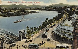
North Quay is a location in the Brisbane central business district and the name of a street in the same area, running along the Brisbane River from an intersection near Makerston Street to the top of the Queen Street mall, linking the Victoria Bridge and the William Jolly Bridge along the river's northern bank. It was the site of Brisbane’s initial settlement, at a point where a stream flowing from Spring Hill provided fresh water, later collected in a reservoir on Tank Street.

South Brisbane Dry Dock is a heritage-listed dry dock at 412 Stanley Street, South Brisbane, City of Brisbane, Queensland, Australia. It was designed by William David Nisbet and built from 1876 to 1887. It is also known as the Government Graving Dock. It was added to the Queensland Heritage Register on 21 October 1992.

Wynnum Wading Pool is a heritage-listed tidal pool on the foreshore of Moreton Bay at The Esplanade, Wynnum, City of Brisbane, Queensland, Australia. The shallow oval-shaped pool was built in 1932 by relief workers during the Great Depression and opened to the public in 1933. It is also known as Manly Wading Pool and Wynnum Wading Pool Reserve. It was added to the Queensland Heritage Register on 5 October 1998.

Chateau Nous is a heritage-listed villa at 1 Rupert Terrace, Ascot, Queensland, Australia. It was designed by Douglas Francis and Woodcraft Roberts. It was built from c. 1937 to 1940s. It was added to the Queensland Heritage Register on 21 October 1992.
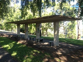
Newstead Air Raid Shelter is a heritage-listed former air raid shelter at Commercial Road, Teneriffe, City of Brisbane, Queensland, Australia. It was designed by Frank Gibson Costello and built c. 1942 by the Brisbane City Council. It was added to the Queensland Heritage Register on 6 April 2005.

Goldicott is a heritage-listed house, set on 1.23 hectares, located at 50 Grove Street, Toowong, Brisbane, Queensland, Australia. It was built from 1885 to c. 1918.

Raymond Park (West) Air Raid Shelter is a heritage-listed former air raid shelter in Raymond Park at 94 Baines Street, Kangaroo Point, Queensland, Australia. It was designed by Frank Gibson Costello and built c. 1942 by Brisbane City Council. It was added to the Queensland Heritage Register on 6 April 2005.
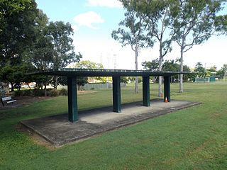
Raymond Park (East) Air Raid Shelter is a heritage-listed former air raid shelter in Raymond Park at 184 Wellington Road, Kangaroo Point, Queensland, Australia. It was designed by Frank Gibson Costello and built c. 1942 by Brisbane City Council. It was added to the Queensland Heritage Register on 6 April 2005.

Spring Hill Baths is a heritage-listed swimming pool at 14 Torrington Street, Spring Hill, City of Brisbane, Queensland, Australia. It was designed by Thomas Kirk and built from 1886 to 1913 by William M Park. It is also known as Arthur Street City Baths and Municipal Baths at Spring Hill. It was added to the Queensland Heritage Register on 21 October 1992.

Albert Park (North) air raid shelter is a heritage-listed former air raid shelter at Albert Park, Wickham Terrace, Spring Hill, City of Brisbane, Queensland, Australia. It was designed by Frank Gibson Costello and built c. 1942 by Brisbane City Council. It was added to the Queensland Heritage Register on 31 May 2005.

William Street retaining wall is a heritage-listed embankment at William Street, Brisbane City, City of Brisbane, Queensland, Australia. It was built from 1889 to 1970s. It is also known as William Street & Queens Wharf Road retaining walls and North Quay porphry wall. It was added to the Queensland Heritage Register on 21 October 1992.

Petrie Bight Retaining Wall is a heritage-listed embankment at 443–501 Queen Street, Brisbane City, City of Brisbane, Queensland, Australia. It was built from 1881 to 1882 by Henry Patten. It was added to the Queensland Heritage Register on 21 October 1992.

The Heritage Hotel is a heritage-listed hotel at 230 Quay Street, Rockhampton, Rockhampton Region, Queensland, Australia. It was designed by John William Wilson and built in 1898 by John Kerslake Evans. It is also known as the Old Colonial Hotel and the Commercial Hotel. It was added to the Queensland Heritage Register on 21 October 1992.

Cahill's Stores is a heritage-listed commercial building at 232–234 Quay Street, Rockhampton, Rockhampton Region, Queensland, Australia. It was designed by John William Wilson and built in 1889. It is also known as Central Queensland Livestock Co-operative Society, Clarke's Building, Flamingos Nightclub, Stadium Nightclub, Dalgety & Co., WG Murray Ltd, Inglis Ltd, and Kerrisk Bros. It was added to the Queensland Heritage Register on 21 October 1992.

Humphery Railway Bridge is a heritage-listed railway bridge on the Mungar to Monto railway line at Humphery, North Burnett Region, Queensland, Australia. It was designed by William Pagan and built in 1913. It was added to the Queensland Heritage Register on 21 October 1992.

First Church of Christ, Scientist, Brisbane is a heritage-listed site at 273 North Quay, Brisbane City, City of Brisbane, Queensland, Australia. It was designed by Lucas and Cummings, Architects. It was added to the Queensland Heritage Register on 11 March 2016.

Ernest Junction railway tunnel is a heritage-listed former railway tunnel at 797 Ashmore Road, Molendinar, Gold Coast City, Queensland, Australia. It was built from 1885 to 1889 by the Queensland Railway Department. It was added to the Queensland Heritage Register on 3 May 2019.


