History
The establishment of the comune of Corpi Santi di Milano was decided by Empress Maria Theresa in 1757 and actuated by her son Joseph II in 1782. The comune was briefly annexed to Milan during Napoleonic rule, but regained its autonomy with the Kingdom of Lombardy–Venetia; it was annexed to Milan again in 1873.
Corpi Santi had an area of about 66 km2 [2] and it was roughly ring-shaped, centered on Milan, and extending for 6–7 km from the city walls outwards.
The rural area outside the walls of Milan, comprising the Corpi Santi comune, was rich of water (traversed by the Navigli canals, as well as a number of rivers including Olona, Lambro, and Seveso) and rural settlements such as cascine (farms) and borghi (small towns). Its economy of course depended on Milan; being so close to the city walls, farmers in Corpi Santi could dedicate to cultivating perishable but profitable vegetables such as onion, cabbage, fruit. Goods brought to Milan from Corpi Santi were not subject to duty taxes.
In the 20th century, most of the territory of the Corpi Santi comune was absorbed into the urban agglomerate of Milan. Rural towns became districts; modern districts that developed from borghi of Corpi Santi include, for example, Barona, Gratosoglio, Ghisolfa, Bovisa, Calvairate, Tre Ronchetti, Monluè, Lorenteggio, Lampugnano, and Cimiano. Most cascine were either demolished or adapted for other functions, such as schools, restaurants, or government buildings.

Greco is a district ("quartiere") of Milan, Italy, part of the Zone 2 administrative division, located north-east of the city centre. Before being annexed to the city of Milan it was an independent comune, named Greco Milanese. As "Greco" is the Italian word for Greek, it has been suggested that the name refer to an old Greek settlement in the area; nevertheless, scholars tend to believe that the place was actually named after the Greco family that used to live here.
Taliedo is a peripheral district ("quartiere") of the city Milan, Italy, part of the Zone 4 administrative division, located south-east of the city centre. The informal boundaries of the district are three main city streets, respectively Via Mecenate, Via Bonfadini and Via Salomone.

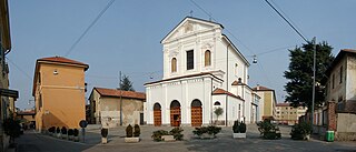
Calvairate is a district (quartiere) of Milan, Italy. It is part of the Zone 4 administrative division, located east of the city centre.

Nosedo is a district ("quartiere") of the city of Milan, Italy. It is part of the Zone 4 administrative division, located south of the city centre. Until 1870, it was an autonomous comune. The name comes from the Latin nocetum, meaning "walnut forest", as walnut trees used to be common in the area.
Vigentino is a district ("quartiere") of Milan, Italy, part of the Zone 5 administrative division, located south of the city centre. Before 1923, Vigentino was an autonomous, rural comune. By the mid 20th century, agricultural activities were dismissed, and the area was largely urbanized, with the construction of large apartment blocks.
Vaiano Valle is a rural district ("quartiere") of Milan, Italy, part of the Zone 5 administrative division. It is located south of the city's urban area, within the Parco Agricolo Sud Milano nature reserve. Before 1869, it was an autonomous comune.

Gratosoglio is a district (quartiere) of the city of Milan, Italy, part of the Zone 5 administrative division. It is located at southernmost end of the city, bordering on the comune of Rozzano, and it is traversed by the Lambro river.

Barona is a border district ("quartiere") of the city of Milan, Italy. It is part of the Zone 6 administrative division, and it is located south of the city centre. Its population can be roughly estimated to 85,000. It borders on the comunes of Buccinasco, Assago, and Corsico and the districts of Lorenteggio and Torretta. Its boundaries are marked by the Parco Agricolo Sud Milano nature reserve to the south, by the Naviglio Grande and Naviglio Pavese canals to the east and to the west, and by the Circonvallazione ring road to the north.

Giambellino and Lorenteggio are two historical and populous residential neighborhoods of Milan, Italy. Together, they form a district ("quartiere"), part of the Zone 6 administrative division of Milan.

Porta Magenta, formerly known as Porta Vercellina, was one of the city gates of Milan, Italy. The gate was established in the 9th century, with the Roman walls of the city; it was moved with the medieval and Spanish walls, and was finally demolished in the 19th century. The phrase "Porta Magenta" is now used to refer to the district ("quartiere") where the gate used to be; the district is part of the Zone 7 administrative division of Milan, west of the city centre.

Quarto Cagnino is a district (quartiere) of Milan, Italy, part of the Zone 7 administrative division of the city. It borders the districts of Trenno (north), San Siro (east), Baggio (south), and Quinto Romano (west). Before being annexed to Milan, in 1869, it was an autonomous comune and, briefly, a part of Trenno.

Baggio is a district (quartiere) of Milan, Italy, part of the Zone 7 administrative division of the city. Before being annexed to Milan in 1923, it was an autonomous comune.
Muggiano is a district (quartiere) of Milan, Italy, part of the Zone 7 administrative division of the city. It is located in western periphery, bordering on the comunes of Cesano Boscone, Cusago, Settimo Milanese, and Trezzano sul Naviglio. Before being annexed to Baggio, which in turn was annexed to Milan, Muggiano used to an autonomous comune.
Trenno is a district ("quartiere") of Milan, Italy, part of the Zone 8 administrative division of the city. It borders on green areas to the north and west and to the south ; to the east, it is adjacent to the Gallaratese district. Before being annexed to Milan, in 1923, it was an autonomous comune.

Affori is a ward of Milan, Italy, part of the Zone 9 administrative division of the city, located north of the city centre. It borders with the wards of Bruzzano, Comasina, Bovisasca, Dergano and Niguarda. Before being annexed to Milan in 1923, it was an autonomous comune.

In Italy, cascina a corte refers to a type of rural building traditional of the Po Valley, especially of Lombardy and of some areas of Piedmont and Emilia-Romagna.

The Oratorio di San Protaso is a church in via Lorenteggio, Milan, Lombardy.
Cascina Torchiera is a historic cascina a corte (farmhouse) of Milan, Italy, dating back to the first half of the 14th century. It is located in zone 8 of Milan, adjacent to the Maggiore cemetery, in the Musocco/Garegnano district, and is one of the oldest surviving cascine within the city boundaries. The cascina is formally the property of the Comune di Milano city administration and has been a squatted self-managed social centre since the 1992. It is known as Cascina Autogestita Torchiera SenzAcqua.

The Zone 3 of Milan, since 2016 officially Municipality 3 of Milan, is one of the 9 administrative administrative divisions of Milan, Italy.
Musocco is a district of Milan, located in the north-western outskirts of the city, belonging to Zone 8.
