
The province of Milan was a province in the Lombardy region of Italy. Its capital was the city of Milan. The area of the former province is highly urbanized, with more than 2,000 inhabitants/km2, the third highest population density among Italian provinces, just below the densities of the provinces of Naples and of Monza e Brianza, the latter of which was created in 2004 from the north-eastern part of the province of Milan. On 1 January 2015 the province was replaced by the Metropolitan City of Milan.
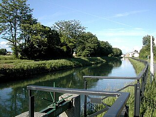
The Naviglio della Martesana is a canal in the Lombardy region, Northern Italy. Running from the Adda river, in the vicinity of Trezzo sull'Adda, to Milan, it was also known as Naviglio Piccolo. It is part of the system of navigli of the Milan area.
Rho is a town and comune (municipality) in the Metropolitan City of Milan in the Italian region of Lombardy, located about 14 kilometres northwest of Milan. The language spoken in Rho is Italian.

Cernusco sul Naviglio is a town and comune in the Metropolitan City of Milan, Lombardy, northwestern Italy. With a population of 33,436 as of 2015 it is the 14th-largest municipality in the metropolitan city.

The Naviglio Grande is a canal in Lombardy, northern Italy, connecting the Ticino river near Tornavento to the Porta Ticinese dock, also known as the Darsena, in Milan. It drops 34 m (112 ft) over 49.9 km (31.0 mi). It varies in width from 22 to 50 m from Tornavento to Abbiategrasso, dropping to 15 m (49 ft) between there and Milan. Initially it carries 63 cubic metres per second (2,200 cu ft/s), 116 outlets take water to irrigate 500 square kilometres (190 sq mi) leaving the canal 12 m (39 ft) wide and carrying 12 m3/s (420 cu ft/s) as it enters the dock.

The Naviglio Pavese is one of the canals making up the Navigli system in Lombardy, Italy. Once navigable, it is 33 km (21 mi) long and connected the city of Milan to Pavia, and through a flight of six locks to the River Ticino.

The Seveso is a 55-kilometre (34 mi) Italian river that flows through the provinces of Como, Monza e Brianza and Milan. It rises on Sasso di Cavallasca or Monte Sasso of Cavallasca, near San Fermo della Battaglia. From here its course runs through the communes Montano Lucino, Grandate, Civello, Casnate con Bernate, Portichetto, Fino Mornasco, Cucciago, Vertemate con Minoprio, Asnago, Carimate, Cimnago, Lentate sul Seveso, Camnago, Barlassina, Seveso, Cesano Maderno, Binzago, Bovisio-Masciago, Varedo, Palazzolo Milanese, Paderno Dugnano, Cusano Milanino, Cormano, Bresso. Finally, at Milan, it joins with the canal called the Naviglio Martesana which flows into the Lambro.

The Olona is an Italian river belonging to the Po Basin, 71 kilometres (44 mi) long, that runs through the Province of Varese and Metropolitan City of Milan whose course is developed entirely in Lombardy.
Milan is an ancient city in northern Italy first settled under the name Medhelanon in about 590 BC by a Celtic tribe belonging to the Insubres group and belonging to the Golasecca culture. It was conquered by the ancient Romans in 222 BC, who latinized the name of the city into Mediolanum. The city's role as a major political centre dates back to the late antiquity, when it served as the capital of the Western Roman Empire.

Lambrate is a district (quartiere) of Milan, Italy, located within the Zone 3 administrative division, six km (3.7 mi) north-east of the city centre. It owes its name to the Lambro river that traverses the area. Lambrate houses one of the major railway stations of north-eastern Milan, the Stazione di Milano Lambrate. The district is also well known for Parco Lambro, a large urban park established in 1934. The famous Lambretta motor scooter was manufactured in Lambrate, and named after this district, as is Birrificio Lambrate, a craft brewery established in 1996.

The Zone 2 of Milan, since 2016 officially Municipality 2 of Milan, is one of the 9 administrative divisions of Milan, Italy.
The city of Milan, Italy, has had three different systems of defending walls. The oldest, the Roman walls, were developed in two stages: the first in the Republican era and the second in the Imperial era. The second wall system was realized in the Middle Ages, after the destruction of the city by Frederick I Barbarossa. Finally, the latest wall system was built by the Spanish rulers in the 16th century. While very little remains of these walls, their structure is clearly reflected in the urbanistic layout of the city. In particular, modern Milan has two roughly circular rings of streets, namely the "Cerchia dei Navigli" and the "Cerchia dei Bastioni", which essentially correspond to the Medieval and Spanish walls, respectively. Note that a third ring of roads just beyond the Inner Ring Road, called the External Ring Road, does not follow any old city walls, but rather was part of the 1884 Beruto Plan for the city of Milan, created and named after a municipal engineer and public servant to the local city government.
Corpi Santi di Milano is a former Italian comune, established in 1782 and annexed to Milan in 1873. It comprised the rural territory around the city walls of Milan. It was originally known just as Corpi Santi; "di Milano" was added in 1859, possibly to avoid confusion with the comune with the same name located in the area of Pavia.
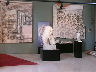
The Archaeological Museum of Milan is located in the ex-convent of the Monastero Maggiore, alongside the ancient church of San Maurizio al Monastero Maggiore, with entrance on Corso Magenta.

The Zone 6 of Milan, since 2016 officially Municipality 6 of Milan, is one of the 9 administrative divisions of Milan, Italy.

The following outline is provided as an overview of and topical guide to Milan:

The hydrography of Milan and the area of the neighboring municipalities is particularly complex, both for natural causes, given the conspicuous presence of rivers, streams and fountains that form a real water tangle, and for issues related to the work of canalization and diversion of waterways made by man, having their beginning during the Roman era, which led to the creation of numerous irrigation ditches, canals and lakes.

The term Alto Milanese, also called Altomilanese, is used to refer to the territory of Lombardy that includes the northwestern part of the metropolitan city of Milan, the southern part of the province of Varese and some municipalities in the southwestern part of the province of Como. It largely corresponds with one of the Italian provinces planned in the past: the province of Seprio. The Alto Milanese can be divided into four zones having their respective major cities as their main centers: the Bustese, Legnanese, Gallaratese and Saronnese. The major rivers of the Alto Milanese are the Olona and the Ticino, while among the noteworthy streams are the Arno, the Tenore, the Bozzente, the Lura, the Rile, and the Strona.


