
A broch is an Iron Age drystone hollow-walled structure found in Scotland. Brochs belong to the classification "complex Atlantic roundhouse" devised by Scottish archaeologists in the 1980s. Their origin is a matter of some controversy.

Rousay is a small, hilly island about 3 km (1.9 mi) north of Mainland, the largest island in the Orkney Islands of Scotland. It has been nicknamed "Egypt of the north", due to its archaeological diversity and importance.

The Brough of Birsay is an uninhabited tidal island off the north-west coast of The Mainland of Orkney, Scotland, in the parish of Birsay. It is located around 13 miles north of Stromness and features the remains of Pictish and Norse settlements as well as a modern light house.
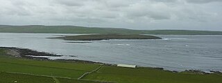
Eynhallow is a small, presently uninhabited island, part of Orkney, off the north coast of mainland Scotland.
Birsay is a parish in the north west corner of The Mainland of Orkney, Scotland. Almost all the land in the parish is devoted to agriculture: chiefly grassland used to rear beef cattle. There are various ancient monuments in the parish.

Sumburgh Head is a headland located at the southern tip of the Shetland Mainland in northern Scotland. The head consists of a 100 m high rocky spur and topped by the Sumburgh Head Lighthouse. In the Old Norse language, Sumburgh Head was called Dunrøstar høfdi, it means "The Head onto the loud tide-race", referring to the noise of Sumburgh Roost. Robert Stevenson was the engineer in charge of building the Sumburgh Head lighthouse. Work started on the building in 1819, and the light was first lit in 1821.

Evie is a parish and village on Mainland, Orkney, Scotland. The parish is located in the north-west of the Mainland, between Birsay and Rendall, forming the coastline opposite the isle of Rousay.

Mor Stein is a neolithic standing stone in the southeastern part of the island of Shapinsay, Orkney Islands, Scotland. Shapinsay is one of the two large inner islands of the Orkney group, and it is situated approximately two miles north of the Orkney Mainland. Linton Bay is situated slightly to the northeast of Mor Stein.
The Broch of Gurness is an Iron Age broch village on the northeast coast of Mainland Orkney in Scotland overlooking Eynhallow Sound, about 15 miles north-west of Kirkwall. It once housed a substantial community.

Eynhallow Sound is a seaway lying between Mainland Orkney and the island of Rousay in the Orkney Islands, Scotland. The tidal indraught is "scarcely felt beyond a line joining Costa Head and the Reef of Quendale". An Iron Age broch, Gurness, has a strategic outlook over the Eynhallow Sound.

The Point of Hellia is a headland on the northwest coast of the Orkney Mainland, Scotland. This landform extends into the southern part of Eynhallow Sound, a seaway of the North Sea.
The Sands of Evie is a sandy beach landform near the village of Evie on Mainland Orkney, Scotland, protected by the Point of Hellia headland. This beach forms the southern boundary of Aikerness Bay, an element of Eynhallow Sound. Immediately to the east is Gurness, a rather well preserved Iron Age broch. A Pictish slab was discovered on the Sands of Evie in 1967 and is now housed in Orkney Museum.
Aikerness Bay is an embayment of Eynhallow Sound on the northwest coast of Mainland Orkney, Scotland. The headlands of Point of Hellia at the east and Grit Ness at the west form the limit points of Aikerness Bay. The beach along the southern boundary of Aikerness Bay is known as the Sands of Evie. At the eastern end of Aikerness Bay is Gurness, an Iron Age broch.
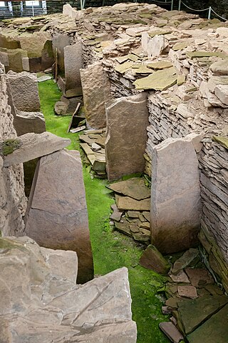
Midhowe Chambered Cairn is a large Neolithic chambered cairn located on the south shore of the island of Rousay, Orkney, Scotland. The name "Midhowe" comes from the Iron Age broch known as Midhowe Broch, that lies just west of the tomb. The broch got its name from the fact that it's the middle of three such structures that lie grouped within 500 metres (1,600 ft) of each other and Howe from the Old Norse word haugr meaning mound or barrow. Together, the broch and chambered cairn form part of a large complex of ancient structures on the shore of Eynhallow Sound separating Rousay from Mainland, Orkney.

Eynhallow Church is a ruined medieval church located on the uninhabited island of Eynhallow in Orkney, Scotland. The church dates back to the 12th-century and is thought to have originally been a monastery. Near the church are the building remains from a post-medieval village. Historic Environment Scotland first listed the site as a scheduled monument in 1921.

Blackhammer Chambered Cairn is a Neolithic chambered cairn located on the island of Rousay, in Orkney, Scotland. The tomb, constructed around 3000 BC, is a Orkney–Cromarty chambered cairn, characterized by stalled burial compartments. Historic Environment Scotland established the site as a scheduled monument in 1994.

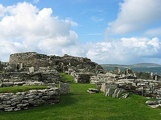
Midhowe Broch is an Iron Age broch located on the west coast of the island of Rousay in the Orkney Islands, in Scotland.
Tankerness is a district in the St Andrews parish in Mainland, Orkney, Scotland. Essentially a peninsula, it is about 13 kilometres (8 mi) south-east of Kirkwall and 1 kilometre (0.6 mi) east of Kirkwall Airport. The origin of the place name is uncertain, but it may derive from the Norse personal name "Tannskári". A "ness" is a promontory.

St Mary's Chapel, Wyre is a ruined 12th century chapel found on the island of Wyre, in Orkney, Scotland. It is thought to have been built by a Norse chieftain, Kolbeinn hrúga or his son, Bjarni Kolbeinsson, Bishop of Orkney. The now roofless Romanesque style building was originally constructed of local rubble and lime mortar. During the late 19th century, the building was restored. Historic Environment Scotland established the site, which includes the church and walled burial ground, as a scheduled monument in 1929.
