
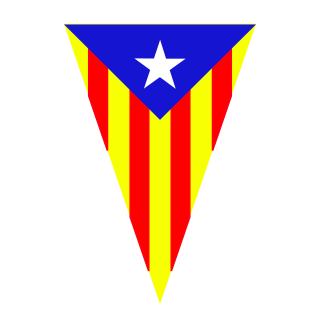
Catalonia is an autonomous community in the northeastern corner of Spain, designated as a nationality by its Statute of Autonomy.
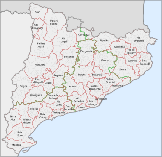
This is a list of the 42 comarques into which Catalonia is divided. A comarca is a group of municipalities, roughly equivalent to a "county" in the U.S.A. or the U.K. However, in the context of Catalonia, the term "county" can be a bit misleading, because in medieval Catalonia, aside from the kings of Aragon, the most important rulers were counts, notably the Counts of Barcelona and of Urgell. Comarques have no particular relation to the "counties" that were ruled by counts.
The Generalitat de Catalunya, or Government of Catalonia, is the institutional system by which Catalonia politically organizes its self-government. It is formed by the Parliament of Catalonia, the Presidency of the Generalitat de Catalunya, and the Executive Council of Catalonia

Sant Andreu de Llavaneres is a municipality located 36 km north of Barcelona (Catalonia) (Spain), along the Mediterranean coast, between Mataró and Sant Vicenç de Montalt. It belongs to the Maresme comarca and the Barcelona province. The short name is simply Llavaneres.
The Catalans are a Romance-speaking ethnic group native to Catalonia. The current official category of "Catalans" is that of the citizens of Catalonia, an autonomous community in Spain and the inhabitants of the Roussillon historical region in southern France, today the Pyrénées Orientales department, also called Northern Catalonia and Pays Catalan in French.

The Volta a Catalunya is a road bicycle race held annually in Catalonia, Spain.
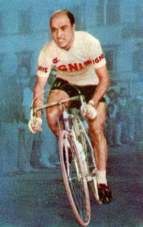
Miguel Poblet Orriols was a Spanish professional cyclist, who had over 200 professional victories from 1944 to 1962. He was the first Spanish rider to wear the yellow jersey in the Tour de France, and in 1956 he became the first of only three riders to win stages in the three Grand Tours in the same year. He won the Milan–San Remo classic race on two occasions and took 26 stage wins in the three Grand Tours. His twenty-stage wins in the Giro d'Italia makes him the third most successful foreign rider in the "Giro" behind Eddy Merckx (25) and Roger De Vlaeminck (22). Poblet was of short stature who had great power, he was the first Spanish rider to be a specialist in one day races in an age when Spain only produced climbers. He had a lightning fast sprint, but could also climb well, taking the Spanish Mountain championships on three occasions and the mountainous Volta a Catalunya twice. His nickname whilst riding was "La Flecha Amarilla" due to the yellow kit of his Ignis team.

Pica d'Estats is a 3,143-metre-high (10,312 ft) mountain in the Montcalm Massif, Pyrenees. on the Spanish–French border, and is the highest mountain in Catalonia.
Santa Maragarida de Montbui is a municipality in the comarca of the Anoia in Catalonia, Spain. It is situated in the Òdena Basin, immediately to the west of Igualada of which it effectively forms a suburb. The ajuntament is in Sant Maure. Other neighbourhoods in Montbui are the Old Town, el Saió-Coll del Guix and La Mallola.
Fígols is a municipality in the comarca of the Berguedà in Catalonia, Spain. It is situated to the north of Cercs, in the mountains above the Llobregat valley. Deposits of lignite are extracted commercially.

Saldes is a municipality in the comarca of the Berguedà in Catalonia, Spain. It is situated at the foot of the Pedraforca mountain (2497 m) in the north of the comarca. Deposits of lignite are extracted commercially. The village is linked to Guardiola de Berguedà by a local road. The monastery Sant Sebastià del Sull is located in Saldes.

Arbolí is a municipality in the comarca of the Baix Camp in Catalonia, Spain. It is situated in the west of the comarca in the Prades mountains. A local road links the village with the C-242 road.

C-16 or Eix del Llobregat is a primary highway in Catalonia, Spain. It is also part of the European route E9, from Orléans (France) to Barcelona.
Estat Català is a pro-independence nationalist historical political party of Catalonia (Spain).

Borredà is a municipality in the comarca of the Berguedà in Catalonia, Spain. It is situated in the upper valley of the Margençol river in the east of the comarca. There are several notable houses from the 17th and 18th centuries. The Romanesque church of Sant Sadurní de Rotgers, a protected historico-artistic monument, can be reached by a mountain track. The village is served by the C-149 road between Berga and Sant Quirze de Besora. The municipality surrounds an exclave of Les Llosses.
The following outline is provided as an overview of and topical guide to Catalonia:

Vilaverd is a municipality in the comarca of the Conca de Barberà in Catalonia, Spain.

Muntanya de Santa Bàrbara is a mountain that is part of the northwestern foothills of the Ports de Tortosa-Beseit, Catalonia, Spain. It has an elevation of 751.3 metres above sea level.
The Albera Massif is a mountain range located in the south of Pyrénées-Orientales and the north of Catalonia, between France and Spain. It is the main easternmost prolongation of the Pyrenees. Its highest peak is the Puig Neulós, with an elevation of 1,256 metres.

