
Fenny Drayton is a village and former civil parish, now in the parish of Witherley, in the Hinckley and Bosworth district of Leicestershire, England. It lies near the Warwickshire boundary, three miles south-east of Atherstone in the Coventry postcode area, just off the A444, the Roman Watling Street. Another Roman road crosses at the end of the scenic Fenn Lanes. The village is four miles from Stoke Golding, where Henry VII of England was crowned after the Battle of Bosworth in 1485. The reinterment of Richard III of England on 21 March 2015 started along Fenn Lanes, near the village. In 1931 the parish had a population of 125. On 1 April 1935 the parish was abolished and merged with Witherley, parts also went to Hartshill, Mancetter and Caldecote. The name means "farm/settlement for portage" or "farm/settlement used as a dragging place". "Fenny" reflects the fen-like ground along the Roman road.

Cropston is a village and former civil parish, now in the parish of Thurcaston and Cropston, part of the Borough of Charnwood in Leicestershire, England. It is on the edge of Charnwood Forest, and lies close to Bradgate Park. In 1931 the parish had a population of 404.
Thurcaston is a village and former civil parish, now in the parish of Thurcaston and Cropston, in the Charnwood district, in Leicestershire, England. It was the home of Bishop Hugh Latimer.

Garthorpe is a village and civil parish in Leicestershire, England, in the Melton district. It is about five miles east of Melton Mowbray. The parish includes the villages of Garthorpe and Coston, and is near Saxby, Wymondham, Buckminster and Sproxton.
Croxton Kerrial is a village and civil parish in the Melton borough of Leicestershire, England, 6.6 miles (10.6 km) south-west of Grantham, 7.9 miles (12.7 km) north-east of Melton Mowbray, and 0.5 miles (0.8 km) west of Leicestershire's border with Lincolnshire. The civil parish includes the village of Branston and had a population of 530 at the 2011 census.

Great Dalby is a village and former civil parish, now in the parish of Burton and Dalby, in the Melton district, in the county of Leicestershire, England, with a population of between 300 and 400. It is referred to in some UK census records as Dalby Magna. It is 3 miles south of Melton Mowbray.

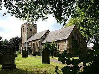
Burrough-on-the Hill is a small village and former civil parish, now in the parish of Somerby, in the Melton district, in the county of Leicestershire, England. It is 12 miles (19 km) north east of Leicester. The parish church is St. Mary the Virgin. Burrough Hill is an Iron Age hill fort near the village and is in an 86-acre (35 ha) country park of the same name. The hillfort stands on a promontory around 660 feet (200 m) above sea level, 7 miles (11 km) south of the modern settlement of Melton Mowbray. In 1931 the parish had a population of 214.

Runhall is a village and former civil parish, now in the parish of Brandon Parva, Coston, Runhall and Welborne, in the South Norfolk district, in Norfolk, England. The parish covers an area of 11.98 km2 (4.63 sq mi) and had a population of 365 in 137 households at the 2001 census, including Welborne and increasing in the 2011 Census to a population of 401 in 148 households.

Welborne is a village and former civil parish, now in the parish of Brandon Parva, Coston, Runhall and Welborne, in the South Norfolk district, in the county of Norfolk, England. In 1931 the parish had a population of 147.

Stonesby is a village and former civil parish, now in the parish of Sproxton, within the Melton borough of Leicestershire, England. It is 6 miles (9.7 km) northeast of Melton Mowbray, and 1.5 miles (2.4 km) southeast of Waltham on the Wolds. In 1931 the parish had a population of 140.

Barsby is a village and former civil parish now in the parish of Gaddesby, in the Melton district, in the county of Leicestershire, England. In 1931 the parish had a population of 162. The surname derives from the village.
Brooksby is a deserted village and former civil parish, now in the parish of Hoby with Rotherby, in the Melton district, in Leicestershire, England. It was the ancestral home of the Villiers family. Brooksby and surrounding villages were served by Brooksby railway station. In 1931 the parish had a population of 69.

Congerstone is a village and former civil parish, now in the parish of Shackerstone, in the Hinckley and Bosworth district, in Leicestershire, England. It is three miles north west of Market Bosworth, of which it was historically a daughter parish. It is near the Ashby-de-la-Zouch Canal and the A444 road. In 1931 the parish had a population of 209.

Saltby is a village and former civil parish, now in the parish of Sproxton, in the Melton borough of Leicestershire, England. It lies close to the River Eye and the border with Lincolnshire. There are approximately 65 properties (2021) within the village. In 1931 the parish had a population of 170. On 1 April 1936 the parish was abolished and merged with Sproxton.

Twyford is a village and former civil parish, now in the parish of Twyford and Thorpe, in the Melton district, in the county of Leicestershire, England. The name is derived from the two fords in the village. There are two churches in the village; St Andrew, which is a Grade I listed building with some parts dated from the 12th century, and a Methodist church. The village is in the south of the parish of Twyford and Thorpe. In 1931 the parish had a population of 282. On 1 April 1936 the parish was abolished to from "Twyford and Thorpe".

Branston is a village and former civil parish, now in the parish of Croxton Kerrial in the Melton district, in the county of Leicestershire, England. It lies 1 mile (1.6 km) north of the A607 road, 7 miles (11 km) south-west of Grantham and 7 miles north-east of Melton Mowbray, on the southern edge of the Vale of Belvoir, 3 miles (5 km) south-west of Belvoir Castle. Knipton Reservoir is 700 yards (640 m) to the north. In 1931 the parish had a population of 249.

Foston is a deserted medieval village and former civil parish, now in the parish of Kilby, in the Blaby district of Leicestershire and lies approximately 6.1 miles (9.8 km) south of the city of Leicester, England. The settlement name Foston means "Fotr's farm/settlement": "Fotr" is an Old Norse personal name, and "tūn" in Old English means an enclosure, farmstead, village or estate. In 1931 the parish of Foston had a population of 36. On 1 April 1935 the parish was abolished and merged with Kilby.

Cold Overton is a village and former civil parish, now in the parish of Knossington and Cold Overton, in the Melton district of Leicestershire, England. It is close to the border with Rutland, and approximately 3 miles (5 km) west from the market and county town of Oakham, and 1.5 miles (2.4 km) south-west of the A606 road. In 1931 the parish had a population of 133.

Coston is a village and former civil parish, now in the parish of Brandon Parva, Coston, Runhall and Welborne, in the South Norfolk district, in the county of Norfolk, England. The village is divided from nearby Runhall by the River Yare. In 1931 the parish had a population of 33.

Shoby is a hamlet and former civil parish 12 miles (19 km) north east of Leicester, now in the parish of Grimston, in the Melton district, in the county of Leicestershire, England. In 2000 it had an estimated population of 39. In 1931 the parish had a population of 49. Gregory Brokesby who was a resident of Shoby became the Sheriff of Leicestershire in 1632.

