A caldera is a large cauldron-like hollow that forms shortly after the emptying of a magma chamber in a volcanic eruption. An eruption that ejects large volumes of magma over a short period of time can cause significant detriment to the structural integrity of such a chamber, greatly diminishing its capacity to support its own roof, and any substrate or rock resting above. The ground surface then collapses into the emptied or partially emptied magma chamber, leaving a large depression at the surface. Although sometimes described as a crater, the feature is actually a type of sinkhole, as it is formed through subsidence and collapse rather than an explosion or impact. Compared to the thousands of volcanic eruptions that occur over the course of a century, the formation of a caldera is a rare event, occurring only a few times within a given window of 100 years. Only eight caldera-forming collapses are known to have occurred between 1911 and 2018, with a caldera collapse at Kīlauea, Hawaii in 2018. Volcanoes that have formed a caldera are sometimes described as "caldera volcanoes".

A volcano is a rupture in the crust of a planetary-mass object, such as Earth, that allows hot lava, volcanic ash, and gases to escape from a magma chamber below the surface. The process that forms volcanoes is called volcanism.

Popocatépetl is an active stratovolcano located in the states of Puebla, Morelos, and Mexico in central Mexico. It lies in the eastern half of the Trans-Mexican Volcanic Belt. At 5,393 m (17,694 ft) it is the second highest peak in Mexico, after Citlaltépetl at 5,636 m (18,491 ft).

The Ring of Fire is a tectonic belt of volcanoes and earthquakes.
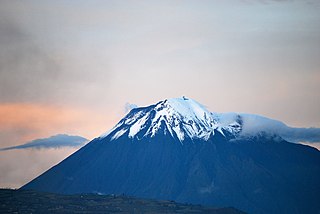
Tungurahua is an active stratovolcano located in the Cordillera Oriental of Ecuador. The volcano gives its name to the province of Tungurahua. Volcanic activity restarted on August 19, 1999, and is ongoing as of 2023, with several eruptive episodes since then, the most recent lasting from February 26 to March 16, 2016.

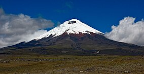
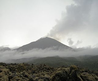
Cotopaxi is an active stratovolcano in the Andes Mountains, located near Latacunga city of Cotopaxi Province, about 50 km (31 mi) south of Quito, and 31 km (19 mi) northeast of the city of Latacunga, Ecuador. It is the second highest summit in Ecuador, reaching a height of 5,897 m (19,347 ft). Cotopaxi is among the highest active volcanoes in the world.
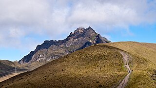
Pichincha is a stratovolcano in Ecuador. The capital Quito wraps around its eastern slopes.

Teide, or Mount Teide, is a volcano on Tenerife in the Canary Islands, Spain. Its summit is the highest point in Spain and the highest point above sea level in the islands of the Atlantic. If measured from the ocean floor, its height of 7,500 m (24,600 ft) makes Teide the third-highest volcano in the world, UNESCO and NASA rank it as Earth's third-tallest volcanic structure. Teide's elevation above sea level makes Tenerife the tenth highest island in the world.

Cotopaxi is one of the provinces of Ecuador. The capital is Latacunga. The province contains the Cotopaxi Volcano, an intermittent volcano with a height of 19,347 feet (5,897 m).

Latacunga is a plateau city of Ecuador, capital of the Cotopaxi Province, 89 km (55 mi) south of Quito, near the confluence of the Alaquez and Cutuchi rivers to form the Patate, the headstream of the Pastaza. At the time of census 2022 Latacunga had a population of 77,267 largely mestizo and indigenous.

Sangay is an active stratovolcano in central Ecuador. It exhibits mostly strombolian activity. Geologically, Sangay marks the southern boundary of the Northern Volcanic Zone, and its position straddling two major pieces of crust accounts for its high level of activity. Sangay's approximately 500,000-year-old history is one of instability; two previous versions of the mountain were destroyed in massive flank collapses, evidence of which still litters its surroundings today.
Reventador is an active stratovolcano which lies in the eastern Andes of Ecuador. It lies in a remote area of the national park of the same name, which is Spanish for "exploder". Since 1541, it has erupted over 25 times, although its isolated location means that many of its eruptions have gone unreported.

Mejía is a canton in the province of Pichincha in northern Ecuador. It is named after Ecuadorian political figure José Mejía Lequerica. The canton includes a volcano in the Central Cordillera of the Ecuadorian Andes called Rumiñahui. The seat of the canton is called Machachi.

Quilotoa is a water-filled crater lake and the most western volcano in the Ecuadorian Andes. The 3-kilometre (2 mi)-wide caldera was formed by the collapse of this dacite volcano following a catastrophic VEI-6 eruption about 800 years ago, which produced pyroclastic flows and lahars that reached the Pacific Ocean, and spread an airborne deposit of volcanic ash throughout the northern Andes. This last eruption followed a dormancy period of 14,000 years and is known as the 1280 Plinian eruption. The fourth eruptive phase was phreatomagmatic, indicating that a Crater lake was already present at that time. The caldera has since accumulated a 250-metre-deep (820 ft) crater lake, which has a greenish color as a result of dissolved minerals. Fumaroles are found on the lake floor and hot springs occur on the eastern flank of the volcano.

Kaimondake, or Mount Kaimon, is an undissected volcano – consisting of a basal stratovolcano and a small complex central lava dome – which rises to a height of 924 metres above sea level near the city of Ibusuki in southern Kyūshū, Japan. The last eruption occurred in the year 885 CE. Because of its conic shape, Mt. Kaimon is sometimes referred to as "the Fuji of Satsuma".
The National Polytechnic School, also known as EPN, is a public university in Quito, Ecuador. The campus, named after José Rubén Orellana, is located in the east-central part of Quito. It occupies an area of 15.2 hectares and has a built area of around 62,000 metres2. Its student body numbers approximately 10,000, of which thirty percent are women. The main campus encompasses ten teaching and research faculties, in addition to four technical and specialized institutes. EPN was founded in 1869 with the aim of becoming the first technical and technological center in the country. Since its beginnings, EPN adopted the polytechnic university model, which stresses laboratory instruction in applied science and engineering. At the campus, there are some libraries with content primarily oriented to engineering and scientific topics.

Sincholagua is an inactive volcano located in Ecuador 17 km (11 mi) northeast of Cotopaxi Volcano and 45 km (28 mi) southeast of Quito. It is the 12th highest peak in the country at 4,899 m (16,073 ft) but also one of the lesser known ones. The name of the mountain comes from the indigenous language Quichua and means "strong above". Due to its close proximity to Cotopaxi, the second highest peak in Ecuador and the most popular volcano, it is far less frequently visited compared to other mountains in the country. It has a sharp peak and at one point had glacial cover year round, but all of the glaciers melted a few decades ago. However, snow can still be seen on the peak since there is sometimes heavy snowfall at the summit.

Ecuador is a nation in northwest South America known as the Republic of Ecuador. Hundreds of thousands of kinds of plants and animals can be found there as a result of the diversity of its four zones. There are roughly 1640 bird species there. Along with the 4,500 kinds of butterflies, there are also 345 reptiles, 358 amphibians, and 258 mammals. Ecuador is regarded as one of the 17 nations with the highest concentration of biodiversity on Earth. The majority of its animals and plants are found in 26 state-protected areas. It also provides gastronomy, a range of cultures and customs, and historical attractions like Quito.

The Mama Negra is a traditional festival held twice a year in Latacunga, Cotopaxi Province, Ecuador. Also called La Santísima Tragedia, it is a celebration in honor of the Virgen de la Merced, who is said to have stopped an eruption of Cotopaxi volcano in 1742. The festival is also a celebration of the anniversary the city of Latacunga's independence.