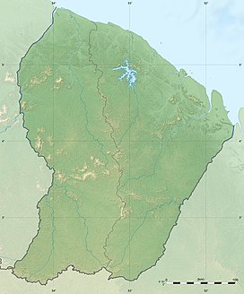
Transport in French Guiana consists of transport by road, boat, bus, and airplane. There is a railway line within the Guiana Space Centre to transport spacecraft. The road network is mainly concentrated in the coastal region. The interior of Guiana is accessed by plane or boat. There is one main airport, however there are several smaller airstrips in the interior.

The Aluku are a Bushinengue ethnic group living mainly on the riverbank in Maripasoula in southwest French Guiana. The group are sometimes called Boni, referring to the 18th-century leader, Bokilifu Boni.

Régina is a commune of French Guiana, an overseas region and department of France located in South America. With a land area of 12,130 km2 (4,680 sq mi), it is the second-largest commune of France. The town is named after the first merchant who settled in the area.

The Montagne d'Argent or Monte Prata is a hill in north-east French Guiana, next to Pointe Béhague, on the estuary of Oyapock River. In 1998, the mountain is protected by Conservatoire du littoral, because 22 petroglyphs had been discovered in the mountain. The hill rises to a height of 132 metres (433 ft).

Ouanary is a commune of French Guiana, an overseas region and department of France located in South America. Ouanary lies at the mouth of the river Oiapoque. Ouanary is the least populated commune of French Guiana. The settlement of Ouanary is accessible only by boat, helicopter, or light aircraft at Ouanary Airport, a 750 metres (2,460 ft) dirt runway.

Cottica Lawa is a village in the district of Sipaliwini, Suriname. It is located in the east, along the Marowijne River and the border with French Guiana. The village has a school, and a clinic.

Apatou is a commune in French Guiana, an overseas region and department of France in South America. Apatou is home to Maroons of the Aluku, Paramacca, Ndyuka, and Saramaka tribes.

Benzdorp is a village in the Sipaliwini District of Suriname. It is named after the English consul and bullion dealer H.J.W. Benz.

Maripasoula is a commune of French Guiana, an overseas region and department of France located in South America. With a land area of 18,360 km2 (7,090 sq mi), Maripasoula is the largest commune of France.
The Waki is a river in western French Guiana. It is a right tributary of the Tampok. It is 147 km (91 mi) long. The river has its source as the confluence of the southern Grande Waki which has its source in the Arawa Mountains, and the northern Petite Waki which has its source in the Sommet Tabulaire.

Papaichton is a commune in the overseas region and department of French Guiana. The village lies on the shores of the Lawa River. Papaichton is served by the Maripasoula Airport.

The Wayana are a Carib-speaking people located in the south-eastern part of the Guiana highlands, a region divided between Brazil, Surinam, and French Guiana. In 1980, when the last census took place, the Wayana numbered some 1,500 individuals, of which 150 in Brazil, among the Apalai, 400 in Surinam, and 1,000 in French Guiana, along the Maroni River. About half of them still speak their original language.

French Guiana is an overseas department/region and single territorial collectivity of France on the northern Atlantic coast of South America in the Guianas. It borders Brazil to the east and south and Suriname to the west.

Guiana Amazonian Park is the largest National Park of France, aiming at protecting part of the Amazonian forest located in French Guiana which covers 41% of the region. It is the largest park in France as well as the largest park in the European Union and one of the largest national parks in the world.

The Montagne d'Or mine is one of the largest gold mine projects in French Guiana, an overseas region of France. The mine is located in the north-west of the country in the Arrondissement of Saint-Laurent-du-Maroni. The mine has estimated reserves of 5,370,000 troy ounces (167,000 kg) of gold.

Surinamese Maroons are the descendants of enslaved Africans that escaped from the plantations and settled in the inland of Suriname and French Guiana. The Surinamese Maroon culture is one of the best-preserved pieces of cultural heritage outside of Africa. Colonial warfare, land grabs, natural disasters and migration have marked Maroon history. In Suriname six Maroon groups -or tribes- can be distinguished from each other.

Apatou was a guide, and Captain of the Aluku Maroons in French Guiana. Apatou founded the village of Moutendé which has been renamed Apatou. He mediated between France and Suriname with regards to the border, and allied the Aluku with France.

Boniville is a village of Aluku Maroons in the commune of Papaïchton located on the Lawa River in French Guiana.
Sainte-Rose-de-Lima is a village of Lokono Amerindians in the commune of Matoury in French Guiana. The village is located on the RN2 near Cayenne – Félix Eboué Airport. It is the largest settlement of Lokono in French Guiana.
The Lucifer Dékou-Dékou Biological Reserve is a wilderness area in French Guiana, France. The reserve is located in the communes of Apatou and Saint-Laurent-du-Maroni. It is the largest wilderness area of France, and consists of two separate parts, two mountain ranges covered in tropical rainforest; to the north are the Lucifer Mountains, to the south are the Dékou-Dékou Mountains. Controversially, the Montagne d'Or mine, the biggest mining project in France, is located in between the two ranges.


