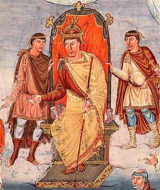
Charles the Bald, also known as Charles II, was a 9th-century king of West Francia (843–877), King of Italy (875–877) and emperor of the Carolingian Empire (875–877). After a series of civil wars during the reign of his father, Louis the Pious, Charles succeeded, by the Treaty of Verdun (843), in acquiring the western third of the empire. He was a grandson of Charlemagne and the youngest son of Louis the Pious by his second wife, Judith.

The Cottian Alps are a mountain range in the southwestern part of the Alps. They form the border between France and Italy (Piedmont). The Fréjus Road Tunnel and Fréjus Rail Tunnel between Modane and Susa are important transportation arteries between France and Italy (Turin).

The Pennine Alps French: Alpes Pennines, German: Walliser Alpen, Italian: Alpi Pennine, Latin: Alpes Poeninae), sometimes referred to as the Valais Alps, are a mountain range in the western part of the Alps. They are located in Italy and Switzerland (Valais).

Noricum is the Latin name for the kingdom or federation of tribes that included most of modern Austria and part of Slovenia. In the first century AD, it became a province of the Roman Empire. Its borders were the Danube to the north, Raetia and Vindelici to the west, Pannonia to the east and south-east, and Italia to the south. The kingdom was founded around 400 BC, and had its capital at the royal residence at Virunum on the Magdalensberg.

Roundheads were the supporters of the Parliament of England during the English Civil War (1642–1651). Also known as Parliamentarians, they fought against King Charles I of England and his supporters, known as the Cavaliers or Royalists, who claimed rule by absolute monarchy and the principle of the divine right of kings. The goal of the Roundheads was to give to Parliament the supreme control over executive administration of the country/kingdom.

Bithynia was an ancient region, kingdom and Roman province in the northwest of Asia Minor, adjoining the Sea of Marmara, the Bosporus, and the Black Sea. It bordered Mysia to the southwest, Paphlagonia to the northeast along the Pontic coast, and Phrygia to the southeast towards the interior of Asia Minor.

Neustria was the western part of the Kingdom of the Franks during the Early Middle Ages, in contrast to the eastern Frankish kingdom, Austrasia. It initially included land between the Loire and the Silva Carbonaria, in the north of present-day France, with Paris, Orléans, Tours, Soissons as its main cities. The population was therefore originally largely Romanised.
Mysia was a region in the northwest of ancient Asia Minor. It was located on the south coast of the Sea of Marmara. It was bounded by Bithynia on the east, Phrygia on the southeast, Lydia on the south, Aeolis on the southwest, Troad on the west, and the Propontis on the north. In ancient times it was inhabited by the Mysians, Phrygians, Aeolian Greeks and other groups.

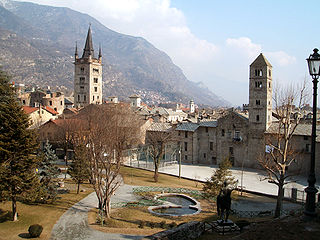
Aosta is the principal city of the Aosta Valley, a bilingual region in the Italian Alps, 110 km (68 mi) north-northwest of Turin. It is situated near the Italian entrance of the Mont Blanc Tunnel, at the confluence of the Buthier and the Dora Baltea, and at the junction of the Great and Little St Bernard Pass routes.

The Bosporan Kingdom, also known as the Kingdom of the Cimmerian Bosporus, was an ancient Greco-Scythian state located in eastern Crimea and the Taman Peninsula on the shores of the Cimmerian Bosporus, centered in the present-day Strait of Kerch. It was the first truly 'Hellenistic' state, in the sense that a mixed population adopted the Greek language and civilization, under aristocratic consolidated leadership. Under the Spartocid dynasty, the aristocracy of the kingdom adopted a double nature of presenting themselves as archons to Greek subjects and as kings to barbarians, which some historians consider unique in ancient history. The Bosporan Kingdom became the longest surviving Roman client kingdom. The 1st and 2nd centuries AD saw a period of a new golden age of the Bosporan state. It was briefly incorporated as part of the Roman province of Moesia Inferior from AD 63 to 68 under Emperor Nero, before being restored as a Roman client kingdom. At the end of the 2nd century AD, King Sauromates II inflicted a critical defeat on the Scythians and included all the territories of the Crimean Peninsula in the structure of his state.
Philon, Athenian architect of the 4th century BC, is known as the planner of two important works: the portico of twelve Doric columns to the great Hall of the Mysteries at Eleusis and, under the administration of Lycurgus, an arsenal at Athens. Of the last we have exact knowledge from an inscription. E. A. Gardner observes that it "is perhaps known to us more in detail than any other lost monument of antiquity." It was to hold the rigging of the galleys; and was so contrived that all its contents were visible from a central hall, and so liable to the inspection of the Athenian democracy. He is known to have written books on the Athenian arsenal and on the proportions of temple buildings, but these are now lost.
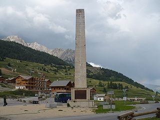
The Col de Montgenèvre is a high mountain pass in the Cottian Alps, in France 2 kilometres away from Italy.

The Alpes Cottiae was a small province of the Roman Empire founded in 63 AD by Emperor Nero. It was one of the three provinces straddling the Alps between modern France and Italy, along with the Alpes Graiae et Poeninae and Alpes Maritimae.
Marcus Julius Cottius was King of the Celtic and Ligurian inhabitants of the mountainous Roman province then known as Alpes Taurinae and now as the Cottian Alps early in the 1st century BC. Son and successor to King Donnus, he negotiated a dependent status with Emperor Augustus that preserved considerable autonomy for his country, making him a Roman governor, and adopted Roman citizenship.

Caiazzo is a city and comune in the province of Caserta (Campania) in Italy. It is located on the right bank of the Volturnus, some 20 kilometres (12 mi) northeast of Capua.

The Susa Valley is a valley in the Metropolitan City of Turin, Piedmont region of northern Italy, located between the Graian Alps in the north and the Cottian Alps in the south. It is one of the longest valleys of the Italian Alps. It extends over 50 kilometres (31 mi) in an east-west direction from the French border to the outskirts of Turin. The valley takes its name from the city of Susa which lies in the valley. The Dora Riparia river, a tributary of the Po, flows through the valley.

Orbetello is a town and comune in the province of Grosseto (Tuscany), Italy. It is located about 35 kilometres (22 mi) south of Grosseto, on the eponymous lagoon, which is home to an important Natural Reserve.

The Kingdom of Württemberg was a German state that existed from 1805 to 1918, located within the area that is now Baden-Württemberg. The kingdom was a continuation of the Duchy of Württemberg, which existed from 1495 to 1805. Prior to 1495, Württemberg was a county in the former Duchy of Swabia, which had dissolved after the death of Duke Conradin in 1268.
Hungary, the name in English for the European country, is an exonym derived from the Medieval Latin Hungaria. The Latin name itself derives from the ethnonyms (H)ungarī, Ungrī, and Ugrī for the steppe people that conquered the land today known as Hungary in the 9th and 10th centuries. Medieval authors denominated the Hungarians as Hungaria, but the Hungarians even contemporarily denominate themselves Magyars and their homeland Magyarország.
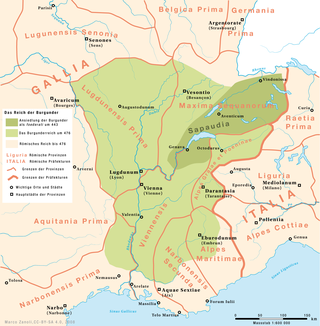
The Kingdom of the Burgundians or First Kingdom of Burgundy was established by Germanic Burgundians in the Rhineland and then in eastern Gaul in the 5th century.
