Cotton Hill, Illinois

Last updated

Cotton Hill
Marine Point toward Crows Mill.jpg
Waters of Lake Springfield above former site of Cotton Hill
USA Illinois location map.svg
Red pog.svg
Cotton Hill
Coordinates: 39°41′43″N89°37′44″W / 39.69528°N 89.62889°W / 39.69528; -89.62889
CountryUnited States
State Illinois
County Sangamon
Township Ball
Mill built1827
Razed and flooded1935
Named for Cotton Hill Township
Elevation
550 ft (170 m)

Cotton Hill, also known as Crow's Mill or Cotton Hill Post Office, was a small unincorporated community on the banks of Sugar Creek in Ball Township, Sangamon County, Illinois, about eight miles south of downtown Springfield. It stood for slightly over a century, from the 1820s until it was razed in the 1930s to make way for Lake Springfield. In 1900 the community had an estimated population of 150, a post office and a train station on the Illinois Central. [1] Just before its demolition in the 1930s the community had a store, a schoolhouse, a blacksmith's shop, and a gas station on Route 66. [2]

Contents

Name

The town was originally known as Crow's Mill for the gristmill around which the community took shape, which was acquired by the Crow family around 1850 and operated by them for many years. [3]

Despite the name "Cotton Hill", the town was not named directly for either a hill or a cotton crop. It acquired the name of Cotton Hill in the late 1860s, when the post office serving Ball and Cotton Hill townships was moved there from its initial location several miles away, on the boundary between the two townships. [4]

Business and economy

The Sugar Creek valley in which Cotton Hill is built, which lay along the Edwards Trace, attracted settlement from an early date. [5] The mill at Cotton Hill was first built in 1827 as a water-powered saw mill. It was the first water-powered mill in present-day Ball Township; earlier mills in the area had been horse mills. [3] The original sawmill was subsequently expanded to encompass a gristmill and a distillery, and to operate on both water and steam power. [3]

Around 1826, an extended family of potters including the Ebeys, Royals and Brunks established a pottery at Cotton Hill. [6] Located south of the town and above the present-day waters of Lake Springfield, the Ebey-Brunk pottery continued in operation until about 1854, and has been excavated as an archeological site. [7] The pottery specialized in large, utilitarian redware pots. [8]

In the 1830s a limestone quarry was dug near Crow's Mill. It provided the limestone for the Old State Capitol in Springfield. The limestone (known as Crow's Mill limestone) unfortunately turned an unsightly shade of brown after prolonged exposure to the atmosphere. [9] However, it continued to find various practical uses. When visited by the state geologist in 1912, the original Crow's Mill quarry was grown over and abandoned, but a new quarry had been established a quarter-mile to the west. [9]

Transportation

Railroad bridge just west of the site of Cotton Hill in Lake Springfield. IC bridge Lake Springfield.jpg
Railroad bridge just west of the site of Cotton Hill in Lake Springfield.

Cotton Hill had strong transportation connections even in the earliest days, thanks to its location on the Edwards Trace. In the 1830s and 1840s the stone blocks for the state capitol were hauled north to Springfield over the wagon roads by teams of ten to twelve oxen each. [10]

The railroad came to Cotton Hill in the late 1880s, with the establishment of the Chicago and St. Louis Railway, which later became the Jacksonville-Southeastern Railway, and in 1900 became the Litchfield division of the Illinois Central Railroad. The nearest stops to Cotton Hill Station were Glenarm six miles to the south and Gatton Station (later Toronto) one mile to the north. [11]

In 1901 the Illinois Central ceased service to Cotton Hill and began stopping a mile north at Gatton. The Cotton Hill post office was discontinued in 1907. [12] The road through Cotton Hill was named as a state aid highway in 1913, following the path that Route 66 would follow from 1930 to 1935, north to Springfield and south to Glenarm. [13]

Legacy

The former Crow's Mill schoolhouse at Cotton Hill, now the Crow's Mill Pub in Springfield. Crows mill pub.jpg
The former Crow's Mill schoolhouse at Cotton Hill, now the Crow's Mill Pub in Springfield.

The community's names lives on in the name of Cotton Hill Road, which follows the former alignment of Route 66 leading toward the town; [12] East and West Cottonhill Parks on the shores of Lake Springfield; [14] and the Crow's Mill Pub, a bar that occupies the relocated North Crow's Mill schoolhouse near Toronto. [15]

Crow's Mill limestone can be found not only in the Old State Capitol but in two "blanks" used for the capitol stones, which are preserved in parks on the shores of Lake Springfield. [16]

Related Research Articles

<span class="mw-page-title-main">Springfield, Illinois</span> Capital city of Illinois, United States

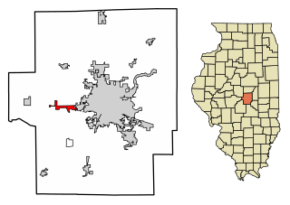
Springfield is the capital of the U.S. state of Illinois and the county seat of and most populous city in Sangamon County. The city's population was 114,394 at the 2020 census, which makes it the state's seventh most-populous city, the second largest outside of the Chicago metropolitan area, and the largest in central Illinois. Approximately 208,000 residents live in the Springfield metropolitan area.

<span class="mw-page-title-main">Sangamon County, Illinois</span> County in Illinois, United States

Sangamon County is located in the center of the U.S. state of Illinois. According to the 2020 census, it had a population of 196,343. Its county seat and largest city is Springfield, the state capital.

<span class="mw-page-title-main">Elkhart, Illinois</span> Village in Illinois, United States

Elkhart is a village in Logan County, Illinois, United States. The population was 405 at the 2010 census.

<span class="mw-page-title-main">Harristown, Illinois</span> Village in Illinois, United States

Harristown is a village in Macon County, Illinois, United States. The population was 1,310 at the 2020 census. It is included in the Decatur, Illinois Metropolitan Statistical Area.

<span class="mw-page-title-main">Auburn, Illinois</span> City in Illinois, United States

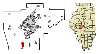
Auburn is a city in Sangamon County, Illinois, United States. The population was 4,771 at the 2010 census, and 4,681 in 2018. It is part of the Springfield, Illinois Metropolitan Statistical Area.

<span class="mw-page-title-main">Clear Lake, Illinois</span> Former village in Illinois, United States

Clear Lake is an unincorporated community and former incorporated village in Sangamon County, Illinois, United States. The population was 267 at the 2000 census. It is part of the Springfield, Illinois Metropolitan Statistical Area.

<span class="mw-page-title-main">Romeoville, Illinois</span> Village in Illinois, United States

Romeoville is a village in Will County, Illinois, United States. The village is located 26 mi (42 km) southwest of Chicago on the Gateway Wetlands, directly west of the Des Plaines River. Per the 2020 census, the population was 39,863. It is located in the southwest suburban area of Chicago near Interstate 55 and Interstate 355.

<span class="mw-page-title-main">Illinois State Capitol</span> State capitol building of the U.S. state of Illinois

The Illinois State Capitol, located in Springfield, Illinois, houses the legislative and executive branches of the government of the U.S. state of Illinois. The current building is the sixth to serve as the capitol building since Illinois was admitted to the United States in 1818. Built in the architectural styles of the French Renaissance and Italianate, it was designed by Cochrane and Garnsey, an architecture and design firm based in Chicago. Ground was broken for the new capitol on March 11, 1868, and the building was completed twenty years later for a total cost of $4.5 million.

New City is an unincorporated community in Cotton Hill Township, Sangamon County, Illinois, United States, in the rural center of the state. It is part of the Springfield, Illinois Metropolitan Statistical Area.

Glenwood High School is a public high school in Chatham, Illinois, United States. It is the only high school in Ball Chatham Community Unit School District 5, which is in southern Sangamon County and includes Chatham, Glenarm, and the southern portion of Springfield, Illinois.

<span class="mw-page-title-main">Old State Capitol State Historic Site</span> United States historic place

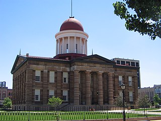
The Old State Capitol State Historic Site, in Springfield, Illinois, is the fifth capitol building built for the U.S. state of Illinois. It was built in the Greek Revival style in 1837–1840, and served as the state house from 1840 to 1876. It is the site of candidacy announcements by Abraham Lincoln in 1858 and Barack Obama in 2007. It was designated a National Historic Landmark in 1961, primarily for its association with Lincoln and his political rival Stephen Douglas.

<span class="mw-page-title-main">U.S. Route 66 in Illinois</span> Historic highway in Illinois

U.S. Route 66 was a United States Numbered Highway in Illinois that connected St. Louis, Missouri, and Chicago, Illinois. The historic Route 66, the Mother Road or Main Street of America, took long distance automobile travelers from Chicago to Southern California. The highway had previously been Illinois Route 4 and the road has now been largely replaced with Interstate 55 (I-55). Parts of the road still carry traffic and six separate portions of the roadbed have been listed on the National Register of Historic Places.

<span class="mw-page-title-main">Lake Springfield</span> Reservoir in Springfield, Illinois

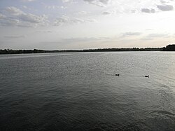
Lake Springfield is a 3,965-acre (16.05 km2) reservoir on the southeast edge of the city of Springfield, Illinois. It is 560 ft (170 m) above sea level. The lake was formed by building Spaulding Dam across Sugar Creek, a tributary of the Sangamon River. It is the largest municipally-owned body of water in Illinois. The lake and the lands adjoining it are all owned by City Water, Light & Power, the municipal utility for the city of Springfield, which operates the Dallman Power Plant at the lake's north end.

<span class="mw-page-title-main">Ball Township, Sangamon County, Illinois</span> Township in Illinois, United States

Ball Township is located in Sangamon County, Illinois. As of the 2010 census, its population was 6,701 and it contained 2,403 housing units. The township's offices are located in Glenarm. Portions of the village of Chatham are located in this township. Portions of Lake Springfield are also located in the township, including the former site of the flooded town of Cotton Hill.

<span class="mw-page-title-main">Sugar Creek (Sangamon River tributary)</span> River

Sugar Creek, a tributary of the Sangamon River, is a large creek in central Illinois, United States. It rises in Talkington Township in southwestern Sangamon County, flows briefly through northeastern Macoupin County, and then runs northeastward through south-central Sangamon County before discharging into Lake Springfield. The creek drains Auburn and Virden, Illinois and has a total length of 52.8 miles (85.0 km).

<span class="mw-page-title-main">Toronto, Illinois</span> Neighborhood in Sangamon County, Illinois, United States

Toronto is a neighborhood of Springfield, Illinois and a former unincorporated rural community located in Woodside Township. Originally named for a station on the Illinois Central Railroad, it is located adjacent to what is now the "Toronto Road" exit at Mile 90 of the Illinois section of Interstate 55. Today, the Toronto neighborhood of Springfield is roughly defined as the region bordering Lake Springfield south of Interstate 72 and east of Interstate 55.

Riddle Hill is a rural unincorporated community located in Curran and Gardner townships, Sangamon County, Illinois. It is a crossroads located adjacent to where Old Jacksonville Road crosses Little Spring Creek, 6.5 miles west of Springfield.

Buffalo Hart is an unincorporated community in northern Sangamon County in the U.S. state of Illinois. It is the population center of its own township, Buffalo Hart Township.

Cotton Hill is a fictional character on the television series King of the Hill.

References

  1. Official List of Officers, Agents, Stations, Attorneys, Surgeons, Etc. Illinois Central Railroad Company. November 1, 1900.
  2. Mazrim & Mann 2021, p. 15.
  3. 1 2 3 History of Sangamon County 1881, p. 792.
  4. History of Sangamon County, Illinois: Together with Sketches of Its Cities, Villages and Townships ... Portraits of Prominent Persons, and Biographies of Representative Citizens. Inter-state publishing Company. 1881. pp. 791–792.
  5. Mazrim 2008, p. 154.
  6. Mazrim, Robert (2008). The Sangamo Frontier: History and Archaeology in the Shadow of Lincoln. University of Chicago Press. pp. 184–185.
  7. Mazrim 2008, p. 185.
  8. Mazrim 2008, p. 189.
  9. 1 2 Crook, Alja Robinson (1912). Geology of Sangamon County. p. 17.
  10. Converse, Henry A. "House of the House Divided". Lincoln Centennial Association Papers. p. 42.
  11. The Official Railway Guide: North American Freight Service Edition. National Railway Publication Company. 1898. p. 575.
  12. 1 2 Hinckley, Jim (2020). Ghost Towns of Route 66: The Forgotten Places Along America's Famous Highway. Quarto Publishing Group USA. p. 28. ISBN   9780760369692.
  13. "Proposed State Aid Highways in Sangamon County, Illinois". Good Roads. December 20, 1913. p. 1.
  14. "Park Information". City Water Light & Power. Retrieved May 26, 2023.
  15. Nevel, Jason (September 2, 2016). "Fire-damaged schoolhouse-turned-tavern has loyal following". State Journal-Register. Retrieved May 26, 2023.
  16. Mazrim, Robert; Mann, Curtis (2021). Lake Springfield in Illinois: Public Works and Community Design in the Mid-Twentieth Century. Mount Pleasant, S.C.: America Through Time/Arcadia. p. 14. ISBN   9781634992930.