
Hazelton is a village located at the junction of the Bulkley and Skeena Rivers in northern British Columbia, Canada. It was founded in 1866 and in 2011 had a population of 305. The nearby larger community of New Hazelton is the northernmost point of the Yellowhead Highway, a major interprovincial highway which runs from Prince Rupert, British Columbia, to Portage la Prairie, Manitoba.

The Skeena River is the second-longest river entirely within British Columbia, Canada. Since ancient times, the Skeena has been an important transportation artery, particularly for the Tsimshian and the Gitxsan—whose names mean "inside the Skeena River" ,and "people of the Skeena River," respectively. The river and its basin sustain a wide variety of fish, wildlife, and vegetation, and communities native to the area depend on the health of the river. The Tsimshian migrated to the Lower Skeena River, and the Gitxsan occupy territory of the Upper Skeena.
Cottonwood River Provincial Park is a provincial park in British Columbia, Canada, located northeast of the confluence of the Fraser and Cottonwood Rivers in that province's North Cariboo region.

Kleanza Creek Provincial Park is a provincial park in British Columbia, Canada. Kleanza Creek is a tributary of the Skeena River. The park occupies over an area of 269 hectares.
Cottonwood Canyon may refer to:
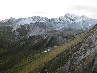
The Skeena Mountains, also known as the Skeenas, are a subrange of the Interior Mountains of northern British Columbia, Canada, essentially flanking the upper basin of the Skeena River. They lie just inland from the southern end of the Boundary Ranges of the Coast Mountains, and also of the northern end of the Kitimat Ranges. Their southern limit is described by the Bulkley River and the upper northwestern reaches of Babine and Takla Lakes, and on their northeast by the upper reaches of the Omineca River.

Twelve paddlewheel steamboats plied the upper Fraser River in British Columbia from 1863 until 1921. They were used for a variety of purposes: working on railroad construction, delivering mail, promoting real estate in infant townsites and bringing settlers in to a new frontier. They served the towns of Quesnel, Barkerville and Fort George. Some only worked the Fraser from Soda Creek to Quesnel, while others went all the way to Tête Jaune Cache or took the Nechako River and served Fort Fraser and beyond.

The British Columbia Interior, popularly referred to as the BC Interior or simply the Interior, is a geographic region of the Canadian province of British Columbia. While the exact boundaries are variously defined, the British Columbia Interior is generally defined to include the 14 regional districts that do not have coastline along the Pacific Ocean or Salish Sea, and are not part of the Lower Mainland. Other boundaries may exclude parts of or even entire regional districts, or expand the definition to include the regional districts of Fraser Valley, Squamish–Lillooet, and Kitimat–Stikine.

The Skeena River is British Columbia’s fastest flowing waterway, often rising as much as 17 feet (5.2 m) in a day and fluctuating as much as sixty feet between high and low water. For the steamboat captains, that wide range made it one of the toughest navigable rivers in British Columbia. Nevertheless, at least sixteen paddlewheel steamboats plied the Skeena River from the coast to Hazelton from 1864 to 1912.

The Nechacco sternwheeler was built for service on the Soda Creek to Fort George route on the upper Fraser River in British Columbia. She was owned by the Fort George Lumber and Navigation Company. The partners in this company were Nick Clark and Russel Peden of South Fort George, who operated a sawmill there. Nick Clark also owned the lots in that townsite and was offering them up for sale. The new steamer was intended to bring prospective property buyers to Fort George and to furnish them with supplies.

The Fort Fraser was a small sternwheeler owned by the Fort George Lumber and Transportation Company a partnership originally held by Nick Clarke and Russell Peden from the Fort George town-site of South Fort George. The Fort Fraser was intended to be a small prospecting craft that could service not only the Soda Creek to Fort George section of the upper Fraser River but also the Nechako River and some of its tributaries, enabling her to serve her namesake town of Fort Fraser.

The BC Express was a stern wheel paddle steamer (sternwheeler) that operated on the Fraser River in British Columbia, Canada, from 1912 to 1919. The BC Express was built for the BC Express Company by Alexander Watson, Jr to work on the upper Fraser River between Tête Jaune Cache and Fort George during the busy years of Grand Trunk Pacific Railway construction. The BC Express Company hired Captain Joseph Bucey, an experienced Skeena River pilot, to be her master.

The Inlander was a sternwheeler that worked on the Skeena River in British Columbia, Canada, from 1910 until 1912. She was owned by the Prince Rupert and Skeena River Navigation Company which was a syndicate of Skeena River businessmen who planned to use the Inlander as a passenger and freight steamer during the busy years of Grand Trunk Pacific Railway construction.

The Stikine Plateau is a plateau in northern British Columbia, Canada. It lies between the Boundary Ranges of the Coast Mountains on the west and southwest and the Cassiar Mountains along its northeast, and between the Skeena Mountains on its south and southeast and the Jennings and Nakina Rivers on the north.
Cottonwood Canyon is a canyon along the Fraser River in the North Cariboo region of the Central Interior of British Columbia, Canada. It is located west of the Cariboo Mountains on the Fraser River south of its confluence with the east-flowing West Road River and north of its confluence with the northwest-flowing Cottonwood River just northwest of the city of Quesnel, The first European explorer was Simon Fraser (explorer) who ran the rapids on the first of June, 1808. One of his canoes became stranded and had to be pulled out of the canyon with a rope. It was one of the obstacles for gold rush-era steamboats operating on the Fraser from Quesnel to Fort George and up the Nechako and Stuart Rivers to Stuart Lake.

Cottonwood, including the Cottonwood Ranch and Cottonwood House, is an unincorporated settlement in the North Cariboo region of the Central Interior of British Columbia, Canada. Originally a ranch, it is located in the northern Cariboo Plateau, just 8 km northwest of Coldspring House, which is at the confluence of the Swift River and Lightning Creek, which is the beginning of the Cottonwood River. Lightning Creek was one of the more famous of the gold-bearing creeks of the Cariboo Gold Rush.
Kitselas First Nation is the band government of the Kitselas subgroup of the Tsimshian. The band government is based at Gitaus in the Skeena Valley in the Skeena River valley to the northeast of the city of Terrace, British Columbia, Canada. Though there is no Tsimshian tribal council, they are a participant in the Tsimshian First Nations treaty council.
The Gitnadoix River is a tributary of the Skeena River in the province of British Columbia, Canada. It originates in the Kitimat Ranges, and flows about 38 km (24 mi) north to the Skeena River, about 45 km (28 mi) west of Terrace.
The Mosque River is a tributary of the Skeena River in the Stikine Region of the province of British Columbia, Canada. It originates in the Tatlatui Range of the Skeena Mountains, and flows southwest about 50 km (31 mi) to the Skeena River, about 140 km (87 mi) north of Hazelton and about 160 km (99 mi) east of Stewart. Its watershed covers about 148 km2 (57 sq mi), and its mean annual discharge is 15.4 m3/s (540 cu ft/s).
The Khyex River is a tributary of the Skeena River in the North Coast Regional District of the province of British Columbia, Canada. It originates in the Kitimat Ranges of the Coast Mountains, and flows south about 50 km (31 mi) to the lower tidal reach of the Skeena River, about 13 km (8.1 mi) upriver from Port Essington, 35 km (22 mi) southeast of Prince Rupert, and about 85 km (53 mi) southwest of Terrace. Its watershed covers 442 km2 (171 sq mi), and its mean annual discharge is 458.2 m3/s (16,180 cu ft/s).
