Worcestershire is a ceremonial county in the West Midlands of England. It is bordered by Shropshire, Staffordshire, and the West Midlands county to the north, Warwickshire to the east, Gloucestershire to the south, and Herefordshire to the west. The city of Worcester is the largest settlement and the county town.

The Malvern Hills are in the English counties of Worcestershire, Herefordshire and a small area of northern Gloucestershire, dominating the surrounding countryside and the towns and villages of the district of Malvern. The highest summit affords a panorama of the Severn Valley, the hills of Herefordshire and the Welsh mountains, parts of thirteen counties, the Bristol Channel, and the cathedrals of Worcester, Gloucester and Hereford.

Malvern is a spa town and civil parish in Worcestershire, England. It lies at the foot of the Malvern Hills, a designated Area of Outstanding Natural Beauty. The centre of Malvern, Great Malvern, is a historic conservation area, which grew dramatically in Victorian times due to the natural mineral water springs in the vicinity, including Malvern Water.

Malvern Hills is a local government district in Worcestershire, England. Its council is based in Malvern, the district's largest town. The district also includes the towns of Tenbury Wells and Upton-upon-Severn and a large rural area covering much of the western side of the county, including numerous villages. The district is named after the Malvern Hills, which are a designated Area of Outstanding Natural Beauty.

Tenbury Wells is a market town and civil parish in the northwestern extremity of the Malvern Hills District of Worcestershire, England. Its northern border adjoins Shropshire, and at the 2021 census joint with Burford it had a population of 5,224.

Great Malvern is an area of the civil parish of Malvern, in the Malvern Hills district, in the county of Worcestershire, England. It lies at the foot of the Malvern Hills, a designated Area of Outstanding Natural Beauty, on the eastern flanks of the Worcestershire Beacon and North Hill, and is the historic centre of Malvern and includes its town centre.

Anne Elizabeth Darwin was the second child and eldest daughter of Charles and Emma Darwin.

Hydrotherapy, formerly called hydropathy and also called water cure, is a branch of alternative medicine, occupational therapy, and physiotherapy, that involves the use of water for pain relief and treatment. The term encompasses a broad range of approaches and therapeutic methods that take advantage of the physical properties of water, such as temperature and pressure, to stimulate blood circulation, and treat the symptoms of certain diseases.

Barnards Green is one of the main population areas of Malvern, Worcestershire, England, situated approximately 1 mile (1.6 km) east and downhill from Great Malvern, the town's traditional centre.

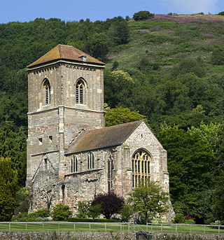
Little Malvern Priory, in the village of Little Malvern near Malvern, Worcestershire, was a Benedictine monastery c. 1171–1537. It was founded from Worcester Cathedral. Little remains of the 12th-century church, which was rebuilt in 1480–1482. The site is now occupied by a house named Little Malvern Court, which has limited public opening. The present building comprises a medieval chancel and crossing tower, and a modern west porch on the site of the east bays of the nave. The transepts and the two chapels flanking the choir are in ruins. The grade I listed Little Malvern Priory church, dedicated to St Giles, is adjacent.

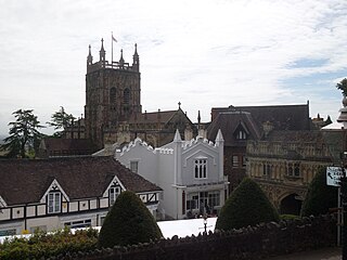
Great Malvern Priory in Malvern, Worcestershire, England, was a Benedictine monastery and is now an Anglican parish church. In 1949 it was designated a Grade I listed building. It is a dominant building in the Great Malvern Conservation area. It has the largest display of 15th-century stained glass in England, as well as carved misericords from the 15th and 16th century and the largest collection of medieval floor and wall tiles. In 1860 major restoration work was carried out by Sir George Gilbert Scott. It is also the venue for concerts and civic services.

West Worcestershire is a constituency in Worcestershire represented in the House of Commons of the UK Parliament since 2010 by Harriett Baldwin, a Conservative. The constituency is considered a safe seat for the Conservatives, having been a marginal with the Liberal Democrats from 1997 to 2010. The constituency boundaries roughly correspond with the Malvern Hills District.

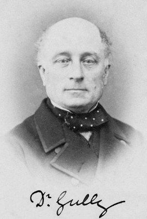
James Manby Gully was a Victorian medical doctor, well known for practising hydrotherapy, or the "water cure". Along with his partner James Wilson, he founded a very successful "hydropathy" clinic in Malvern, Worcestershire, which had many notable Victorians, including such figures as Charles Darwin and Alfred, Lord Tennyson, as clients.

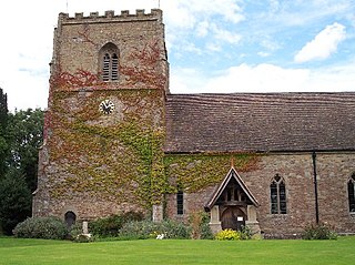
Cradley is a village in the civil parish of Cradley and Storridge, in Herefordshire, England. The nearest Herefordshire to Cradley towns are Ledbury, 9 miles (14 km) to the south and Bromyard, 9 miles to the north-west. The Worcestershire town of Malvern is 4 miles (6 km) to the south-east on the farther side of the Malvern Hills. Cradley and Storridge parish had a 2011 population of 1,667. On 12 October 2018 the parish was renamed from "Cradley" to "Cradley & Storridge".

St. Ann's Well is set on the slopes of the Malvern Hills above Great Malvern. It is a popular site on a path leading up to the Worcestershire Beacon and lies on the final descent of the Worcestershire Way. The spring or well is named after Saint Anne, the maternal grandmother of Christ and the patron saint of many wells. A building that dates back to 1813 houses the well or spring. Malvern water flows freely from an elaborately carved water spout. The building also hosts a cafe. During the early 20th century, the now-defunct Burrows company bottled and sold Malvern Water from this source under the "St Ann's Well" brand.

Ripple is a village and civil parish in the county of Worcestershire, England. Ripple is one of the most southerly parishes in the county and is situated on the A38 road with the River Severn as its western boundary. Besides Ripple, the parish contains the settlements of Holly Green, The Grove, Naunton, Ryall, Saxon's Lode, and Uckinghall. It had a combined population of 1,799 at the 2011 census.

Malvern water is a natural spring water from the Malvern Hills on the border of the counties of Herefordshire and Worcestershire in England. The Hills consist of very hard granite and limestone rock. Fissures in the rock retain rain water, which slowly permeates through, escaping at the springs. The springs release an average of about 60 litres a minute and the flow has never been known to cease.

The Malvern Museum in Great Malvern, the town centre of Malvern, Worcestershire, England, is located in the Priory Gatehouse, the former gateway to the Great Malvern Priory. The museum was established in 1979 and is owned and managed by the Malvern Museum Society Ltd, a registered charity. The Priory Gatehouse was a gift to the museum in 1980 from the de Vere Group, the owners of the neighbouring Abbey Hotel, and is staffed by volunteers. As such, the building itself is the museum's major exhibit.
Among the places of worship in the town and area of Malvern, Worcestershire are centres of dedication to many faiths and denominations. The town has 31 Christian churches with 11 belonging to the Church of England, ranging from low church to high Anglo-Catholic, two Roman Catholic, one Evangelical, and the others being Non-Conformist and other faiths. Its oldest place of worship is the almost cathedral sized parish church of Great Malvern Priory which is all that remains of the former 10th century abbey in central Malvern, which according to the Worcester Monastic Annals, work began in 1085. The chain of Malvern Hills lies in a north-south direction, thus posing a challenge for the architects of Christian churches located on the steep slopes, chancels being traditionally sited at the east end of the building. Many churches were built in the 19th century concomitant with the rapid expansion of the town due to its popularity as a spa. A few modern buildings such as St Mary's Church (1960) in Sherrard's Green, have been constructed in the second half of the 20th century, and some churches, notably St Andrews in Poolbrook, have had important modern extensions added during the first decade of the 21st century.

St Wulstan's Roman Catholic Church, Little Malvern, Worcestershire, England is a Benedictine parish church administered by the monks of Downside Abbey. The attached churchyard contains the grave of the composer Edward Elgar and of his wife, Alice. The church was designed in 1862 in a Gothic Revival style by Benjamin Bucknall. It is a Grade II listed building. The Elgars' grave has a separate Grade II listing.


