County Route 8 (Nassau County, New York)

Last updated

County Route 8

County Route 8 (Nassau County, New York)
CR 8 highlighted in red
Route information
Maintained by NCDPW
Length5.00 mi (8.05 km)
Existed1959 [1] –present
Location
Country United States
State New York
County Nassau
Highway system
Shelter Rock Road, as seen from Links Drive on September 18, 2021. Shelter Rock Road, North Hills, Long Island, New York September 18, 2021.jpg
Shelter Rock Road, as seen from Links Drive on September 18, 2021.

Nassau County Route 8 is an unsigned county road in Nassau County, New York. It travels between Old Country Road (CR 25) and Rockaway Avenue (CR E06) in Garden City and Northern Boulevard (NY 25A) in Manhasset.

Contents

Nassau County Route 8 travels along Herricks Road and Shelter Rock Road, is roughly five miles (8.0 km) in length, and is maintained by the Nassau County Department of Public Works. [2] [3]

Route description

The former shield for CR 8; all Nassau County routes have been unsigned since the 1970s. Nassau County 8 NY.svg
The former shield for CR 8; all Nassau County routes have been unsigned since the 1970s.

Southern segment (Herricks Road)

The route starts as Herricks Road at the intersection of Old Country Road (CR 25) and Rockaway Avenue (CR E06) in the Incorporated Village of Garden City (located within the Town of Hempstead). [2] [3] [5] [6] From there, it continues north underneath the Main Line of the Long Island Rail Road, entering into the Town of North Hempstead. [2] [3] [5] [6] From the railroad tracks, it continues north to Jericho Turnpike (NY 25), forming the boundary between the unincorporated hamlet of Garden City Park to the west and the Incorporated Village of Mineola to the east. [2] [3] [5] [6] Continuing north from Jericho Turnpike, County Route 8 continues north to Hillside Avenue (NY 25B), still as Herricks Road and forming the border between the two communities. [2] [3] [5] [6] North of Hillside Avenue, Herricks Road enters into the unincorporated hamlet of Herricks, and continues north through the hamlet to its intersection with Searingtown Road (CR 101) and Shelter Rock Road, where Herricks Road ends. [2] [3] [5] [6] At this intersection, the alignment of County Route 8 turns west onto Shelter Rock Road. [2] [3] [5] [6]

Northern segment (Shelter Rock Road)

Shelter Rock, as viewed from Shelter Rock Road. Shelter Rock Long Island.jpg
Shelter Rock, as viewed from Shelter Rock Road.

From the intersection with Herricks Road, Searingtown Road (CR 101), and Shelter Rock Road, Nassau County Route 8 follows Shelter Rock Road west and north through Herricks, passing Herricks High School and forming the border between Herricks and unincorporated Manhasset Hills, as well as some of the Herricks–North Hills village border. [2] [3] [5] [6] It continues north to I.U. Willets Road, entering completely into the Incorporated Village of North Hills. Continuing north, Shelter Rock Road crosses over the Northern State Parkway and then the Long Island Expressway (Interstate 495). [2] [3] [5] [6] [7] It then continues north through North Hills and then straddling the North Hills–Manhasset border, passing the historic Shelter Rock (for which the road is named), and ending just over the North Hills–Manhasset border at Northern Boulevard (NY 25A). [2] [3] [5] [6] [8] [9] [10] Additionally, when in use, the Long Island Motor Parkway crossed Shelter Rock Road. [11]

In the early 1960s, Shelter Rock Road's alignment was straightened and modernized through its northern stretch; remaining portions of the old alignment are now known as Old Shelter Rock Road. [5] [8] [12] [11]

Major intersections

Locationmi [13] kmDestinationsNotes
Garden CityMineola line0.00.0Rockaway Avenue (CR E06)Roadway continues as Old Country Road
Garden City ParkMineola line0.60.97NY-25.svg NY 25 (Jericho Turnpike) At-grade intersection
Garden City ParkHerricks
Williston ParkMineola quadripoint
1.21.9NY-25B.svg NY 25B (Hillside Avenue)At-grade intersection
Manhasset HillsSearingtown line2.173.49Old Courthouse Road
North Hills 2.654.26 I.U. Willets Road
3.15.0Northern Pkwy Shield.svg Northern State Parkway  Hauppauge, New York
3.25.1I-495.svg I-495  Riverhead, New York
Manhasset 5.08.0NY-25A.svg NY 25A (Northern Boulevard)At-grade intersection
1.000 mi = 1.609 km; 1.000 km = 0.621 mi

1982 Herricks Road train crash

On March 14, 1982, a Long Island Rail Road passenger train struck a van with 10 teenagers inside at the former Herricks Road grade crossing at 2:18 AM, killing the 19-year-old driver and 8 of the 9 passengers, while leaving the lone surviving van passenger in critical condition. [14] [15] [16] [17] The teenagers were attempting to beat the train and drove around the lowered gates when the train struck their van. [14] [15] [16] The National Transportation Safety Board labeled the Herricks Road grade crossing as being the most hazardous in the United States, what with an average of 20,000 cars and 200 trains traversing the grade crossing daily. [15] [16] [18]

Following the crash, the grade crossing at Herricks Road was eliminated. An underpass was constructed to allow CR 8 to travel underneath the Long Island Rail Road's Main Line instead of intersecting it at-grade. [14] [15] [18] [19] The bridge carrying the tracks over Herricks Road opened on April 28, 1998, after 5 years of construction. [15]

See also

Related Research Articles

<span class="mw-page-title-main">Albertson, New York</span> Hamlet and census-designated place in New York, United States

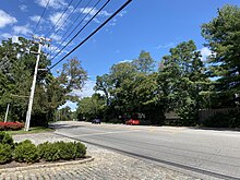
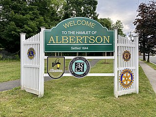
Albertson is a hamlet and census-designated place (CDP) in the Town of North Hempstead in Nassau County, on Long Island, in New York, United States. The population was 5,182 at the 2010 census.

<span class="mw-page-title-main">Flower Hill, New York</span> Village in New York, United States

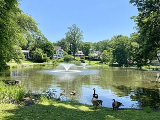
Flower Hill is a village in Nassau County, on the North Shore of Long Island, in New York, United States. The eastern half is considered part of the Greater Roslyn area, which is anchored by the Incorporated Village of Roslyn. Western and northern parts are more closely associated with Manhasset and Port Washington. The population was 4,794 at the time of the 2020 census.

<span class="mw-page-title-main">Herricks, New York</span> Hamlet and census-designated place in New York, United States

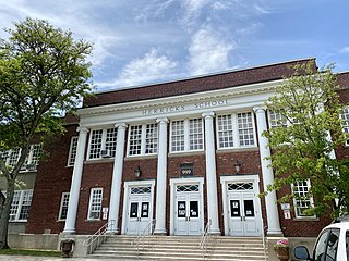
Herricks is a hamlet and census-designated place (CDP) in Nassau County, on Long Island, in New York, United States. The population was 4,398 at the 2020 census.

<span class="mw-page-title-main">Manhasset Hills, New York</span> Hamlet and census-designated place in New York, United States

Manhasset Hills is a hamlet and census-designated place (CDP) in the Town of North Hempstead in Nassau County, on Long Island, in New York, United States. The population was 3,592 at the 2010 census. Neighboring communities include Herricks, North Hills, North New Hyde Park, and Lake Success.

<span class="mw-page-title-main">North Hempstead, New York</span> Town in New York, United States

North Hempstead is one of three towns in Nassau County, on Long Island, in New York, United States. The population was 237,639 at the 2020 census.

<span class="mw-page-title-main">North Hills, New York</span> Village in New York, United States

North Hills is a village in the Town of North Hempstead in Nassau County, on the North Shore of Long Island, in New York, United States. The population was 5,464 at the 2020 census.

<span class="mw-page-title-main">Plandome Heights, New York</span> Village in New York, United States

Plandome Heights is a village in Nassau County, on the North Shore of Long Island, in New York, United States. It is considered part of the Greater Manhasset area, which is anchored by Manhasset. The population was 1,005 at the 2010 census.

<span class="mw-page-title-main">Roslyn Estates, New York</span> Village in New York, United States

Roslyn Estates is a village in the Town of North Hempstead in Nassau County, on the North Shore of Long Island, in New York, United States. It is considered part of the Greater Roslyn area, which is anchored by the Incorporated Village of Roslyn. The population was 1,318 at the 2020 census.

<span class="mw-page-title-main">Roslyn Heights, New York</span> Hamlet and census-designated place in New York, United States

Roslyn Heights is a hamlet and census-designated place (CDP) in the Town of North Hempstead in Nassau County, on the North Shore of Long Island, in New York, United States. It is considered part of the Greater Roslyn area, which is anchored by the Incorporated Village of Roslyn. The population was 6,747 at the time of the 2020 census.

<span class="mw-page-title-main">Searingtown, New York</span> Hamlet and census-designated place in New York, United States

Searingtown is a hamlet and census-designated place (CDP) in the Town of North Hempstead in Nassau County, on Long Island, in New York, United States. It is considered part of the Greater Roslyn area, which is anchored by the Village of Roslyn. The population was 4,915 at the 2010 census.

<span class="mw-page-title-main">New York State Route 25A</span> Queens-Calverton highway on Long Island

New York State Route 25A (NY 25A) is a state highway on Long Island in New York, United States. It serves as the main east–west route for most of the North Shore of Long Island, running for 73 miles (117 km) from Interstate 495 (I-495) at the Queens–Midtown Tunnel in the New York City borough of Queens to NY 25 in Calverton, Suffolk County. The highway is a northern alternate route of NY 25, which follows a more inland routing along Jericho Turnpike.

Old Country Road is a 17.57-mile-long (28.28 km) major east–west thoroughfare through central Nassau County and extending into western Suffolk County on Long Island, New York. It serves many of the major shopping centers in central Nassau County including Roosevelt Field Mall. The road also forms part of the border between the towns of Hempstead and North Hempstead. In Nassau County, Old Country Road is county-maintained as the unsigned County Route 25 (CR 25) west of Round Swamp Road. This road follows the boundary line separating the towns of Hempstead and North Hempstead.

<span class="mw-page-title-main">New York State Route 101</span> State highway in Nassau County, New York, United States

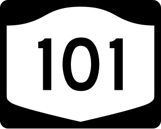
New York State Route 101 (NY 101) is a 3.58-mile (5.76 km) long state highway in northwestern Nassau County, New York, in the United States. It runs north–south as Port Washington Boulevard from NY 25A in Flower Hill, west of Roslyn and east of Manhasset, to Astor Lane in Sands Point. It becomes County Route 101 (CR 101) south along Searingtown Road to Shelter Rock Road (CR 8) and becomes Middle Neck Road north of Astor Lane, continuing north and west to a dead end at the Long Island Sound as the unsigned County Route D55 (CR D55).

<span class="mw-page-title-main">Strathmore, New York</span> Hamlet in New York, United States

Strathmore is an unincorporated, Levitt & Sons-developed hamlet in the Town of North Hempstead in Nassau County, on the North Shore of Long Island, in New York, United States, within the census-designated place (CDP) of Manhasset.

<span class="mw-page-title-main">Stonytown Road</span>

Stonytown Road is a 1.32-mile road in the incorporated villages of Flower Hill, Plandome, and Plandome Manor in the Town of North Hempstead, in Nassau County, on the North Shore of Long Island, in New York, United States. It serves as a major east-west through street across the Cow Neck Peninsula, between Plandome Road and North Plandome Road to the west and Port Washington Boulevard to the east – as well as forming portions of municipal boundaries.

<span class="mw-page-title-main">Plandome Road</span>

Plandome Road is a road in Manhasset and the incorporated villages of Plandome, Plandome Heights, and Plandome Manor in the Town of North Hempstead, in Nassau County, on the North Shore of Long Island, in New York, United States. It serves as a major north–south through street across the west side of the Cow Neck Peninsula, between Northern Boulevard to the south and Stonytown Road and North Plandome Road to the north, and is the main thoroughfare in downtown Manhasset.

<span class="mw-page-title-main">I.U. Willets Road</span> Road on Long Island, New York

I.U.Willets Road is a major west–east road between the Villages of North Hills and Old Westbury in the Town of North Hempstead, in Nassau County, on the North Shore of Long Island, in New York, United States.

<span class="mw-page-title-main">Manhasset Woods Road</span> Road in Nassau County, New York.

Manhasset Woods Road is a 1.16-mile (1.87 km) road in the incorporated villages of Flower Hill and Munsey Park in the Town of North Hempstead, in Nassau County, on the North Shore of Long Island, in New York, United States. It serves as a major north–south through street across the lower portion of the Cow Neck Peninsula, between Northern Boulevard to the south and Stonytown Road to the north.

References

  1. Nassau County Department of Public Works (1959). "Master Plan for Nassau County". Nassau County Department of Public Works.
  2. 1 2 3 4 5 6 7 8 9 10 "Nassau County Road Jurisdiction Viewer" (Map). nassau-county.maps.arcgis.com. Retrieved August 22, 2021.
  3. 1 2 3 4 5 6 7 8 9 10 New York State Department of Transportation (July 1, 2020). County Roads Listing – Nassau County (PDF) (Report). Retrieved August 22, 2021.
  4. "Nassau-Suffolk County Road History". NYC Roads. Archived from the original on January 3, 2009. Retrieved August 22, 2021.
  5. 1 2 3 4 5 6 7 8 9 10 "Long Island Index: Interactive Map". www.longislandindexmaps.org. Retrieved 2021-08-22.
  6. 1 2 3 4 5 6 7 8 9 "Nassau County Route 8 - Shelter Rock Road". East Coast Roads. Retrieved 2021-08-22.
  7. Galant, Richard (September 3, 1971). "Traffic Roar Backfires on Ears". Newsday . p. 6 via ProQuest.
  8. 1 2 Rather, John (1999-02-28). "Shelter Rock Facing an Uncertain Future". The New York Times. ISSN   0362-4331 . Retrieved 2021-08-22.
  9. Mosco, Steve (2015-09-20). "What is Shelter Rock?". Manhasset Press. Retrieved 2021-08-22.
  10. Hanscom, Leslie (July 28, 1971). "A 2,600-Ton Landmark Few Know". Newsday . p. 16 via ProQuest.
  11. 1 2 Pulitzer, Lisa (November 28, 1993). "Off a Historic Road, Decorators Show Off Historic Houses". The New York Times . p. LI13. Retrieved 2022-11-14.
  12. "County OKs $12 Million For '61 Road Program". Newsday . January 31, 1961. p. 15 via ProQuest.
  13. Google (September 3, 2021). "County Route 8 (Nassau County, New York)" (Map). Google Maps . Google. Retrieved September 3, 2021.
  14. 1 2 3 McQuiston, John T. (June 16, 1985). "Grade Crossing Plans Readied for Mineola: Crossing Plans Set". The New York Times . pp. 1, 4. Retrieved 2022-11-14.
  15. 1 2 3 4 5 Draffen, Duayne (April 28, 1998). "16 Years After Death of 9 Teen-Agers, Rail Bridge Opens". The New York Times. Retrieved May 29, 2016.
  16. 1 2 3 Bernstein, James (March 15, 1982). "Drivers Say Gates Often Balky". Newsday . p. 17 via ProQuest.
  17. Young, Gwen (June 3, 1991). "Deaths AND Delays: 9 Tragic Deaths Prod Mom In Quest of a Safer Crossing". Newsday . pp. 1, 3, 19 via ProQuest.
  18. 1 2 Morris, Tom (July 21, 1982). "NY Plan: Cut LIRR Crossings: NY Seeks to Cut LIRR Crossings $65-million proposal would eliminate Herricks Road crossing, 5 others in Mineola". Newsday . pp. 1, 3 via ProQuest.
  19. "... but after 20 perilous years, Mineola grade crossings are finally to be rebuilt". Newsday . March 22, 1993. p. 34 via ProQuest.