
Whidbey Island is the largest of the islands composing Island County, Washington, in the United States, and the largest island in Washington state. Whidbey is about 30 miles (48 km) north of Seattle, and lies between the Olympic Peninsula and the I-5 corridor of western Washington. The island forms the northern boundary of Puget Sound. It is home to Naval Air Station Whidbey Island. The state parks and natural forests are home to numerous old growth trees.

Island County is a county located in the U.S. state of Washington. As of the 2020 census, its population was 86,857. Its county seat is Coupeville, while its largest city is Oak Harbor.

Coupeville is a town on Whidbey Island, in Island County, Washington, United States.
Keystone is a small unincorporated community on Whidbey Island in Island County, Washington, in the northwestern United States. It is near the Keystone ferry landing, a dock at Keystone Harbor for the Washington State Ferries' Coupeville to Port Townsend route. The route provides a maritime link for State Route 20 across Admiralty Inlet to the Olympic Peninsula. Since its establishment in the 1930s, the ferry route to Port Townsend was known as the Keystone-Port Townsend Ferry; the name was changed in 2010 at the suggestion of the Central Whidbey Chamber of Commerce in order to avoid confusion from tourists and visitors to Whidbey Island.
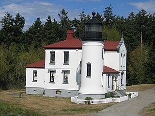
The Admiralty Head Light is a deactivated aid to navigation located on Whidbey Island near Coupeville, Island County, Washington, on the grounds of Fort Casey State Park. The restored lighthouse overlooks Admiralty Inlet. It was the companion to the Point Wilson Light, which sits four miles away on Admiralty Inlet's western shore.

Granville Owen Haller was a noted Indian fighter, United States Army officer, and wealthy post Civil War businessman who settled in northwest Washington state. During the American Civil War, he was charged with the defense of south-central Pennsylvania during the early days of Gettysburg Campaign prior to the arrival of the Army of the Potomac.

Ebey's Landing National Historical Reserve is a unit of the National Park Service on Whidbey Island in the Puget Sound, near Coupeville in Island County, Washington, United States.

Greenbank is an unincorporated community on Whidbey Island in Island County, Washington, United States.

Deception Pass Bridge is the common name for two two-lane bridges on Washington State Route 20 connecting Whidbey Island in Island County, to Fidalgo Island in Skagit County, in the U.S. state of Washington. It was a Washington State Highways project, and included project elements built by young workers from the Civilian Conservation Corps. Completion of the bridge was a factor in the decision to build Naval Air Station Whidbey Island and helped Oak Harbor flourish. The bridge is a commonly photographed landmark of the Puget Sound region.

Island Transit is a zero-fare transit system in Island County, Washington, serving Whidbey Island and Camano Island. The system consists of fixed-route bus service, paratransit, and vanpools, and carried a total of 974,899 passengers in 2015. Island Transit added Sunday service in May of 2023.

Naval Outlying Landing Field Coupeville—or NOLF Coupeville—(ICAO: KNRA, FAA LID: NRA) is a military airport located two miles (3 km) southeast of Coupeville, Washington, in Island County. The airfield is owned and operated by the United States Navy. NOLF Coupeville nearly touches State Route 20 and is about 10 miles south of the Whidbey Island Naval Air Station.
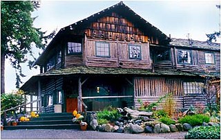
The Captain Whidbey Inn, a lodging and hospitality establishment built in 1907, is located on Whidbey Island at the west end of Penn Cove just outside Coupeville, Washington. It is part of the National Register of Historic Places listed Central Whidbey Island Historic District.

Fort Ebey State Park is a public recreation area occupying the site of former Fort Ebey on the west side of Whidbey Island, five miles (8.0 km) west of Coupeville in Island County, Washington, United States. The state park covers 651 acres (263 ha) overlooking the Strait of Juan de Fuca and lies within the Ebey's Landing National Historical Reserve. It is managed by the Washington State Parks and Recreation Commission.

One of the oldest residential buildings in Washington, the Ferry House was built in 1860 by Winfield Scott Ebey as an inn to provide financial stability for his brother's children, who were orphaned when Isacc Neff Ebey was assassinated by northern indigenous tribes. Once completed and opened for business, the building was named The Ebey Inn. The prime location across Admiralty Inlet from Port Townsend meant a steady flow of travelers and income for the three Ebey children. With no other nearby accommodations, the Inn — which housed a post office, a tavern, and rooms for overnight guests — quickly became an important place for sailors and other travelers to rest before continuing their journeys to Coupeville, Whidbey Island, La Conner, Washington, and points further north. Travelers and locals could also purchase merchandise and groceries at the Inn, which served ferry traffic to and from Port Townsend until a new ferry dock was constructed near Fort Casey at the turn of the 20th century. The house stayed in the Ebey family for 57 years, until Isaac Ebey's grandson sold the old Inn in 1917.

The Sergeant Clark House, built in 1892, is a Vernacular style farmhouse located in Ebey's Landing National Historical Reserve in Coupeville on Whidbey Island, Washington. The Queen Anne Style—Eastlake movement architecture represents application of structural detail and ornamentation, and an early period of community growth.

Captain Thomas Coupe was a ship's captain and early settler of Whidbey Island.
Coupeville School District 204 is a public school district headquartered in Coupeville, Washington, United States. It serves the central portion of Whidbey Island. As of the 2022-23 school year the district has an enrollment of 702 students.
Carl W. Leick was an architect who worked in the Northwest of the United States. He designed structures for 25 sites on the West Coast, including the Turn Point (1893), Patos (1908), and Lime Kiln (1914) lighthouses.

Glacial erratic boulders in Island County are a remnant of the Pleistocene glaciation that created Puget Sound and transformed the surfaces of what are now Island County's main landmasses: Whidbey Island and Camano Island. South of Deception Pass, the two islands' surfaces and beaches are completely composed of glacial till. Abundant glacial erratic boulders lie on the islands, their beaches, and under the near-shore waters.
Price Sculpture Forest is an outdoor collection of sculptures located east of Coupeville on Whidbey Island, Washington, United States. The land is 16.3 acres and contains just over a half mile of trails. The park features two path loops through a century-old forest; one is called Nature Nurtured and features sculptures that take inspiration from nature, while the other is called Whimsy Way and features more playful sculptures. It is managed by the non-profit Price Sculpture Forest, which was established by the Price family.

