
Offa's Dyke Path is a long-distance footpath loosely following the Wales–England border. Officially opened on 10 July 1971, by Lord Hunt, it is one of Britain's National Trails and draws walkers from throughout the world. About 60 miles (97 km) of the 177-mile (285 km) route either follows, or keeps close company with, the remnants of Offa's Dyke, an earthwork traditionally thought to have been constructed in the late 8th century on the orders of King Offa of Mercia.

The Berwyn range is an isolated and sparsely populated area of moorland in the northeast of Wales, roughly bounded by Llangollen in the northeast, Corwen in the northwest, Bala in the southwest, and Oswestry in the southeast.
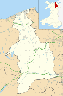
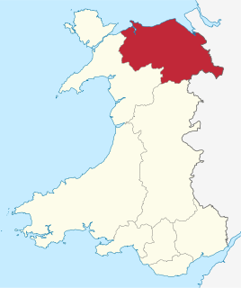
Denbighshire is a county in the north-east of Wales. Its borders differ from the historic county of the same name. This part of Wales contains the country's oldest known evidence of habitation – Pontnewydd (Bontnewydd-Llanelwy) Palaeolithic site has Neanderthal remains of some 225,000 years ago. Castles include Denbigh, Rhuddlan, Ruthin, Castell Dinas Bran and Bodelwyddan. St Asaph, one of Britain's smallest cities, has one of its smallest Anglican cathedrals.
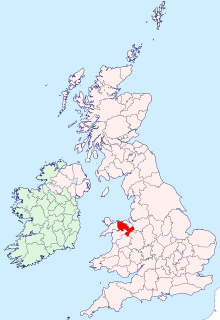
Historic Denbighshire is one of thirteen traditional counties in Wales, a vice-county and a former administrative county, which covers an area in north east Wales. It is a maritime county, bounded to the north by the Irish Sea, to the east by Flintshire, Cheshire and Shropshire, to the south by Montgomeryshire and Merionethshire, and to the west by Caernarfonshire.
Clwyd is a preserved county of Wales, situated in the north-east corner of the country; it is named after the River Clwyd, which runs through the area. To the north lies the Irish Sea, with the English ceremonial counties of Cheshire to the east and Shropshire to the south-east. Powys and Gwynedd lie to the south and west respectively. Clwyd also shares a maritime boundary with Merseyside along the River Dee. Between 1974 and 1996, a slightly different area had a county council, with local government functions shared with six district councils. In 1996, Clwyd was abolished, and the new principal areas of Conwy County Borough, Denbighshire, Flintshire and Wrexham County Borough were created; under this reorganisation, "Clwyd" became a preserved county, with the name being retained for certain ceremonial functions.

The River Dee is a river in the United Kingdom. It flows through parts of both Wales and England, forming part of the border between the two countries.

The Diocese of Saint Asaph is a diocese of the Church in Wales in north-east Wales, named after Saint Asaph, its second bishop.

The Clwydian Range is a series of hills in the north-east of Wales that runs from Llandegla in the south to Prestatyn in the north, the highest point being the popular Moel Famau. The range forms part of the Clwydian Range and Dee Valley Area of Outstanding Natural Beauty.

Clwyd South is a constituency of the Senedd. It elects one Member of the Senedd by the first past the post method of election. Also, however, it is one of nine constituencies in the North Wales electoral region, which elects four additional members, in addition to nine constituency members, to produce a degree of proportional representation for the region as a whole.

The Ruabon Moors are an area of upland moorland in Wales to the west of Ruabon and Wrexham. They lie partly within Wrexham County Borough and partly within Denbighshire.

The Eglwyseg valley is an area to the north east of Llangollen in Denbighshire, Wales; it is within the boundaries of Llantysilio Community. The name also refers to a widely scattered hamlet in the valley.

The Horseshoe Pass is a mountain pass in Denbighshire, north-east Wales. It separates Llantysilio Mountain to the west from the 565 metre mountain and Marilyn Cyrn-y-Brain to the east. The A542 road from Llandegla to Llangollen runs through the pass, reaching a maximum height of 417 metres (1,368 ft). The road travels in a horseshoe shape around the sides of a valley, giving the pass its English name. In 2022, a proposal for a 40 mph speed limit on the Horseshoe Pass was approved after a lengthy campaign by Llangollen's county councillors.

Llandegla or Llandegla-yn-Iâl is a village and community in the county of Denbighshire in Wales. In the 2011 census, the community had a population of 567.

World's End is a narrow vale located between Wrexham and Llangollen in Denbighshire, Wales. It lies at the head of the Eglwyseg Valley, enclosed by the cliffs of Craig y Forwyn, Craig y Cythraul, and Craig yr Adar.

Wild Wales: Its People, Language and Scenery is a travel book by the English Victorian gentleman writer George Borrow (1803–1881), first published in 1862.

Craig y Forwyn is a crag in Conwy County Borough, Wales, located less than a mile south of Llanddulas, near the village of Rhyd y Foel. The cliff is composed of carboniferous limestone and is of interest to geologists as a source of fossils and to rock climbers as a fine cliff with many interesting climbing routes.
Esclusham Mountain is an area in Wrexham County Borough, Wales, United Kingdom, and is part of the Ruabon Moors. It rises to a height of 460 m, with the nearby spur of Cyrn-y-Brain, to the west, reaching 473 m. It lies mostly within the community of Esclusham. A smaller spur to the north, known as Minera Mountain, is within the neighbouring community of Minera.
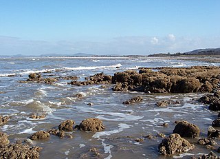
Llanddulas and Rhyd-y-foel is a community in Conwy County Borough, in Wales. It is located on the coast of Liverpool Bay, at the mouth of the Afon Dulas, 2.7 miles (4.3 km) west of Abergele, 3.6 miles (5.8 km) east of Colwyn Bay and 9.0 miles (14.5 km) east of Conwy. As the name suggests, it consists of the villages of Llanddulas and Rhyd-y-foel. At the 2001 census the community had a population of 1,572, reducing slightly to 1,542 at the 2011 census.
The Clwyd Limestone Group is a stratigraphic unit of Chadian to Brigantian age found in north Wales. It forms part of the Carboniferous Limestone Supergroup. Its most extensive outcrop is along the length of the Clwydian Range, immediately to the east of its crest, between Llandegla and Prestatyn. A further though more fragmented outcrop extends in an arc along the western margins of the Vale of Clwyd north from Rhyd-y-meudwy, west of Ruthin and then northwest to meet the coast at Llanddulas. It is prominently exposed at the Great Orme and Little Orme near Llandudno and again in three areas of eastern and southern Anglesey, together with a small area to the south of the Menai Strait between Bangor and Y Felinheli. The outcrop also extends southwards from Llandegla to form an impressive scarp at Creigiau Eglwyseg north of Llangollen and south again, to the west of Oswestry to Llanymynech Hill on the Powys/Shropshire border.

The Clwydian Range and Dee Valley is a designated Area of Outstanding Natural Beauty (AONB) and proposed national park, located in north-east Wales, covering the Clwydian Range, and the valley of the River Dee. Designated in 1985 as the Clwydian Range AONB, and expanded to its current form in 2011, the Area of Outstanding Natural Beauty includes: medieval field systems, open heather moorland, prehistoric hillforts, limestone crags, broad leaved woodland, wooded valleys, and farmland. In 2018, an estimated 1.1 million people visited six key sites across the AONB, generating approximately £24.1 million to the Welsh economy, according to Natural Resources Wales. The AONB falls within the jurisdiction of the local authorities of Denbighshire, Flintshire, and Wrexham County Borough, with the majority, 80% of the AONB in Denbighshire, and the remaining 20% split evenly between the other two authorities. The AONB is the largest of only five AONBs in Wales, and one of the 46 in the United Kingdom. Additionally, it is one of only 8 protected areas of Wales. Long-distance footpaths; Offa's Dyke Path, and the Clwydian Way pass through the AONB. The area of the Clwydian Range and Dee Valley AONB is 390 km2 (150 sq mi), and has been proposed by the Welsh Government to become Wales' fourth national park.
