
Wisconsin is a state in the upper Midwestern United States, bordered by Minnesota to the west, Iowa to the southwest, Illinois to the south, Lake Michigan to the east, Michigan to the northeast, and Lake Superior to the north. Wisconsin is the 25th-largest state by total area and the 20th-most populous.

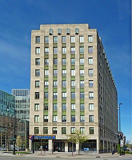
Milwaukee is the largest city in the U.S. state of Wisconsin, and the fifth-largest city in the Midwestern United States. The seat of Milwaukee County, the city is located on Lake Michigan's southwestern shore, and was incorporated in 1846. As of the 2020 census, Milwaukee had a population of 577,222, a decrease from 594,833 in 2010. It is the 31st largest city in the United States and the fourth-largest city situated along one of the Great Lakes.
Madison is the capital of the U.S. state of Wisconsin and the seat of Dane County. As of the 2020 census the population was 269,840 which made it the second-largest city in Wisconsin by population, after Milwaukee, and the 80th-largest in the United States. The city forms the core of the Madison Metropolitan Area which includes Dane County and neighboring Iowa, Green, and Columbia counties for a population of 680,796. Madison is named for American Founding Father and President James Madison. The city is located on the traditional land of the Ho-Chunk, and the Madison area is known as Dejope, meaning "four lakes", or Taychopera, meaning "land of the four lakes", in the Ho-Chunk language.

Wood County is a county located in the U.S. state of Wisconsin. As of the 2010 census, the population was 74,749. Its county seat is Wisconsin Rapids. The county is named after Joseph Wood, a member of the Wisconsin State Assembly.

Vilas County is a county in the state of Wisconsin, United States. As of the 2010 census, the population was 21,430. Its county seat is Eagle River.

Racine County is a county located in southeastern Wisconsin. As of the 2010 census, its population was 195,408, making it the fifth-most populous county in Wisconsin. Its county seat is Racine. The county was founded in 1836, then a part of the Wisconsin Territory.

Ozaukee County is a county in the U.S. state of Wisconsin. As of the 2010 census, the population was 86,395. Its county seat is Port Washington, making it one of three Wisconsin counties on Lake Michigan not to have a county seat with the same name.
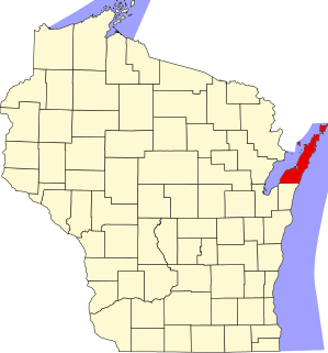
Kewaunee County is a county located in the U.S. state of Wisconsin. As of the 2010 census, the population was 20,574. Its county seat is Kewaunee. The county was created in 1852 and organized in 1859. Its Menominee name is Kewāneh, an archaic name for a species of duck.

Kenosha County is located in the southeastern corner of the U.S. state of Wisconsin. The population was 169,151 as of the 2020 census, making it the eighth most populous county in Wisconsin. The county is named after the county seat, Kenosha, the fourth largest city in Wisconsin. Kenosha County is part of the Chicago-Joliet-Naperville, IL-IN-WI Metropolitan Statistical Area. It is on the west shore of Lake Michigan.

Green Lake County is a county located in the U.S. state of Wisconsin. As of the 2010 census, the population was 19,051. Its county seat is Green Lake. In 2010, the center of population of Wisconsin was located in Green Lake County, near the city of Markesan.
Door County is the easternmost county in the U.S. state of Wisconsin. As of the 2020 census, the population was 30,066. Its county seat is Sturgeon Bay, making it one of three Wisconsin counties on Lake Michigan not to have a county seat with the same name. Instead it is named after the strait between the Door Peninsula and Washington Island. The dangerous passage, known as Death's Door, contains shipwrecks and was known to Native Americans and early French explorers.

Burnett County is a county located in the U.S. state of Wisconsin. As of the 2020 census, the population was 16,526. Its county seat is Siren, with the majority of county governmental services located at the Burnett County Government Center. The county was created in 1856 and organized in 1865.

Roxbury is a town in Dane County, Wisconsin, United States. The population was 1,700 at the 2000 census. The unincorporated communities of Alden Corners and Roxbury are located in the town. The unincorporated community of Lutheran Hill is also located partially in the town.
Hartford is a town in Washington County, Wisconsin, United States. A portion of the city of Hartford within Washington County is located adjacent to the town, but the two are politically independent. The population of the town was 4,031 at the 2000 census. The unincorporated community of Pike Lake is located in the town. The unincorporated community of Saint Lawrence is also located partially in the town.
Hartford is a city in Washington and Dodge counties in the U.S. state of Wisconsin. As of the 2010 census, the city had a population of 14,223. All of this population resided in the Washington County portion of the city. The portion of the city in Dodge County consists of only industrial/commercial parcels. Located approximately 38 miles northwest of Downtown Milwaukee and 22 miles from city limits, Hartford is located on the outer edge of the Milwaukee metropolitan area.

The Chequamegon–Nicolet National Forest is a 1,530,647-acre (6,194.31 km2) U.S. National Forest in northern Wisconsin in the United States. Due to logging in the early part of the 20th century, very little old growth forest remains. Some of the trees that grow there today were planted by the Civilian Conservation Corps in the 1930s. The national forest lands contain trees and vegetation corresponding to the North Woods Ecoregion that is prevalent throughout the upper Great Lakes region.
The Driftless Area, a region in the American Midwest, comprises southwestern Wisconsin, southeastern Minnesota, northeastern Iowa, and the extreme northwestern corner of Illinois. It was never covered by ice during the last ice age, and therefore lacks glacial deposits, also termed drift. Its landscape is characterized by steep hills, forested ridges, deeply carved river valleys, and karst geology with spring-fed waterfalls and cold-water trout streams. Ecologically, the Driftless Area's flora and fauna are more closely related to those of the Great Lakes region and New England than those of the broader Midwest and central Plains regions. The steep riverine landscape of both the Driftless Area proper and the surrounding Driftless-like region are the result of early glacial advances that forced preglacial rivers that flowed into the Great Lakes southward, causing them to carve a gorge across bedrock cuestas, thereby forming the modern incised upper Mississippi River valley. The region has elevations ranging from 603 to 1,719 feet at Blue Mound State Park, and together with the Driftless-like region, covers 24,000 square miles (62,200 km2).

Lake Mendota is a freshwater eutrophic lake that is the northernmost and largest of the four lakes in Madison, Wisconsin. The lake borders Madison on the north, east, and south, Middleton on the west, Shorewood Hills on the southwest, Maple Bluff on the northeast, and Westport on the northwest. Lake Mendota acquired its present name in 1849 following a proposal by a surveyor named Frank Hudson, who claimed to be familiar with local Native American languages; Lyman C. Draper, the first corresponding secretary of the Wisconsin Historical Society, proposed that 'Mendota' could have been a Chippewa word meaning 'large' or 'great.'

The Lac Courte Oreilles Tribe is one of six federally recognized bands of Ojibwe people located in present-day Wisconsin. The band is based at the Lac Courte Oreilles Indian Reservation, at 45°52′59″N91°19′13″W in northwestern Wisconsin, which surrounds Lac Courte Oreilles. The main reservation's land is in west-central Sawyer County, but two small plots of off-reservation trust land are located in Rusk, Burnett, and Washburn counties. The Reservation was established in 1854 by the second Treaty of La Pointe.

Chambers Island, named in honor of Col. Talbot Chambers, is a 2,834 acre island in Green Bay, about 7 miles (11 km) off the coast of the Door Peninsula, near Gibraltar, Wisconsin. It is part of the Town of Gibraltar in Door County.

