Related Research Articles
Crane Creek is a 23.2-mile-long (37.3 km) stream that flows pst the town of Crane. The creek, a tributary of the James River and part of the White River drainage basin, is a part of the Missouri Department of Conservation's trout management program and is classified as a Blue Ribbon Trout Area.
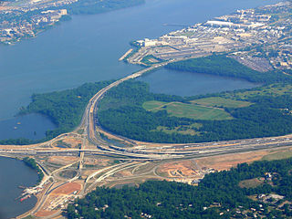
Oxon Creek is a stream on the Potomac River which feeds a cove that straddles the border between Washington, D.C. and Prince George's County, Maryland just north of Interstate 495 at Woodrow Wilson Bridge. Oxon Creek heads at the confluence of Oxon Run and Barnaby Run, sometimes referred to as Winkle Doodle Run. It starts just inside the boundary of D.C. and then runs 1.5 miles (2.4 km) to the south and west into Maryland to empty into the Potomac at Goose Island across from the city of Alexandria, Virginia. Before reaching the Potomac, the creek widens to form Oxon Cove which is partially in Maryland and partially in Washington, D.C.. The creek is almost entirely within Oxon Cove National Park, except for the first few feet in D.C. and a portion of the cove on the southside of the Blue Plains Advanced Wastewater Treatment Plant.
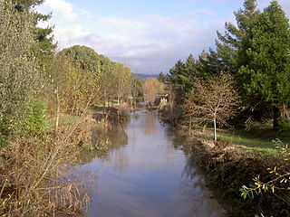
Hinebaugh Creek is a westward-flowing stream in western Sonoma County within the Laguna de Santa Rosa watershed. As this watercourse proceeds westerly through the city of Rohnert Park, it has largely been channelized and courses in an artificially straight alignment. Considered waters of the United States as a jurisdictional matter, Hinebaugh Creek is potential habitat for the California red-legged frog and the Western pond turtle. The dominant riparian vegetation is Himalayan blackberry and willow.
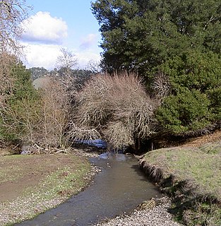
Crane Creek is a stream in Sonoma County, California, United States which rises in the northern Sonoma Mountains. This watercourse flows through Crane Canyon and the Crane Creek Regional Park situated on the northwestern flank of Sonoma Mountain. Crane Creek forms a confluence with Hinebaugh Creek in the city of Rohnert Park; thereafter, the channelized Hinebaugh Creek flows westerly to discharge to the Laguna de Santa Rosa. Hiking access to the upper Crane Creek reaches is from Roberts Road off Petaluma Hill Road.

Crane Creek Township is one of twenty-five townships in Barry County, Missouri, United States. As of the 2000 census, its population was 923.
Crane Pond Creek is a stream in Iron and Wayne counties in the U.S. state of Missouri.
Oto is an unincorporated community in Stone County, in the U.S. state of Missouri. The community is located on Crane Creek, approximately four miles north of Galena. Missouri Route AA passes through the community along Oto Ridge to the north of the Crane Creek crossing.
Mill Creek is a stream in southwestern Madison County and the northwest corner of Wayne County in the U.S. state of Missouri. It is a tributary of Crane Pond Creek.

The Canajoharie Creek is a river that flows into the Mohawk River in the Village of Canajoharie in the U.S. State of New York. The name "Canajoharie" is a Mohawk language term meaning "the pot that washes itself", referring to the "Canajoharie Boiling Pot", a 20-foot (6.1 m) wide and 10-foot (3.0 m) deep pothole in the Canajoharie Creek, just south of the village of Canajoharie. Bowmans Creek is one main tributary that enters the creek east of the Hamlet of Sprout Brook. The other main tributary is Brimstone Creek which enters the creek north-northwest of the Village of Ames.
The Nowadaga Creek basin drains portions of the towns of Danube, Stark, and Little Falls, as well as a small portion of the town of Warren, in southern Herkimer County before converging with the Mohawk River in Indian Castle, New York. The drainage basin is approximately 49 percent forested. The creek has an average slope of 1.7 percent over its entire stream length of 10.0 miles. On a 1790 land patent map it is spelled "Inchanando Creek".
Moyer Creek starts at Wheelock Pond near Jerusalem Hill, New York. Past Gulph, New York Moyer Creek follows a deep ravine, the Frankfort Gorge, south towards Frankfort, New York before converging with the Mohawk River in Frankfort, New York. The headwaters of Moyer Creek rise within a half mile of the source of the Unadilla River which is the most northerly headwater source of the Susquehanna and the closest to the Mohawk River.

Caroga Creek is a river in Fulton County in the U.S. State of New York. It begins at East Caroga Lake and flows south passing through Rockwood Lake before converging with the Mohawk River in the Hamlet of Palatine Church.
Cayadutta Creek flows into the Mohawk River near Fonda, New York. The Indian meaning of Cayadutta is "rippling waters" or "shallow water running over stones". This stream has commercial and historical importance as the cities of Johnstown and Gloversville lie on its banks.
Cobleskill Creek starts at Pine Mountain west of West Richmondville and flows east-northeast before converging with Schoharie Creek in Central Bridge, New York. The creek flows through the village of Richmondville, New York and Cobleskill, New York.
Panther Mountain is a mountain located in Central New York of New York near Fly Creek, New York and Schuyler Lake, New York. The east side of Panther Mountain drains into Fly Creek and the west side drains into Oaks Creek and Canadarago Lake.

Badeau Hill is a mountain located in Central New York region of New York northwest of Elk Creek, New York.
Gifford Hill is a small mountain chain in the Central New York Region of New York. It is located northeast of Oneonta, New York. It is made of three main peaks the highest being 1928 feet. Gifford Hill is named for the Gifford Family who moved to the area in 1803 and settled along the Oneonta Creek on what is now called Gifford Hill.

The Raft River is a stream located entirely within the Quinault Indian Reservation in Grays Harbor County, on the Olympic Peninsula, in the U.S. state of Washington. The river and its tributaries flow west from the Olympic Mountains and empty into the Pacific Ocean. It is situated a few miles north of the Quinault River and a few miles south of the Queets River.

Crane Creek is a 23.41 mi (37.67 km) long 4th order tributary to the Little River in Moore County, North Carolina.
References
- ↑ "Crane creek". Geographic Names Information System . United States Geological Survey . Retrieved 2017-10-13.
- ↑ "crane creek". usgs.gov. usgs. 1995. Retrieved 18 April 2017.
data
| This article related to a river in New York is a stub. You can help Wikipedia by expanding it. |