
Crawford Place is a street in the Marylebone district of the City of Westminster, London. The street was developed in the first decade of the 1800s and was original known as John Street West.
Crawford Place is a street in the Marylebone district of the City of Westminster, London. The street was developed in the first decade of the 1800s and was original known as John Street West.

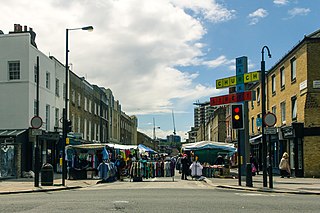
The street runs from Edgware Road in the west to the junction of Homer Row, Shouldham Street, and Crawford Street in the east. Brendon Street, Cato Street, and Molyneux Street run south from Crawford Place. Watson's Mews is off the north side of Crawford Place.

The street and the adjacent streets to the east of Edgware Road were laid out in the first decade of the 1800s as an area of "fourth rate" terraced housing. Greenwood's map of 1830 shows it marked as John Street West. [1] It is now known as Crawford Place and there are several streets in the area named after Tarrant Crawford, a property in Dorset owned by the Portman family who owned much of the land in Marylebone. [2]
The street is mostly within the City of Westminster's Molyneux Street Conservation Area. [3]
On the north side of the street, Abrar House, on the corner with Homer Row, is the home on the second floor of the High Commission for Antigua & Barbuda in London. [4] The third floor of Abrar House is the High Commission of Belize in London. [5] Also on the north side are, from east to west, the rear of the Roman Catholic Church of Our Lady of the Rosary, Marylebone, the Windsor Castle public house, The Christian Union Alms-Houses (rebuilt 1899), [6] and the Crawford Place mansion block at No. 11. [3]
On the south side of the street are The Larrick public house on the corner with Shouldham Street, the modernist Elliott House (1939) between Molyneux Street and Cato Street, the Lord Wargrave public house on the corner with Brendon Street, and the Central London Seventh-Day Adventist Church at the eastern end of the street. [7]
The Windsor Castle and The Larrick public houses are not listed buildings with Historic England but are designated buildings of merit within the Molyneux Street conservation area. [1]
The remainder of the street is a mix of terraced houses, small shops and modern buildings.

The West End of London is a district of Central London, London, England, west of the City of London and north of the River Thames, in which many of the city's major tourist attractions, shops, businesses, government buildings and entertainment venues, including West End theatres, are concentrated.

Paddington is an area in the City of Westminster, in central London, England. A medieval parish then a metropolitan borough of the County of London, it was integrated with Westminster and Greater London in 1965. Paddington station, designed by the engineer Isambard Kingdom Brunel opened in 1847. It is also the site of St Mary's Hospital and the former Paddington Green Police Station.

Marylebone Road is an important thoroughfare in central London, within the City of Westminster. It runs east–west from the Euston Road at Regent's Park to the A40 Westway at Paddington. The road which runs in three lanes in both directions, is part of the London Inner Ring Road and as such forms part of the boundary of the zone within which the London congestion charge applies.

The Marble Arch is a 19th-century white marble-faced triumphal arch in London, England. The structure was designed by John Nash in 1827 as the state entrance to the cour d'honneur of Buckingham Palace; it stood near the site of what is today the three-bayed, central projection of the palace containing the well-known balcony. In 1851, on the initiative of architect and urban planner Decimus Burton, a one-time pupil of John Nash, the arch was relocated to its current site, near the northeast corner of Hyde Park, so that expansion of Buckingham Palace could proceed.

The Metropolitan Borough of St Marylebone was a metropolitan borough of the County of London from 1900 to 1965. It was based directly on the previously existing civil parish of St Marylebone, Middlesex, which was incorporated into the Metropolitan Board of Works area in 1855, retaining a parish vestry, and then became part of the County of London in 1889.
Lisson Grove is a street and district in the City of Westminster, West London. The West End neighbourhood contains a few important cultural landmarks, including Lisson Gallery, Alfies Antique Market, Red Bus Recording Studios, the former Christ Church, now the Greenhouse Centre, Stringers of London and the Seashell of Lisson Grove.

Great Titchfield Street is a street in the West End of London. It runs north from Oxford Street to Greenwell Street, just short of the busy A501 Marylebone Road and Euston Road. It lies within the informally designated London area of Fitzrovia. In administrative terms it is in the City of Westminster. It lies within their designated East Marylebone Conservation Area in the former Metropolitan Borough of St Marylebone.
Marylebone is an area in London, England and is located in the City of Westminster. It is in Central London and part of the West End. Oxford Street forms its southern boundary.

Thayer Street is a street in the Marylebone district of the City of Westminster, London, that contains four listed buildings.

Crawford Street is a street in the Marylebone district of the City of Westminster, London. The street contains two grade II listed public houses.

Homer Row is a street in the Marylebone district of the City of Westminster, London, that runs form Old Marylebone Road in the north to the junction of Crawford Place and Crawford Street in the south.

Homer Street is a quiet one-way street in the Marylebone neighbourhood of the City of Westminster, London. It runs from Old Marylebone Road in the north to Crawford Street in the south. The street is part of the Marylebone Ward of Westminster City Council. Its postcode is W1H.
John Simon Harcourt of Ankerwycke, Buckinghamshire, was member of Parliament for Westbury 18 April 1800 - 1802.

Marylebone Lane is one of the original streets of the Marylebone district of the City of Westminster, London. It runs from Oxford Street in the south to Marylebone High Street in the north, its winding shape following the course of the River Tyburn that it once ran alongside and pre-dating the grid pattern of the other streets in the area. Today the lane is largely composed of small shops, cafes and restaurants with some small apartment blocks. There are some larger commercial buildings at the southern end near Oxford Street.
This is a list of the etymology of street names in the London district of Marylebone. The following utilises the generally accepted boundaries of Marylebone viz. Marylebone Road to the north, Great Portland Street to the east, Marble Arch and Oxford Street to the south and Edgware Road to the west.

Seymour Place is a street in Marylebone in Central London. Located in the City of Westminster, it runs north from Seymour Street until it meets Marylebone Road, where it becomes Lisson Grove. It is crossed by Crawford Street, George Street, and York Street and runs parallel to Gloucester Place, which lies to its east. Its southern end is about 180 metres northwest of Marble Arch and about 40 metres east of Edgware Road.
Church Street Market is a large outdoor street market on Church Street in the Marylebone area of the City of Westminster. It takes place on Strutton Ground. Licences to trade are issued by Westminster City Council.

George Street is a street in Marylebone in Central London, England. Located in the City of Westminster, it runs east from Edgware Road until it reaches Marylebone High Street at its junction with Thayer Street. It crosses a number of streets including Seymour Place, Gloucester Place, Manchester Street and Baker Street.

Connaught Street is a street in Central London. Located in the City of Westminster, it is part of the Tyburnia area of Paddington north of Hyde Park. It runs west to east from Hyde Park Square to the Edgware Road. It continues eastwards becoming Upper Berkeley Street in Marylebone. The street contains a mixture of commercial and residential properties, forming part of Connaught Village. Connaught Square and Albion Street are located on its southern side. The Duke of Kendal public house sits at the junction between Connaught Street and Kendal Street.
![]() Media related to Crawford Place, London at Wikimedia Commons 51°31′06″N0°09′56″W / 51.5183°N 0.1656°W
Media related to Crawford Place, London at Wikimedia Commons 51°31′06″N0°09′56″W / 51.5183°N 0.1656°W