
A tumulus is a mound of earth and stones raised over a grave or graves. Tumuli are also known as barrows, burial mounds or kurgans, and may be found throughout much of the world. A cairn, which is a mound of stones built for various purposes, may also originally have been a tumulus.

The Weardale Railway is an independently-owned British single-track branch line heritage railway between Bishop Auckland, Witton-le-Wear, Wolsingham, Frosterley and Stanhope. Weardale Railway began services on 23 May 2010, but decided to run special trains rather than a scheduled service for the 2013 season. The line was purchased by the Auckland Project in 2020 with a view to restarting passenger services. In 2021, a bid was submitted to the Restoring Your Railways fund. In October 2021, the Department for Transport allocated funding for the development of a business case.
Wolsingham is a market town in Weardale, County Durham, England. It is situated by the River Wear, between Crook and Stanhope.
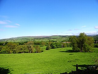
Weardale is a dale, or valley, on the east side of the Pennines in County Durham, England. Large parts of Weardale fall within the North Pennines Area of Outstanding Natural Beauty (AONB) – the second-largest AONB in England and Wales. The upper dale is surrounded by high fells and heather grouse moors. The River Wear flows through Weardale before reaching Bishop Auckland and then Durham, meeting the sea at Sunderland.

Dunkery Beacon at the summit of Dunkery Hill is the highest point on Exmoor and in Somerset, England. It is also the highest point in southern England outside of Dartmoor.

Crawleyside is a village in County Durham, in England. It is situated to the north of Stanhope, in Weardale. In the 2001 census Crawleyside had a population of 170.

Frosterley is a village in County Durham, in England. It is situated in Weardale, on the River Wear close to its confluence with Bollihope Burn; between Wolsingham and Stanhope; 18 miles west of Durham City and 26 miles southwest of Newcastle-upon-Tyne. In the 2001 census Frosterley had a population of 705.

Stanhope is a market town and civil parish in the County Durham district, in the ceremonial county of Durham, England. It lies on the River Wear between Eastgate and Frosterley, in the north-east of Weardale. The main A689 road over the Pennines is crossed by the B6278 between Barnard Castle and Shotley Bridge. In 2001 Stanhope had a population of 1,633, in 2019 an estimate of 1,627, and a figure of 1,602 in the 2011 census for the ONS built-up-area which includes Crawleyside. In 2011 the parish population was 4,581.

Westgate is a village in County Durham, in North East England. It is situated in Weardale between St John's Chapel and Eastgate. In the 2001 census Westgate had a population of 298. Westgate is also the entrance to Slitt wood and an old abandoned lead mine. Other features of the village include a caravan site and a football and basketball court.

Bishop Auckland is a railway station that serves the market town of Bishop Auckland in County Durham, North East England, 11 miles 77 chains (19.3 km) north-west of Darlington. The station is the Western terminus of the Tees Valley Line, which links it to Saltburn via Darlington. It is owned by Network Rail and managed by Northern Trains.

Philip James Stanhope, 1st Baron Weardale, was a British Liberal Party politician and philanthropist.

The River Wear in Northern England rises in the Pennines and flows eastwards, mostly through County Durham, to the North Sea in the City of Sunderland. At 60 mi (97 km) long, it is one of the region's longest rivers. The Wear wends in a steep valley through the cathedral city of Durham and gives its name to Weardale in its upper reach and Wearside by its mouth.
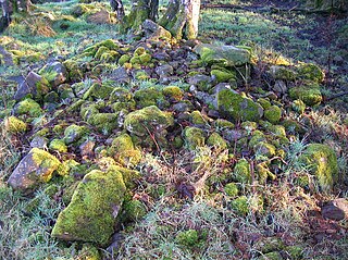
A clearance cairn is an irregular and unstructured collection of fieldstones which have been removed from arable land or pasture to allow for more effective agriculture and collected into a usually low mound or cairn. Commonly of Bronze Age origins, these cairns may be part of a cairnfield where some cairns might be funerary. Clearance cairns are a worldwide phenomenon wherever organised agriculture has been practised.
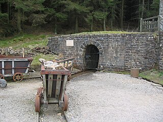
The North of England Lead Mining Museum, better known as Killhope, is an industrial museum near the village of Cowshill, County Durham, England. The museum stands on the site of the former Park Level Mine, which is being restored to show the workings of a 19th-century lead mine.

There are over 670 scheduled monuments in the ceremonial county of Somerset in South West England. The county consists of a non-metropolitan county, administered by Somerset Council. The two administratively independent unitary authorities, which were established on 1 April 1996 following the breakup of the county of Avon, are North Somerset and Bath and North East Somerset. These unitary authorities include areas that were once part of Somerset before the creation of Avon in 1974.

Heathery Burn Cave is a cave near Stanhope, County Durham, England, in which a large collection of Late Bronze Age weapons and tools was discovered and excavated between 1859 and 1872.
Cecily Margaret Guido,, also known as Peggy Piggott, was an English archaeologist, prehistorian, and finds specialist. Her career in British archaeology spanned sixty years, and she is recognised for her field methods, her field-leading research into prehistoric settlements, burial traditions, and artefact studies, as well as her high-quality and rapid publication, contributing more than 50 articles and books to her field between the 1930s and 1990s.

Eastgate railway station, also known as Eastgate-in-Weardale, served the village of Eastgate in County Durham, North East England from 1895 to 1953 as a stop on the Wear Valley Line.

Witton-le-Wear railway station is a railway station on the Weardale heritage railway serves the village of Witton-le-Wear in County Durham, North East England, and is the penultimate stop for most of line's eastbound passenger services. The current station platform is located on the opposite side of the track to the original railway station which was operation between 1847 and 1953.
The Kirkhaugh cairns are two, or possibly three, Bronze Age burials located in Kirkhaugh, Northumberland. The two confirmed graves were excavated in 1935 and re-excavated in 2014. The first grave, dubbed Cairn 1, contained grave goods consistent with a high-status metalworker. These included two of the earliest gold ornaments, and one of the earliest bell beakers, known in Britain. The second grave was empty.
