Creu de Santos

Last updated
Creu de Santos
Xàquera
Creu de Santos.JPG
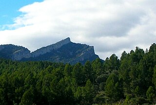
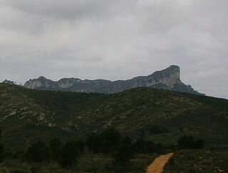
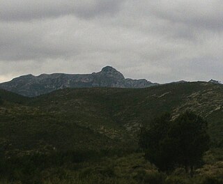
View of the Creu de Santos (or Xàquera) summit
Highest point
Elevation 941 m (3,087 ft)
Listing Mountains in Catalonia
Coordinates 40°56′25.88″N0°35′9.77″E / 40.9405222°N 0.5860472°E / 40.9405222; 0.5860472 Coordinates: 40°56′25.88″N0°35′9.77″E / 40.9405222°N 0.5860472°E / 40.9405222; 0.5860472
Geography
Tarragona-loc.svg
Red triangle with thick white border.svg
Creu de Santos
Location
Catalonia location map.svg
Red triangle with thick white border.svg
Creu de Santos
Creu de Santos (Catalonia)
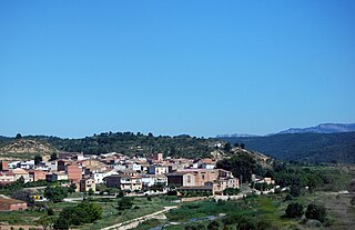
Location Tivenys, Benifallet, and Rasquera,
Catalonia, Spain
Parent range Serra de Cardó
Climbing
Easiest route Walk

Creu de Santos or Xàquera is the highest mountain of the Serra de Cardó range, Catalonia, Spain. The Serra de Cardó is part of the Massís de Cardó, Catalan Pre-Coastal Range. This mountain has an elevation of 941 metres above sea level. [1]

Catalonia Autonomous area of northeastern Spain

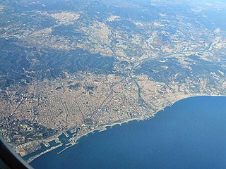
Catalonia is an autonomous community in Spain on the northeastern corner of the Iberian Peninsula, designated as a nationality by its Statute of Autonomy. Catalonia consists of four provinces: Barcelona, Girona, Lleida, and Tarragona. The capital and largest city is Barcelona, the second-most populated municipality in Spain and the core of the sixth most populous urban area in the European Union. It comprises most of the territory of the former Principality of Catalonia. It is bordered by France (Occitanie) and Andorra to the north, the Mediterranean Sea to the east, and the Spanish autonomous communities of Aragon to the west and Valencia to the south. The official languages are Catalan, Spanish, and the Aranese dialect of Occitan.

Spain Kingdom in Southwest Europe

Spain, officially the Kingdom of Spain, is a country mostly located in Europe. Its continental European territory is situated on the Iberian Peninsula. Its territory also includes two archipelagoes: the Canary Islands off the coast of Africa, and the Balearic Islands in the Mediterranean Sea. The African enclaves of Ceuta, Melilla, and Peñón de Vélez de la Gomera make Spain the only European country to have a physical border with an African country (Morocco). Several small islands in the Alboran Sea are also part of Spanish territory. The country's mainland is bordered to the south and east by the Mediterranean Sea except for a small land boundary with Gibraltar; to the north and northeast by France, Andorra, and the Bay of Biscay; and to the west and northwest by Portugal and the Atlantic Ocean.

Catalan Pre-Coastal Range system of mountain ranges running parallel to the Mediterranean Sea coast in Catalonia

The Catalan Pre-Coastal Range is a system of mountain ranges running parallel to the Mediterranean Sea coast in Catalonia. It is part of the Catalan Mediterranean System. Its main axis runs between the Catalan Transversal Range and the Serra de l'Espina, which connects with the Ports de Tortosa-Beseit, part of the Iberian System. The highest point is 1.706,7 m at the Montseny Massif.

See also

Related Research Articles

Province of Barcelona Province of Spain

Barcelona is a province of eastern Spain, in the center of the autonomous community of Catalonia. The province is bordered by the provinces of Tarragona, Lleida, and Girona, and by the Mediterranean Sea. Its area is 7,726 km2 (2,983 sq mi). 5,609,350 people live in the province, of whom about 30% (1,620,343) live within the administrative limits of the city of Barcelona, which itself is contained in the Barcelona metropolitan area.

La Miranda mountain in Spain

La Miranda is a mountain of the Catalan Pre-Coastal Range in the autonomous community of Catalonia in Spain. It has an elevation of 918 metres above sea level.

Tossal Gros de Miramar, or simply Tossal Gros, is a mountain of the Catalan Pre-Coastal Range, Catalonia, Spain. It has an elevation of 866.6 metres above sea level.

Tossal Gros de Vallbona is a mountain of the Catalan Central Depression, Catalonia, Spain. It has an elevation of 802 metres above sea level.

Serra de Montsant mountain range

Serra de Montsant is a mountain chain in Catalonia, Spain. The main populated area in the range is La Morera de Montsant.

Serra de lEspina mountain in Spain

Serra de l'Espina is a limestone mountain chain located at the north-eastern end of the Iberian System. It connects the Ports de Tortosa-Beseit mountain massif with the Catalan Pre-Coastal Range.

Serra de Pàndols mountain in Spain

Serra de Pàndols is a limestone mountain chain located at the southern end of the Catalan Pre-Coastal Range, in Catalonia, Spain.

Serra de Cavalls mountain in Spain

Serra de Cavalls is a mountain chain located at the southern end of the Catalan Pre-Coastal Range, Catalonia, Spain. The ridge's highest point is Punta Redona. This mountain range lies within the Benissanet, Gandesa and El Pinell de Brai municipal term. On the northern side are two ridges of parallel foothills called Serra del Pebre and Serra de Santa Madrona. Its northern prolongation is known as Serra de la Vall de la Torre.

Serra dels Pesells mountain in Spain

Serra dels Pesells is a mountain chain located near the southern end of the Catalan Pre-Coastal Range between Bot and Arenys de Lledó. The ridge's highest point is 541,3 m. This smooth range runs in a NNE - SSW direction and divides the basins of the Canaletes and Algars rivers. It is one of the isolated hills of the Catalan Central Depression and it is located at its southwestern end.

Serra de Paüls mountain in Spain

Serra de Paüls is a mountain range in the northern side of the Ports de Tortosa-Beseit, Catalonia, Spain. The highest summit, Punta de l'Aigua has an elevation of 1,091.6 metres above sea level.

Catalan Central Depression

The Catalan Central Depression is a natural depression between the Pre-Pyrenees and the Catalan Pre-Coastal Range in Spain. It widens towards the west, linking with the Ebro Depression, Catalan: Depressió de l'Ebre, of which it could be considered an eastern extension. The Catalan Central Depression is about 180 km long with an average width of 50 km.

Serra de la Llena mountain in Spain

Serra de la Llena, also known as Serra la Llena, is a mountain chain straddling the municipal terms of Vilanova de Prades, La Pobla de Cérvoles (Garrigues) and Ulldemolins (Priorat), in Catalonia, Spain. These mountains have characteristic large and rounded rocky outcrops.

Cardó Massif

The Cardó Massif, also known as Cardó-Boix Massif, is a mountain massif in the Baix Ebre comarca, in Catalonia, Spain. This massif is composed of a number of mountain ranges located on the left side of the Ebro river near Tortosa. The massive calcareous cliffs of the Serra de Cardó form the eastern side of the spectacular gorges through which the Ebro River winds its way in the final stage of its course, separating the Ebro Valley from the Mediterranean coastal area.

Morral de Cabrafeixet mountain in Spain

Morral de Cabrafeixet is one of the highest mountains of the Cardó Massif, Catalan Pre-Coastal Range, Catalonia, Spain. Its NW side has an impressive escarpment visible from Highway N-340 approaching El Perelló from the north. This mountain has an elevation of 753 metres above sea level.

Buinaca mountain in Spain

Buinaca or Punta de la Buinaca, also spelt Boinaca, is one of the highest mountains of the Cardó Massif, Catalan Pre-Coastal Range, Catalonia, Spain. This mountain has an elevation of 764 metres above sea level.

Serra de Llaberia mountain in Spain

Serra de Llaberia is a mountain chain in Catalonia, Spain located between the Prades and the Tivissa-Vandellòs Mountains.

Serra de la Fatarella mountain in Spain

Serra de la Fatarella is one of the isolated mountain ranges of the Catalan Central Depression located off the southern end of the Catalan Pre-Coastal Range between La Fatarella and Ascó in Spain. The ridge's highest point is 563.5 m; another important summit is 552 m high Punta de l'Home. This smooth range runs in a N - S direction.

Mola de Colldejou mountain in Spain

Mola de Colldejou is a mountain chain in Catalonia, Spain located north of the Serra de Llaberia in the Catalan Pre-Coastal Range. The highest point is 921.8 m above sea level.

Serra de la Vall de la Torre

Serra de la Vall de la Torre, also known as Serra de la Vall, is a mountain range located at the southern end of the Catalan Pre-Coastal Range, Catalonia, Spain. The ridge's highest point is 450.8 m. This mountain range lies within the Benissanet and Corbera d'Ebre municipal term. It is a smaller and lower northern prolongation of the Serra de Cavalls.

References

  1. "Mapa Topogràfic de Catalunya". Institut Cartogràfic de Catalunya. Retrieved May 22, 2010..