Herm is one of the Channel Islands and part of the Parish of St Peter Port in the Bailiwick of Guernsey. It is located in the English Channel, north-west of France and south of England. It is 2,183 m (7,162 ft) long and under 873 metres (2,864 ft) wide; oriented north–south, with several stretches of sand along its northern coast. The much larger island of Guernsey lies to the west, Jersey lies to the south-east, and the smaller island of Jethou is just off the south-west coast.
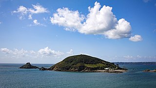
Jethou is a small island that is part of the Bailiwick of Guernsey in the Channel Islands. It is privately leased from the Crown, and not open to the public. Resembling the top of a wooded knoll, it is immediately south of Herm and covers approximately 44 acres (18 ha).
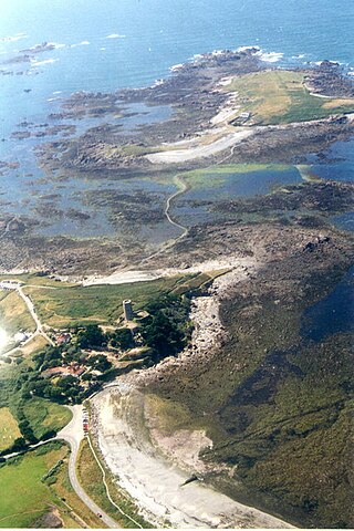
Lihou is a small tidal island located just off the west coast of the island of Guernsey, in the English Channel, between Great Britain and France. Administratively, Lihou forms part of the Parish of St. Peter's in the Bailiwick of Guernsey, and is now owned by the parliament of Guernsey, although there have been a number of owners in the past. Since 2006, the island has been jointly managed by the Guernsey Environment Department and the Lihou Charitable Trust. In the past the island was used by locals for the collection of seaweed for use as a fertiliser, but today Lihou is mainly used for tourism, including school trips. Lihou is also an important centre for conservation, forming part of a Ramsar wetland site for the preservation of rare birds and plants as well as historic ruins of a priory and a farmhouse.

Burhou is a small island about 1.4 miles (2.3 km) northwest of Alderney that is part of the Channel Islands. It has no permanent residents, and is a bird sanctuary, so landing there is banned from March 15 to August 1. The island's wildlife includes a colony of puffins and many rabbits.
The Bailiwick of Guernsey is a self-governing British Crown Dependency off the coast of Normandy, France, comprising several of the Channel Islands. It has a total land area of 78 square kilometres (30 sq mi) and an estimated total population of 67,334.

St. Peter Port is a town and one of the ten parishes on the island of Guernsey in the Channel Islands. It is the capital of the Bailiwick of Guernsey as well as the main port. The population in 2019 was 18,958.

A volcanic plug, also called a volcanic neck or lava neck, is a volcanic object created when magma hardens within a vent on an active volcano. When present, a plug can cause an extreme build-up of high gas pressure if rising volatile-charged magma is trapped beneath it, and this can sometimes lead to an explosive eruption. In a plinian eruption the plug is destroyed and ash is ejected.

Ortac is a small uninhabited islet about 5 kilometres west of the coast of Alderney near to the islet of Burhou. It measures roughly 50 by 70 metres, and rises 24 metres above the sea level.

Saint Anne is the main town of Alderney in the Channel Islands.

St Sampson is a parish of Guernsey, an island in the Bailiwick of Guernsey, directly north of St Peter Port. It is on the north-west and north-east coasts of the island and is split into two sections, intersected by Vale.

Castle Cornet is a large island castle in Guernsey, and former tidal island, also known as Cornet Rock or Castle Rock. Its importance was as a defence not only of the island, but of the roadstead. In 1859 it became part of one of the breakwaters of Guernsey's main harbour, St Peter Port harbour.

The Écréhous are a group of islands and rocks situated six miles (9.6 km) north-east of Jersey, and eight miles (12.8 km) from France. They form part of the Bailiwick of Jersey and are administratively part of the Parish of St Martin.
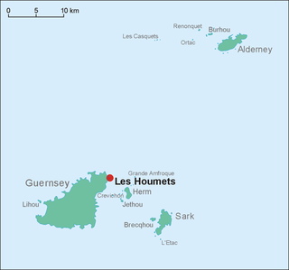
Les Houmets are to the east of Guernsey in the Channel Islands. Their name derives from a diminutive of hou, a Norman/Guernésiais word meaning islets. They are tidal islands.

Little Sark is a peninsula forming the southern section of the Channel Island of Sark. There is a hamlet here, and also a hotel and cafe at La Sablonnerie.
The following outline is provided as an overview of and topical guide to Guernsey:

This is a list of books in the English language which deal with Guernsey and its geography, history, inhabitants, culture, biota, etc.

The Bréhon Tower is accessible only by boat and sits on Bréhon Rock, an island in the Little Russell channel about 1.5 km northeast of St Peter Port, Guernsey, between the port and the islands of Herm and Jethou. Thomas Charles de Putron (1806–1869) built the oval tower of granite from Herm, completing the work in 1857.
Ernest David Marquand (1848–1918) was an English botanist, perhaps best known as the author of Flora of Guernsey. His son was the noted botanist Cecil Victor Boley Marquand.
The Braye du Valle is the area between the main Island of Guernsey and Le Clos du Valle, which was a tidal island to the north.

Archaeology is promoted in Jersey by the Société Jersiaise and by Jersey Heritage. Promotion in the Bailiwick of Guernsey being undertaken by La Société Guernesiaise, Guernsey Museums, the Alderney Society with World War II work also undertaken by Festung Guernsey.


