
Slatina is a town in the Slavonia region of Croatia. It is located in the Virovitica-Podravina County, at the contact of the Drava valley and the foothills of Papuk mountain, in the central part of the region of Podravina, 29 km (18 mi) southeast of Virovitica; elevation 127 metres. It was ruled by Ottoman Empire between 1542 and 1687, when it was captured by Austrian troops. During Ottoman rule it was initially part of Sanjak of Pojega between 1542 and 1601, latterly part of Sanjak of Rahoviçe between 1601 and 1687. It was district centre at Virovitica County in Kingdom of Croatia-Slavonia between 1868 and 1918.

Novi Marof is a town in north-western Croatia, located south of Varaždin and east of Ivanec, in Varaždin County. It lies on the intersection of state roads D3 and D24 and is also connected with highway A4, state road D22 and R201 railway.

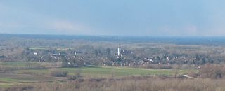
Kaptol is a village and a municipality in central Slavonia, Croatia. It is located on the slopes of Papuk mountain, east of Velika and northeast of Požega.

Brezovica is a city district and a settlement part of Zagreb, Croatia, located in the southwestern part of the city.
Legrad is a municipality in northern Croatia, located north of Koprivnica and east of Ludbreg in the Koprivnica–Križevci County. There are 2,241 inhabitants in the municipality, absolute majority of which are Croats at 97.4%, with the largest minority being Romani at 1% of the municipality. Beside the Roman Catholic majority, there are Hungarian and Croatian Lutherans that have a tradition beginning in the 16th century.

Klanjec is a small town in northwestern Croatia, in the region of Hrvatsko Zagorje on the border with Slovenia.
Čaglin is a village and a municipality in Slavonia, Croatia. The population of the municipality was 2122 in 2021.

Babina Greda is a village and a municipality in Vukovar-Syrmia County in eastern Croatia. The 2011 census listed 3,572 inhabitants in Babina Greda. With pronounced issue of population decline in eastern Croatia caused by population ageing, effects of the Croatian War of Independence and post 2013 enlargement of the European Union emigration, the population of the municipality at the time of 2021 census dropped to 2,762.
Špišić Bukovica is a municipality in Croatia in the Virovitica–Podravina County.
Oprisavci is a village and municipality in Brod-Posavina County, Croatia.
Barilović is a village and a municipality in central Croatia, in the Karlovac County.

Generalski Stol is a village and a municipality in Karlovac County, Croatia.
Sveti Ivan Žabno is a municipality in the Koprivnica-Križevci County in Croatia. According to the 2011 census, there are 5,222 inhabitants in the area.
Novi Golubovec is a village and municipality in Krapina-Zagorje County in northern Croatia. According to the 2011 census, there are 996 inhabitants in the area, in the following settlements:

Novi Bezdan is a settlement in the region of Baranja, Croatia. Administratively, it is located in the Petlovac municipality within the Osijek-Baranja County. Population is 300 people.
Brest Pokupski is a village in Banovina region of Croatia. The settlement is administratively located in the Town of Petrinja and the Sisak-Moslavina County. According to the 2011 census it has 279 inhabitants. It is connected by the D30 state road. The village was damaged to a notable extent in the 2020 Petrinja earthquake and the subsequent shaking. Some of the damage was caused by soil liquefaction, a rare phenomenon observed for the first time in Croatia since the 1880 Zagreb earthquake.
Novi Mihaljevci is a village in Požega-Slavonia County, Croatia. The village is administered as a part of the City of Požega.
Grižane-Belgrad is a village in Primorje-Gorski Kotar County of Croatia. It is located near Crikvenica and Novi Vinodolski. It has a population of 953 and the post code HR-51244.
Veliko Polje is an urban settlement of the Croatian capital of Zagreb, within Novi Zagreb – istok District.
Bandino Selo is a village in Croatia, under the Slunj township, in Karlovac County. It is located 92km away from the national capital, Zagreb. Until the territorial reorganization in Croatia, Bandino Selo was part of the old municipality of Slunj. As an independent settlement, Bandino Selo has existed since the 2001 census. It was created by separating a part of the settlement of Crno Vrelo.
