
Kruger National Park is a South African National Park and one of the largest game reserves in Africa. It covers an area of 19,623 km2 (7,576 sq mi) in the provinces of Limpopo and Mpumalanga in northeastern South Africa, and extends 360 km (220 mi) from north to south and 65 km (40 mi) from east to west. The administrative headquarters are in Skukuza. Areas of the park were first protected by the government of the South African Republic in 1898, and it became South Africa's first national park in 1926.

James Stevenson-Hamilton served from 1902–1946 as the first warden of South Africa's Sabi Nature Reserve, which was expanded under his watch and became Kruger National Park in 1926. The Tsonga people nicknamed him Skukuza because when he arrived at the area of the reserve he "turned everything upside down" with the banning of all hunting in the reserve and the relocation of all the native kraals. Skukuza camp and Skukuza Airport is named in honour of Stevenson-Hamilton, who is regarded as a champion of wildlife Conservation in South Africa.

Great Limpopo Transfrontier Park is a 35,000 km² peace park that is in the process of being formed. It will link the Limpopo National Park in Mozambique, Kruger National Park in South Africa, Gonarezhou National Park, Manjinji Pan Sanctuary and Malipati Safari Area in Zimbabwe, as well as the area between Kruger and Gonarezhou, the Sengwe communal land in Zimbabwe and the Makuleke region in South Africa.

Hazyview is a sub-tropical farming town in Mpumalanga, South Africa, renowned for its large banana and macadamia nut industries, contributing about 20% of South Africa's bananas and 30% of macadamia output. Bordering the Kruger National Park, the town's name is derived from the shimmering haze that occurs during the heat of summer. Most of the province of Mpumalanga's private game reserves are found just east of Hazyview.
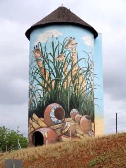
Kaapmuiden(Cape Mouth) is a small farming town situated at the confluence of the Kaap and Crocodile Rivers in Mpumalanga, South Africa. The town lies just off the N4 national highway and is marked by a large abandoned silo visible from the road. The silo has since been repainted to add to tourism appeal. The farms in the region produce sugarcane, subtropical fruit and vegetables. The town began as a junction on the Netherlands-South African Railway Company (NZASM)'s Pretoria - Delagoa Bay railway line.

Komatipoort is a town situated at the confluence of the Crocodile and Komati Rivers in Mpumalanga province, South Africa. The town is 8 km from the Crocodile Bridge Gate into the Kruger Park, and just 5 km from the Mozambique border and 65 km from the Eswatini border.

Skukuza, a town in Mpumalanga located 57 km east of Hazyview at the confluence of the N'waswitshaka and Sabie Rivers, is the administrative headquarters of the Kruger National Park.
Malamulele can refer to the town of Malamulele or the area of Malamulele. Both the town and area are in the Limpopo province of South Africa and predominantly occupied by Tsonga people. Malamulele town has one provincial road and one regional road; the R81 to Giyani and the R524 to Thohoyandou respectively. Malamulele is flanked by two rivers, Levubu River (Rivhubye) to the west and Letaba River to the east, meanwhile the Shingwedzi River runs from Malamulele West to Malamulele East, joining the Olifants in Mozambique on its way to the Indian Ocean. Malamulele is the seat of the Collins Chabane Local Municipality.
The Kruger National Park is a South African National Park and one of the largest game reserves in Africa. Originally known as The Sabi Game Reserve, it became a game reserve in 1898. The park became known as Kruger National Park in 1926, when it was named after Paul Kruger.

Marloth Park is a holiday town situated in northeastern South Africa in the Mpumalanga province.

Shingwedzi is a rest camp and ranger's post situated in the northern section of the Kruger National Park. The camp is located on the southern bank of the Shingwedzi River, for which it is named, in Limpopo province, South Africa. The surrounding country formerly constituted the Singwitsi Reserve, proclaimed in 1903, which encompassed over 5,000 square kilometers. The region was over-hunted by the end of the 19th century, its big game depleted and its elephant population completely decimated. The name "Shingwedzi" is of Tsonga origin, and was perhaps derived from "Shing-xa-goli", perhaps a local chieftain, and "njwetse", the sound of iron rubbing against iron.

Lower Sabie is one of Kruger National Park's Main rest camps and is situated on the southern bank of the Sabie River, in the southeastern section of the park. It is connected to the main Skukuza camp by the H4-1 tarred road, which is often considered to be the busiest road in the park.

Skukuza Airport is the only commercial airport in Kruger National Park, located near Skukuza, in the Mpumalanga province in South Africa. The airport was established in 1958 and was named in honour of James Stevenson-Hamilton, the first warden of the Kruger national park. In 2018, the airport was dubbed "the prettiest airport in the world" by Forbes.
Sabi Sand Game Reserve is located adjacent to the Kruger National Park in the Lowveld of Mpumalanga, South Africa. Officially named Sabi Sand Wildtuin, the Sabi Sand Game Reserve consists of a group of private game reserves. The Newington Gate is at 24°52′9″S31°24′16″E and west of the Kruger Gate and Skukuza camp of Kruger Park. Other entrances are Gowrie Gate in the far north and Shaws Gate in the south.
The N'waswitshaka River and its tributaries are completely contained in the southern Kruger Park, Mpumalanga, South Africa. It has its origin near Pretoriuskop and joins the Sabie River at Skukuza. The name means "the happy one" in Xitsonga, and is said to relate to an individual who always smiled.
The Magnificent Seven Elephants were seven bull elephants who lived in Kruger National Park in South Africa through the 1980s. They were so-named for the impressive 50 kg of ivory in their tusks.

Letaba is a main rest camp along the Letaba River in the north-central region of Kruger National Park in South Africa. It is situated at the junction of the H1-5 and the H9 road westward to Phalaborwa gate. The name comes from the Sesotho word for "river of sand", because of the wide, generally shallow river.

Mopani is a rest camp in Kruger National Park, South Africa. It lies along the northern shore of the Pioneer Dam on the Tsendze River.
