Related Research Articles

A moraine is any accumulation of unconsolidated debris, sometimes referred to as glacial till, that occurs in both currently and formerly glaciated regions, and that has been previously carried along by a glacier or ice sheet. It may consist of partly rounded particles ranging in size from boulders down to gravel and sand, in a groundmass of finely-divided clayey material sometimes called glacial flour. Lateral moraines are those formed at the side of the ice flow, and terminal moraines were formed at the foot, marking the maximum advance of the glacier. Other types of moraine include ground moraines and medial moraines.
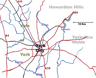
The Vale of York is an area of flat land in the northeast of England. The vale is a major agricultural area and serves as the main north–south transport corridor for Northern England.

Glaciology is the scientific study of glaciers, or more generally ice and natural phenomena that involve ice.

The Wisconsin Glacial Episode, also called the Wisconsin glaciation, was the most recent glacial period of the North American ice sheet complex. This advance included the Cordilleran Ice Sheet, which nucleated in the northern North American Cordillera; the Innuitian ice sheet, which extended across the Canadian Arctic Archipelago; the Greenland ice sheet; and the massive Laurentide Ice Sheet, which covered the high latitudes of central and eastern North America. This advance was synchronous with global glaciation during the last glacial period, including the North American alpine glacier advance, known as the Pinedale glaciation. The Wisconsin glaciation extended from approximately 75,000 to 11,000 years ago, between the Sangamonian Stage and the current interglacial, the Holocene. The maximum ice extent occurred approximately 25,000–21,000 years ago during the last glacial maximum, also known as the Late Wisconsin in North America.

The Oak Ridges Moraine is an ecologically important geological landform in the Mixedwood Plains of south-central Ontario, Canada. The moraine covers a geographic area of 1,900 square kilometres (730 sq mi) between Caledon and Rice Lake, near Peterborough. One of the most significant landforms in southern Ontario, the moraine gets its name from the rolling hills and river valleys extending 160 km (99 mi) from the Niagara Escarpment east to Rice Lake. It was formed 12,000 years ago by advancing and retreating glaciers. The moraine is a contested site in Ontario, since it stands in the path of major urban development.

The Last Glacial Period (LGP) occurred from the end of the Eemian to the end of the Younger Dryas, encompassing the period c. 115,000 – c. 11,700 years ago. The LGP is part of a larger sequence of glacial and interglacial periods known as the Quaternary glaciation which started around 2,588,000 years ago and is ongoing. The definition of the Quaternary as beginning 2.58 million years ago (Mya) is based on the formation of the Arctic ice cap. The Antarctic ice sheet began to form earlier, at about 34 Mya, in the mid-Cenozoic. The term Late Cenozoic Ice Age is used to include this early phase.
Till plains are an extensive flat plain of glacial till that forms when a sheet of ice becomes detached from the main body of a glacier and melts in place, depositing the sediments it carried. Ground moraines are formed with melts out of the glacier in irregular heaps, forming rolling hills. Till plains are common in areas such as the Midwestern United States, due to multiple glaciation events that occurred in the Holocene epoch. During this period, the Laurentide Ice Sheet advanced and retreated during the Pleistocene epoch. Till plains created by the Wisconsin glaciation cover much of the Midwest, including North Dakota, South Dakota, Indiana, Minnesota, Wisconsin, Iowa, Illinois, and northern Ohio.

Glacial landforms are landforms created by the action of glaciers. Most of today's glacial landforms were created by the movement of large ice sheets during the Quaternary glaciations. Some areas, like Fennoscandia and the southern Andes, have extensive occurrences of glacial landforms; other areas, such as the Sahara, display rare and very old fossil glacial landforms.
The Oak Ridges Moraine is a geological landform that runs east-west across south central Ontario, Canada. It developed about 12,000 years ago, during the Wisconsin glaciation in North America. A complex ridge of sedimentary material, the moraine is known to have partially developed under water. The Niagara Escarpment played a key role in forming the moraine in that it acted as a dam for glacial meltwater trapped between it and two ice lobes.

The Riss glaciation, Riss Glaciation, Riss ice age, Riss Ice Age, Riss glacial or Riss Glacial is the second youngest glaciation of the Pleistocene epoch in the traditional, quadripartite glacial classification of the Alps. The literature variously dates it to between about 300,000 to 130,000 years ago and 347,000 to 128,000 years ago. It coincides with the Saale glaciation of North Germany. The name goes back to Albrecht Penck and Eduard Brückner who named this cold period after the river Riss in Upper Swabia in their three-volume work Die Alpen im Eiszeitalter published between 1901 and 1909.

Ringland is a rural village in Norfolk, England, situated in the valley of the River Wensum, approximately 7 miles (11 km) north-west of Norwich. Parts of the Wensum valley within Ringland parish constitute a Site of Special Scientific Interest. The village has a population of 260, and it has an area of 1.95 square miles (5.1 km2).

Salthouse is a village and a civil parish in the English county of Norfolk. It is situated on the salt marshes of North Norfolk. It is 3.8 miles (6.1 km) north of Holt, 5.4 miles (8.7 km) west of Sheringham and 26.3 miles (42.3 km) north of Norwich. The village is on the A149 coast road between King's Lynn and Great Yarmouth. The nearest railway station is at Sheringham for the Bittern Line which runs between Sheringham, Cromer and Norwich. The nearest airport is Norwich International Airport. The landscape around Salthouse lies within the Norfolk Coast AONB and the North Norfolk Heritage Coast. The civil parish has an area of 6.22 km2 (2.40 sq mi) and in 2001 had a population of 196 in 88 households, the population increasing to 201 at the 2011 Census. For the purposes of local government, the parish falls within the district of North Norfolk.
Beacon Hill is the highest point in the English county of Norfolk as well as East Anglia. The hill is located 0.75 miles (1.2 km) south of the village of West Runton on the North Norfolk coast. At its summit the hill is 105 metres (344 ft) above sea level. The hill is also known as Roman Camp. The summit and surrounding woodlands are now in the care of the National Trust. A track, named Calves Well Lane, running west from Sandy Lane leads to a car park which is maintained by donations made to the National Trust collection box provide on the edge of the car park. Litter bins and benches make Beacon Hill an ideal location for picnics. There are several footpaths to follow across the area.

Kelling Heath is a 89.4-hectare (221-acre) biological Site of Special Scientific Interest between Holt and Weybourne in Norfolk. It is in the Norfolk Coast Area of Outstanding Natural Beauty.
The Norfolk Coast Area of Outstanding Natural Beauty is a protected landscape in Norfolk, England. It covers over 450 km2 of coastal and agricultural land from The Wash in the west through coastal marshes and cliffs to the sand dunes at Winterton in the east. It was designated AONB in 1968, under the National Parks and Access to the Countryside Act 1949.

The Geology of Yorkshire in northern England shows a very close relationship between the major topographical areas and the geological period in which their rocks were formed. The rocks of the Pennine chain of hills in the west are of Carboniferous origin whilst those of the central vale are Permo-Triassic. The North York Moors in the north-east of the county are Jurassic in age while the Yorkshire Wolds to the south east are Cretaceous chalk uplands. The plain of Holderness and the Humberhead levels both owe their present form to the Quaternary ice ages. The strata become gradually younger from west to east.

Boulder Park National Natural Landmark, of Douglas County, Washington, along with the nearby McNeil Canyon Haystack Rocks and Sims Corner Eskers and Kames natural landmarks, illustrate well-preserved examples of classic Pleistocene ice stagnation landforms that are found in Washington. These landforms include numerous glacial erratics and haystack rocks that occur near and on the Withrow Moraine, which is the terminal moraine of the Okanogan ice lobe.

The North Shore Highlands are a physiographic and ecological region of the U.S. state of Minnesota in central North America. They were formed by a variety of geologic processes, but are principally composed of rock created by magma and lava from a rift about 1.1 billion years ago, which rock formations are interspersed with and overlain by glacial deposits. Their ecology derives from these origins, with thin, rocky soils supporting flora and fauna typical of their northern, inland location.
The glacial series refers to a particular sequence of landforms in Central Europe that were formed during the Pleistocene glaciation beneath the ice sheets, along their margins and on their forelands during each glacial advance.
References
- ↑ "Field Guide to the Geology of North Norfolk: Briton's Lane". The Northfolk Project. Retrieved 20 November 2018.