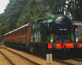
The North Norfolk Railway (NNR) – also known as the "Poppy Line" – is a 5+1⁄4-mile (8.4 km) heritage steam railway in Norfolk, England, running between the towns of Sheringham and Holt. The North Norfolk Railway is owned and operated as a public limited company, originally called Central Norfolk Enterprises Limited. The railway is listed as exempt from the UK Railways (Interoperability) Regulations 2000.

Wroxham is a village and civil parish in the English county of Norfolk. The civil parish of Wroxham has an area of 6.21 square kilometres, and in 2001, had a population of 1,532 in 666 households. A reduced population of 1,502 in 653 households was noted in the 2011 Census. The village is situated within the Norfolk Broads on the south side of a loop in the middle reaches of the River Bure. It lies in an elevated position above the Bure, between Belaugh Broad to the west, and Wroxham Broad to the east and south east. Wroxham is some eight miles north-east of Norwich, to which it is linked by the A1151 road. The village and broad lie in an area of fairly intensive agriculture, with areas of wet woodland adjoining the broad and river. For the purposes of local government, the parish falls within the district of Broadland although the river, broad and their immediate environs fall within the executive area of the Broads Authority. On the northern side of the Bure is the village of Hoveton, often confused with Wroxham.
Hoveton is a village and civil parish in the English county of Norfolk. It is located within the Norfolk Broads, and immediately across the River Bure from the village of Wroxham. Whilst Hoveton is north of the river, Wroxham is south; but many people refer to the whole settlement as "Wroxham".

The Bure Valley Railway is a 15 in minimum gauge visitors' attraction in Norfolk, England. It was created on the original disused full-gauge bed of a defunct passenger service to incorporate a new, adjacent pedestrian footpath.

The River Bure is a river in the county of Norfolk, England, most of it in the Broads. The Bure rises near Melton Constable, 11 miles (18 km) upstream of Aylsham, which was the original head of navigation. Nowadays, the head of navigation is 10 miles (16 km) downstream at Coltishall Bridge. After Aylsham Lock and Burgh Bridge, the Bure passes through Buxton Lammas, Coltishall, Belaugh, Wroxham, Horning, past St. Benet's Abbey, through Oby, Acle, Stokesby, along the northern border of the Halvergate Marshes, through Runham and Great Yarmouth where it meets Breydon Water and flows into the sea at Gorleston.
The Bure Valley Path is a 9-mile (14 km) long walking trail and cycling trail in Norfolk, England. It runs alongside the Bure Valley Railway, a heritage railway from Wroxham to Aylsham.

Aylsham is a historic market town and civil parish on the River Bure in north Norfolk, England, nearly 9 mi (14 km) north of Norwich. The river rises near Melton Constable, 11 miles (18 km) upstream from Aylsham and continues to Great Yarmouth and the North Sea, although it was only made navigable after 1779, allowing grain, coal and timber to be brought up river.

The Aylsham Bypass Tunnel is the only railway tunnel in Norfolk, England currently open to trains. It carries the narrow gauge Bure Valley Railway under the Aylsham Bypass. The former Norfolk & Suffolk Joint Railway's Cromer Tunnel at Cromer is disused.

Buxton is a village in the parish of Buxton with Lamas, in the Broadland district of the county of Norfolk, England. It is located between Norwich and Aylsham, and is separated from Lamas by the River Bure. In 2021, it had a population of 1,295.

Ingworth is a village and a civil parish in the English county of Norfolk. It is 1.7 miles (2.7 km) north of Aylsham, 14.3 miles (23.0 km) north of Norwich, 7.3 miles (11.7 km) east of North Walsham and 9 miles (14 km) south-southwest of Cromer. The nearest railway station is at North Walsham, which is located on the Bittern Line between Sheringham and Norwich. The nearest airport is Norwich International Airport. The village is bypassed by the A140 road, 0.9 miles (1.4 km) to the west. The village and parish of Ingworth had, in the 2001 census, a population of 94. For the purposes of local government, the village falls within the district of North Norfolk. The population taken at the 2011 census remained less than 100 and was included in the civil parish of Erpingham.

Hoveton & Wroxham railway station is on the Bittern Line in Norfolk, England, serving the village of Hoveton and the adjacent village of Wroxham. It is 8 miles 61 chains (14.1 km) down the line from Norwich and is situated between Salhouse and Worstead.

Coltishall railway station serves the village of Coltishall in Norfolk, and is currently operated by the Bure Valley Railway.
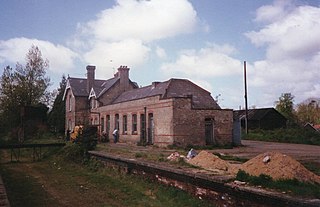
Aylsham South railway station served the town of Aylsham in Norfolk from 1880 to 1981. The period station buildings were subsequently demolished in 1989 to allow for the construction of Aylsham railway station, the northern terminus of the Bure Valley Railway, a narrow gauge operation which reuses some of the trackbed of the old railway line.
The following are lists of recreational walks in Norfolk, England.

Cromer High railway station was the first station opened in Cromer, Norfolk, in England. It is situated to the south on the outskirts of the town on a steep escarpment. Built initially by the short-lived East Norfolk Railway, the station was incorporated into the Great Eastern Railway, who had operated the services from the beginning. It served as the terminus of Great Eastern Railway services from London and Norwich. Initially named Cromer on opening, it was renamed Cromer High on 27 September 1948.
Cromer Links Halt was a railway station on the outskirts of Cromer. It was on the now disused Norfolk and Suffolk Joint Railway line between Roughton Road Junction and Overstrand station. It opened on 9 July 1923, only to close thirty years later on 7 April 1953.
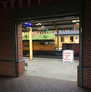
Aylsham railway station is located in the town of Aylsham in Norfolk and is the northern terminus of the Bure Valley Railway, a narrow gauge operation which reuses some of the trackbed of a former standard gauge branch line that closed in 1977. The station occupies the same site as the former Aylsham South railway station, which served the town between 1880 and 1952.

Railways have played an important part in the history and development of the English county of Norfolk. It currently has thirty open National Rail stations, though there were once well over a hundred.

The East Norfolk Railway was a pre-grouping railway company operating a standard gauge 25 mile, mostly single track, railway running between Norwich Thorpe railway station and Cromer in the English county of Norfolk. It opened in 1874, reaching Cromer three years later, and remains mostly operational. The company also operated a branch between Wroxham and County School, which closed to passengers in 1952, and had proposed a branch to Blakeney in 1878, which was never constructed.

The Mermaid (river) is a minor tributary of the River Bure in Norfolk, England, and is approximately 6 kilometres (3.7 mi) in length.
