
The River Thames, known alternatively in parts as the River Isis, is a river that flows through southern England including London. At 215 miles (346 km), it is the longest river entirely in England and the second-longest in the United Kingdom, after the River Severn.

The River Waveney is a river which forms the boundary between Suffolk and Norfolk, England, for much of its length within The Broads. The earliest attestation of the name is from 1275, Wahenhe, from *wagen + ea, meaning the river by a quagmire.
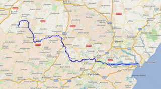
The River Stour is a major river in East Anglia, England. It is 47 miles (76 km) long and forms most of the county boundary between Suffolk to the north, and Essex to the south. It rises in eastern Cambridgeshire, passes to the east of Haverhill, through Cavendish, Sudbury, Bures, Nayland, Stratford St Mary and Dedham. It becomes tidal just before Manningtree in Essex and joins the North Sea at Harwich.

The River Avon is a river in the southwest of England. To distinguish it from a number of other rivers of the same name, it is often called the Bristol Avon. The name 'Avon' is loaned from an ancestor of the Welsh word afon, meaning 'river'.

The Aire and Calder Navigation is the canalised section of the Rivers Aire and Calder in West Yorkshire, England. The first improvements to the rivers above Knottingley were completed in 1704 when the Aire was made navigable to Leeds and the Calder to Wakefield, by the construction of 16 locks. Lock sizes were increased several times, as was the depth of water, to enable larger boats to use the system. The Aire below Haddlesey was bypassed by the opening of the Selby Canal in 1778. A canal from Knottingley to the new docks and new town at Goole provided a much shorter route to the River Ouse from 1826. The New Junction Canal was constructed in 1905, to link the system to the River Don Navigation, by then part of the Sheffield and South Yorkshire Navigation.

The Trent is the third longest river in the United Kingdom. Its source is in Staffordshire, on the southern edge of Biddulph Moor. It flows through and drains the North Midlands into the Humber Estuary. The river is known for dramatic flooding after storms and spring snowmelt, which in the past often caused the river to change course.

The Tamar is a river in south west England that forms most of the border between Devon and Cornwall. A large part of the valley of the Tamar is protected as the Tamar Valley National Landscape, and some is included in the Cornwall and West Devon Mining Landscape due to its historic mining activities.
The River Tone is a river in the English county of Somerset. The river is about 33 kilometres (21 mi) long. Its source is at Beverton Pond near Huish Champflower in the Brendon Hills, and is dammed at Clatworthy Reservoir. The reservoir outfall continues through Taunton and Curry and Hay Moors, which are designated as a Site of Special Scientific Interest. Finally, it flows into the River Parrett at Burrowbridge.

The River Weaver is a river, navigable in its lower reaches, running in a curving route anti-clockwise across west Cheshire, northern England. Improvements to the river to make it navigable were authorised in 1720 and the work, which included eleven locks, was completed in 1732. An unusual clause in the enabling Act of Parliament stipulated that profits should be given to the County of Cheshire for the improvement of roads and bridges, but the navigation was not initially profitable, and it was 1775 before the first payments were made. Trade continued to rise, and by 1845, over £500,000 had been given to the county.

The English River Thames is navigable from Cricklade or Lechlade to the sea, and this part of the river falls 71 meters (234 feet). There are 45 locks on the river, each with one or more adjacent weirs. These lock and weir combinations are used for controlling the flow of water down the river, most notably when there is a risk of flooding, and provide for navigation above the tideway.

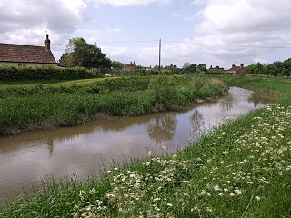
The River Blackwater is a river in Essex, England. It rises as the River Pant in the northwest of the county, just east of Saffron Walden, and flows in a generally southeast direction to Bocking, near Braintree, via Great Sampford and Great Bardfield. At Bocking, it becomes the River Blackwater, and veers east to flow past Bradwell Juxta Coggeshall and Coggeshall. It then veers south, flowing past Kelvedon and Witham, before reaching Maldon. There, it veers east again and empties into the Blackwater Estuary, which in turn meets the North Sea at Mersea Island.

Teddington Lock is a complex of three locks and a weir on the River Thames between Ham and Teddington in the London Borough of Richmond upon Thames, England. Historically in Middlesex, it was first built in 1810.
The Nottingham Canal is a canal in the English counties of Nottinghamshire and Derbyshire. As built, it comprised a 14.7-mile (23.7 km) long main line between the River Trent just downstream of Trent Bridge in Nottingham and Langley Mill in Derbyshire. At the same time as the main line of the canal was built by its proprietors, the separate Trent Navigation Company built the Beeston Cut, from the main line at Lenton in Nottingham to rejoin the River Trent upstream of Nottingham, thus bypassing the difficult section of navigation through Trent Bridge. The section of the main line between Trent Bridge and Lenton, together with the Beeston Cut, is still in use, forming part of the navigation of the River Trent and sometimes referred to as the Nottingham & Beeston Canal. The remainder of the main line of the canal beyond Lenton has been abandoned and partially filled.

The Millennium Ribble Link is a linear water park and new navigation which links the once-isolated Lancaster Canal in Lancashire, England to the River Ribble. The Lancaster Canal was never connected to the rest of the English waterways network, because the planned aqueduct over the River Ribble was never built. Instead, a tramway connected the southern and northern parts of the canal. An idea for a connecting link following the course of the Savick Brook was proposed in 1979, and the Ribble Link Trust campaigned for twenty years to see it built. The turn of the Millennium, and the funds available from the Millennium Commission for projects to mark the event was the catalyst for the project to be implemented, and although completion was delayed, the navigation opened in July 2002.

The Thames Path is a National Trail following the River Thames from one of its sources near Kemble in Gloucestershire to the Woolwich foot tunnel, south east London. It is about 185 miles (298 km) long. A path was first proposed in 1948 but it only opened in 1996.

The River Wey Navigation and Godalming Navigation together provide a 20-mile (32 km) continuous navigable route from the River Thames near Weybridge via Guildford to Godalming. Both waterways are in Surrey and are owned by the National Trust. The River Wey Navigation connects to the Basingstoke Canal at West Byfleet, and the Godalming Navigation to the Wey and Arun Canal near Shalford. The navigations consist of both man-made canal cuts and adapted parts of the River Wey.

The Selby Canal is a 6-mile (9.7 km) canal with two locks, which bypasses the lower reaches of the River Aire in Yorkshire, England, from the village of West Haddlesey to the town of Selby where it joins the River Ouse. It opened in 1778, and provided the main outlet for the Aire and Calder Navigation until 1826, when it was bypassed by a new cut from Ferrybridge to Goole. Selby steadily declined after that, although traffic to York still used the canal.

The Hackney Cut is an artificial channel of the Lee Navigation built in England in 1769 by the River Lea Trustees to straighten and improve the Navigation. It begins at the Middlesex Filter Beds Weir, below Lea Bridge, and is situated in the (modern) London Borough of Hackney. When built it contained two pound locks and a half-lock, but was rebuilt to handle larger barges in the 1850s, and now only Old Ford Lock, which is actually a duplicated pair, remains.
131 Commando Squadron Royal Engineers is an Army Reserve unit and part of 24 Commando Regiment Royal Engineers. It provides engineering support to UK Commando Force. and is the largest Army Reserve Commando unit. The squadron has deployed worldwide to provide combat engineer support to the UKCF, often deploying in small sub-units. 131 was first raised in 1947 as an airborne engineer regiment, and reached a strength of over 1,000 trained parachute engineers by the early 1960s. Between 1 April 1978 and 1 October 2015, the unit was an independent Commando squadron under operational command of HQ 3 Cdo Bde RM. On 2 October 2015, it formally became the third squadron of 24 Commando Engineer Regiment.

The Trent Navigation Company existed from 1783 to 1940. It was responsible for control of navigation on the River Trent in England.


